

A massive wildfire erupted in New Jersey’s Pine Barrens in April 2025, highlighting the delicate line between nature’s cycles and modern-day risk.
Fueled by a severe drought, the fire rapidly spread across more than 15,000 acres, forcing evacuations and road closures. NASA satellites provided critical data and imagery that helped track the fire’s behavior and spread. While fires are a natural part of this ecosystem, the increasing presence of humans and climate shifts make such events increasingly perilous.
Fire in the Pines: A Natural Yet Dangerous Force
Wildfires have long played a natural role in shaping New Jersey’s Pinelands, also known as the Pine Barrens. This fire-prone coastal forest is home to pitch pines and other species that actually benefit from occasional burns, which help regenerate the ecosystem.
But today, with hundreds of thousands of people living within or near these forests, fires can quickly shift from being ecologically beneficial to dangerously destructive, especially during periods of drought. One such example unfolded on April 22, 2025, when a fire broke out in a wildlife management area near Waretown. In just two days, it had grown into one of the largest wildfires New Jersey has experienced in decades.
NASA Satellites Capture the Blaze
On April 23, NASA’s Landsat 9 satellite captured imagery of the blaze using the OLI-2 (Operational Land Imager-2). In the natural-color image (above, upper), thick smoke blankets the landscape, partially hiding the fire’s path. In a companion false-color image (above, lower) that uses shortwave infrared, near-infrared, and visible light bands (OLI bands 6-5-3), the contrast is clearer: healthy vegetation appears green, while recently burned areas show up as brown. A sand mine is also visible in the upper left corner. A wider natural-color view provides further context below.

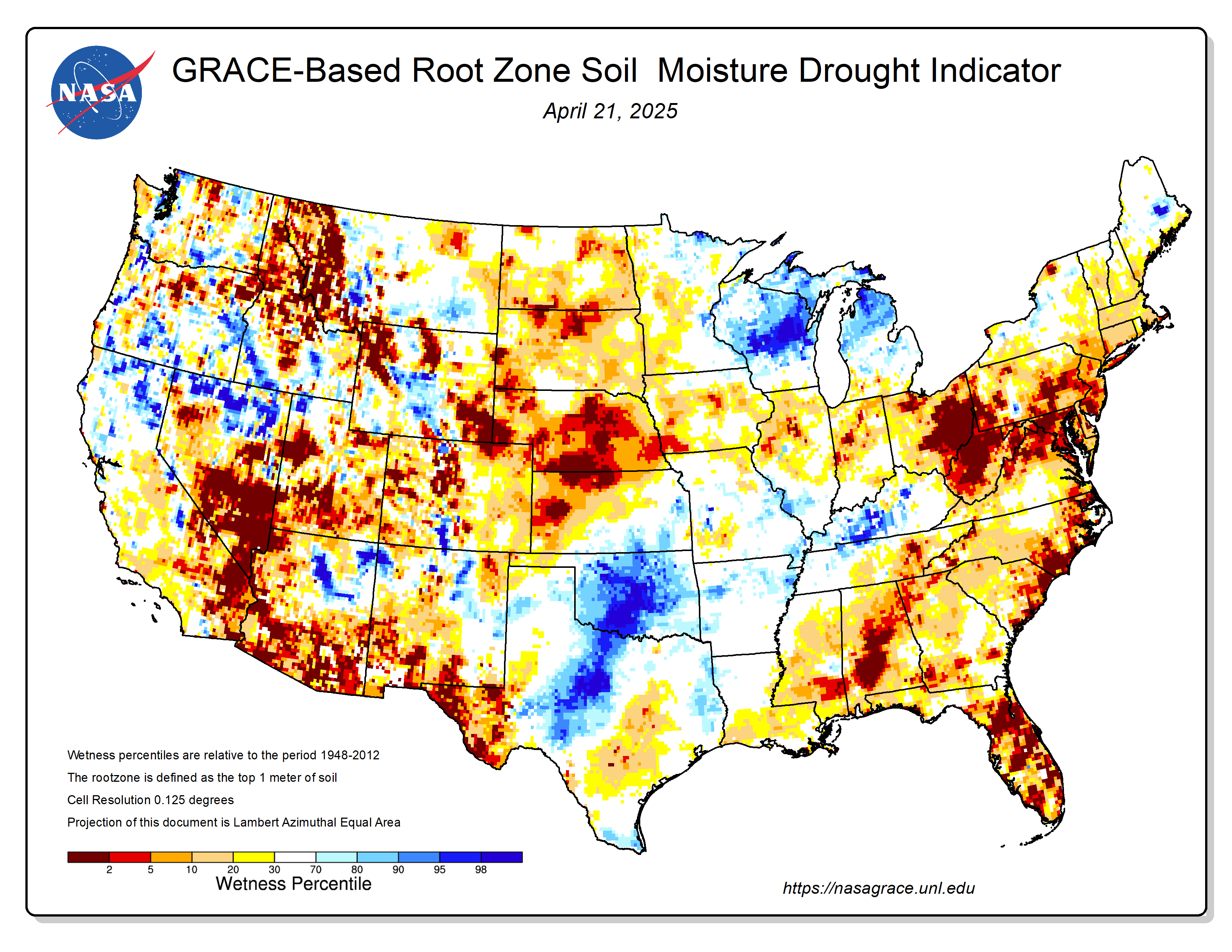
Drought Sets the Stage for Disaster
An ongoing drought made the Pine Barrens particularly susceptible to fire in spring 2025. An April analysis of shallow groundwater and soil moisture using NASA observations from the GRACE (Gravity Recovery and Climate Experiment) and GRACE-FO (GRACE Follow On) satellites showed anomalously dry conditions, according to data posted by the National Drought Mitigation Center. At the time of the fire, the U.S. Drought Monitor had classified drought in the region as “severe.”
Evacuations and Smoke Spread Across the Region
According to news reports, the fast-moving fire led to evacuations of large numbers of people from Lacey and Ocean townships, threatened many homes, and sent smoke wafting toward New York City. At times, officials closed both the Garden State Parkway and Route 532. As of April 24, more than 15,000 acres had burned, and the fire was 50 percent contained, according to the New Jersey Forest Fire Service. As of that date, all evacuation orders had been lifted and the Garden State Parkway had been reopened, the fire service noted.
NASA’s Role in Tracking Wildfires
NASA’s satellite data is part of a global system of observations that are used to track fire behavior and analyze emerging trends. Among the real-time wildfire monitoring tools that NASA makes available are FIRMS (Fire Information for Resource Management System) and the Worldview browser.
NASA Earth Observatory images by Wanmei Liang, using Landsat data from the U.S. Geological Survey.
Never miss a breakthrough: Join the SciTechDaily newsletter.
Follow us on Google and Google News.