
ROVs offer fresh perspectives on the ancient history of the ocean.
Marine and coastal geoscience are essential for understanding both ancient and modern geological processes, assessing offshore and coastal hazards, and studying the impacts of climate change. Because deep-sea environments are largely inaccessible, researchers must rely on specialized methods to investigate the ocean floor.
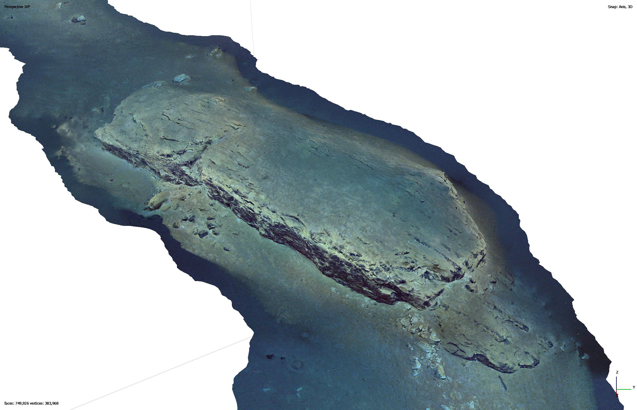
One widely used technique is offshore drilling, which recovers core samples for laboratory analysis. While valuable, this approach is costly and comes with practical limitations. A recent study published in Geosphere presents a more affordable alternative: using a remotely operated vehicle (ROV) to capture high-resolution images of exposed rock formations on the seafloor. These images are then used to create detailed virtual outcrops for geological analysis.
Constructing a virtual outcrop is essential for reconstructing a region’s ancient history and understanding the geological processes and hazards that have shaped it. ROVs can also collect rock samples from various locations on the ocean floor, which allows scientists to deepen their analysis through visual rock identification and laboratory examination. While ROVs cannot retrieve samples from the subsurface like ocean drilling can, this more cost-effective method can retrieve samples from the ocean floor and video record seafloor morphology which cannot be done with ocean drilling.
The data collected via ROV exploration is both highly valuable and more accessible to a wider range of scientists.
The Mona Rift’s Seismic Hazards
The Mona Rift, located northwest of Puerto Rico, is a seismically active area that presents real hazards to Puerto Rico’s coastal communities. One of the most devastating seismic events in the region was the 1918 tsunami. Triggered by a magnitude 7.2 earthquake, this event caused an underwater landslide, leading to widespread flooding in Puerto Rican coastal towns (ten Brink et al., 2023).
Despite the risks, data on the Mona Rift remains limited due to a lack of previous drilling expeditions, making it an ideal location for ROV-based research. Investigating this region’s geology can help scientists better understand local geologic hazards and prepare for future natural disasters. For example, analyzing the geologic history can uncover a more detailed record of past earthquakes preserved in the rocks. This knowledge allows scientists to make more informed assessments about current earthquake-related hazards, including the magnitude and frequency of potential future events.
Such valuable insights are crucial for protecting communities at risk of earthquake-related hazards.
Virtual Outcrop Methodology
A team led by Dr. Uri S. ten Brink, a geoscientist with the U.S. Geological Survey, deployed an ROV at water depths ranging from approximately 5,000 to 13,000 feet to study the region.
Using a combination of video frames and seven ROV-collected rock samples, the team determined the age and geologic history of the Mona Rift. Dr. ten Brink compared the video data collected by the ROV to footage “from a passing car along an outcrop on land.” He emphasized that this method allows scientists to “extract so much more from existing data than was previously assumed.”
New Insights
Although there are correlations between offshore and onshore rock formations, ten Brink’s research revealed discrepancies between the two environments. The team identified a 330-foot gap in the geologic record between the onshore and offshore formations, along with variations in rock thicknesses that suggest distinct geological evolutions.
Their stratigraphic analysis indicates that the Mona Rift is approximately 3.3 million years old, making it roughly 30 million years younger than some of the surrounding rock formations. According to Dr. ten Brink, this suggests that the Mona Rift “is young” and that tectonic rifting is “occurring at a higher rate than previously assumed.”
Seismic Risk and Coastal Communities
By combining offshore data collected by the ROV with existing onshore data, ten Brink and his team developed a more comprehensive geological history of the region. The ROV’s ability to gather both visual and physical data provided unique insights into the geologic record, demonstrating its potential for cost-effective research in remote, deep-water environments. This approach not only advances our understanding of ancient geological events but also has practical applications for evaluating and mitigating future risks to coastal communities.
The findings of this research are particularly valuable for understanding the geological processes that have contributed to destructive hazards in Puerto Rico’s past—and for identifying risks that could emerge in the future. Employing ROVs for offshore stratigraphic and geological analysis has provided a fresh perspective on the geology and geologic hazards of offshore Puerto Rico.
References: “Field geology under the sea with a remotely operated vehicle: Mona Rift, Puerto Rico” by Uri S. ten Brink, Or M. Bialik, Jason D. Chaytor, Claudia H. Flores and Marcie Purkey Phillips, 30 October 2024, Geosphere.
DOI: 10.1130/GES02762.1
“Seafloor Observations Eliminate a Landslide as the Source of the 1918 Puerto Rico Tsunami” by Uri ten Brink, Jason Chaytor, Claudia Flores, Yong Wei, Simon Detmer, Lilian Lucas, Brian Andrews and Aggeliki Georgiopoulou, 3 January 2023, Bulletin of the Seismological Society of America.
DOI: 10.1785/0120220146
Never miss a breakthrough: Join the SciTechDaily newsletter.
Follow us on Google and Google News.