Lidar mapping study reveals vast landscape modifications that still influence construction and farming.
A lidar mapping study using a cutting-edge aerial mapping technology shows ancient residents of Teotihuacan moved astonishing quantities of soil and bedrock for construction and reshaped the landscape in a way that continues to influence the contours of modern activities in this part of Mexico. The work is published in the open-access journal, PLOS One.
The paper also shows how Teotihuacan’s engineers re-routed two rivers to align with points of astronomical significance, identified hundreds of previously unknown architectural features, and documented over 200 archaeological features that have been destroyed by mining and urbanization since the 1960s.
“We don’t live in the past, but we live with the legacies of past actions. In a monumental city like Teotihuacan, the consequences of those actions are still fresh on the landscape,” said first author Nawa Sugiyama, a professor of anthropology at UC Riverside.
Teotihuacan, about 25 miles (40 kilometers) northeast of modern Mexico City, was the largest city in the Americas and one of the largest anywhere in the ancient world. It existed from about 100 BCE-550 CE— about 1,000-2,000 years ago— and covered 8 square miles (21 square kilometers). At its height, it consisted of numerous pyramids, plazas, and well-designed residential and commercial neighborhoods housing a population of around 100,000. Some of the pyramids and other structures are visible above ground today, but most of the city’s remains lie buried beneath modern fields, buildings, and other activity areas.
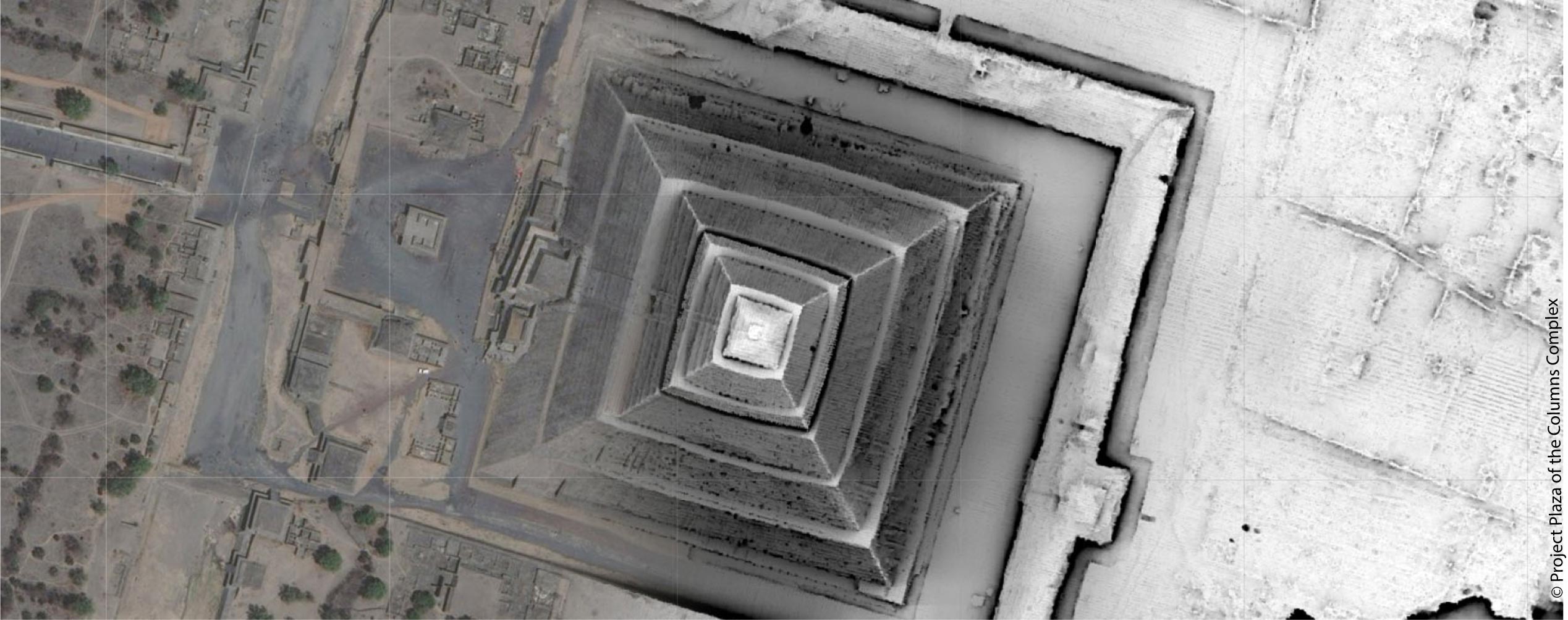
To map the below-ground parts of Teotihuacan, Nawa Sugiyama and co-authors Saburo Sugiyama at Arizona State University; Tanya Catignani at George Mason University; Adrian S. Z. Chase at Claremont University; and Juan C. Fernandez-Diaz at Houston University used lidar, a mapping technology that measures the amount of time it takes light from a laser to bounce back from an object. Archaeologists often use lidar to discover buried features covered by dense forests or open fields but rarely deploy the technology where archaeological remains lie beneath urban areas.
“Lidar is often perceived as a revolutionary tool to find ancient features hidden in plain sight, but we found the lidar map to be extremely messy and hard to interpret. Many of the features we identified were modern with ancient roots. But then we realized there is a far more interesting story behind this trend,” said Nawa Sugiyama.
Because the sheer scale of construction at Teotihuacan suggested massive modification of the ancient landscape, Sugiyama’s group thought that lidar could help elucidate the relationship between the layout of Teotihuacan and modern activities that overlay it. The researchers confirmed the lidar findings with surveys by foot and comparisons to previous mapping efforts.
They found that the builders of Teotihuacan leveled the ground down to the bedrock and, in some cases, quarried the bedrock itself to use as construction and fill material. In just one portion of the city, called the Plaza of the Columns Complex, the authors calculated that roughly 372,056 square meters (92 acres) of artificial ground accumulated over the course of roughly 300 years of construction that had been quarried elsewhere in the Teotihuacan Valley. In three of the main pyramid complexes, the authors estimate that 2,423,411 square meters (599 acres) of rock, dirt, and adobe had been used.
This major reshaping of the landscape affects the arrangement of modern construction and activities. The authors found that 65% of urban areas contained property or modern features that aligned orthogonally within 3 degrees of 15 degrees east of astronomical north— the same alignment as Teotihuacan. Rock fences were built along areas that lidar and excavation revealed to have underground ancient walls that made modern-day plowing difficult.
Teotihuacan engineers also rerouted the Rio San Juan and the San Lorenzo River, which cross the city. Rio San Juan follows the Teotihuacan orientation for 3 km (1.9 mi) as it traverses the city center while the San Lorenzo River has a very distinct orientation, 8 degrees south of astronomical east for 4.9 km (3 mi). Previous research has interpreted them as major canals of symbolic and calendric significance.
The lidar map also showed that other sections of canals and rivers, many still actively used today, were altered at various points along its course, frequently coinciding with the Teotihuacan directionalities. A total of 16.9 km (10.5 mi) of the hydrological systems visible on the modern terrain had origins in the Early Classic Teotihuacan landscape.
On the lidar map, the group identified 298 features and 5,795 human-made terraces that had not been previously recorded. However, they also identified over 200 known features that have been destroyed by mining since 2015.
“We can’t fight modern urbanization. The lidar map provides a snapshot of these ancient features that are being abolished at an alarming rate that would otherwise go unnoticed. It’s one of many ways we can preserve our heritage landscape,” said Nawa Sugiyama.
The authors plan to use their lidar map to create a three-dimensional geospatial database that allows them to visualize stratigraphic and surface data, natural and artificial features, and to document the true extent of humans as geomorphic agents over long periods of time in the Teotihuacan Valley.
Reference: “Humans as geomorphic agents: Lidar detection of the past, present and future of the Teotihuacan Valley, Mexico” by Nawa Sugiyama, Saburo Sugiyama, Tanya Catignani, Adrian S. Z. Chase and Juan C. Fernandez-Diaz, 20 September 2021, PLOS One.
DOI: 10.1371/journal.pone.0257550
Never miss a breakthrough: Join the SciTechDaily newsletter.
Follow us on Google and Google News.
2 Comments
“In three of the main pyramid complexes, the authors estimate that 2,423,411 square meters of rock, dirt, and adobe had been used.”
Why are “square meters” used instead of cubic meters?
… when it comes to a Pyramid now I am kind of more interested into an Egyptian ones, and are some of them on the angle of 41-42 and 50-52, …