New research reveals a concerning pattern of rapid and extreme climate changes across the Arctic, particularly in Siberia, the Canadian Northwest Territories, and Alaska.
Utilizing over three decades of geospatial data, researchers pinpointed areas where permafrost, critical to the global climate, is in jeopardy due to increased warming and drying, highlighting the urgent need for focused climate adaptation strategies.
Ecological Changes in the Arctic
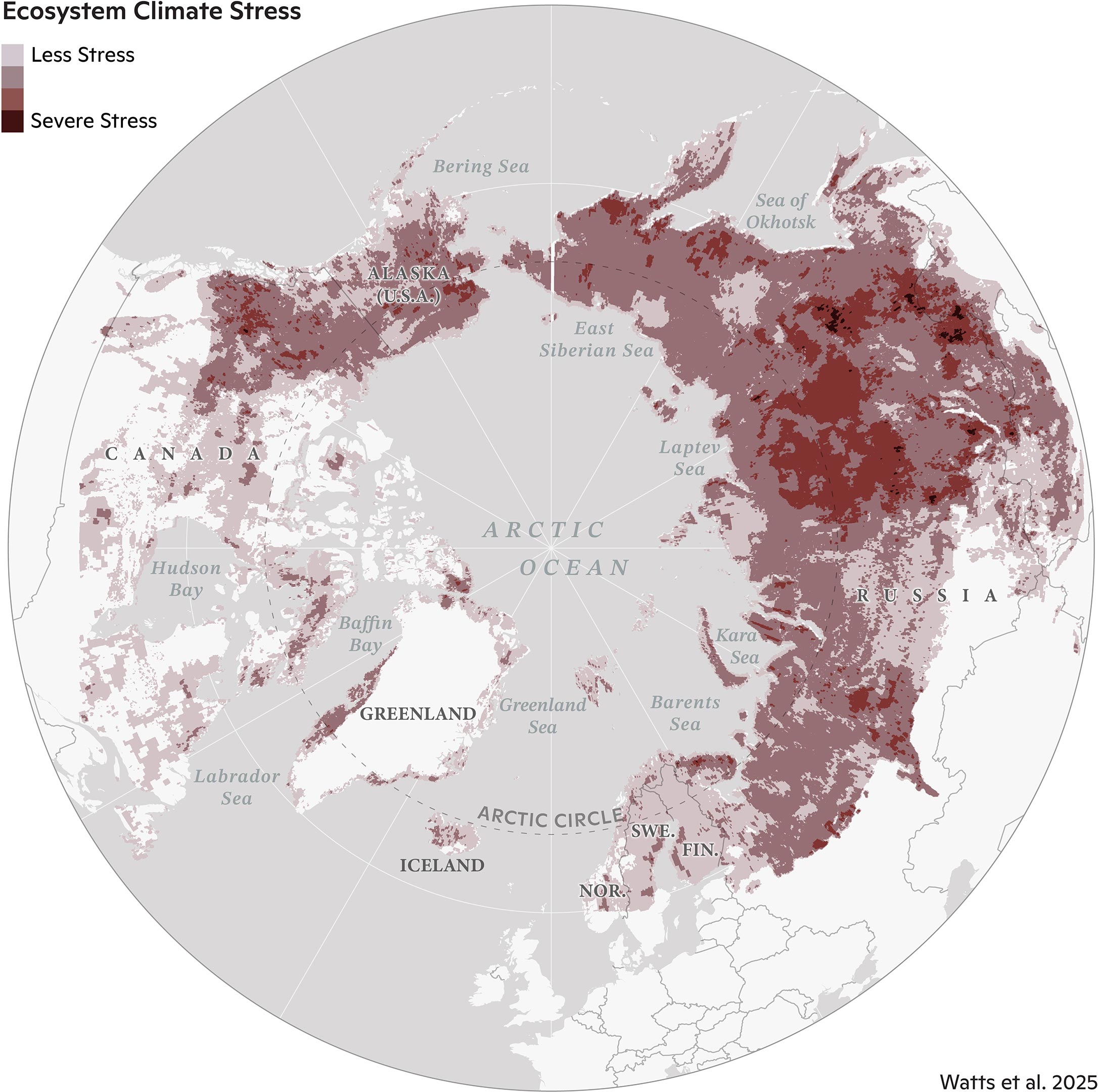
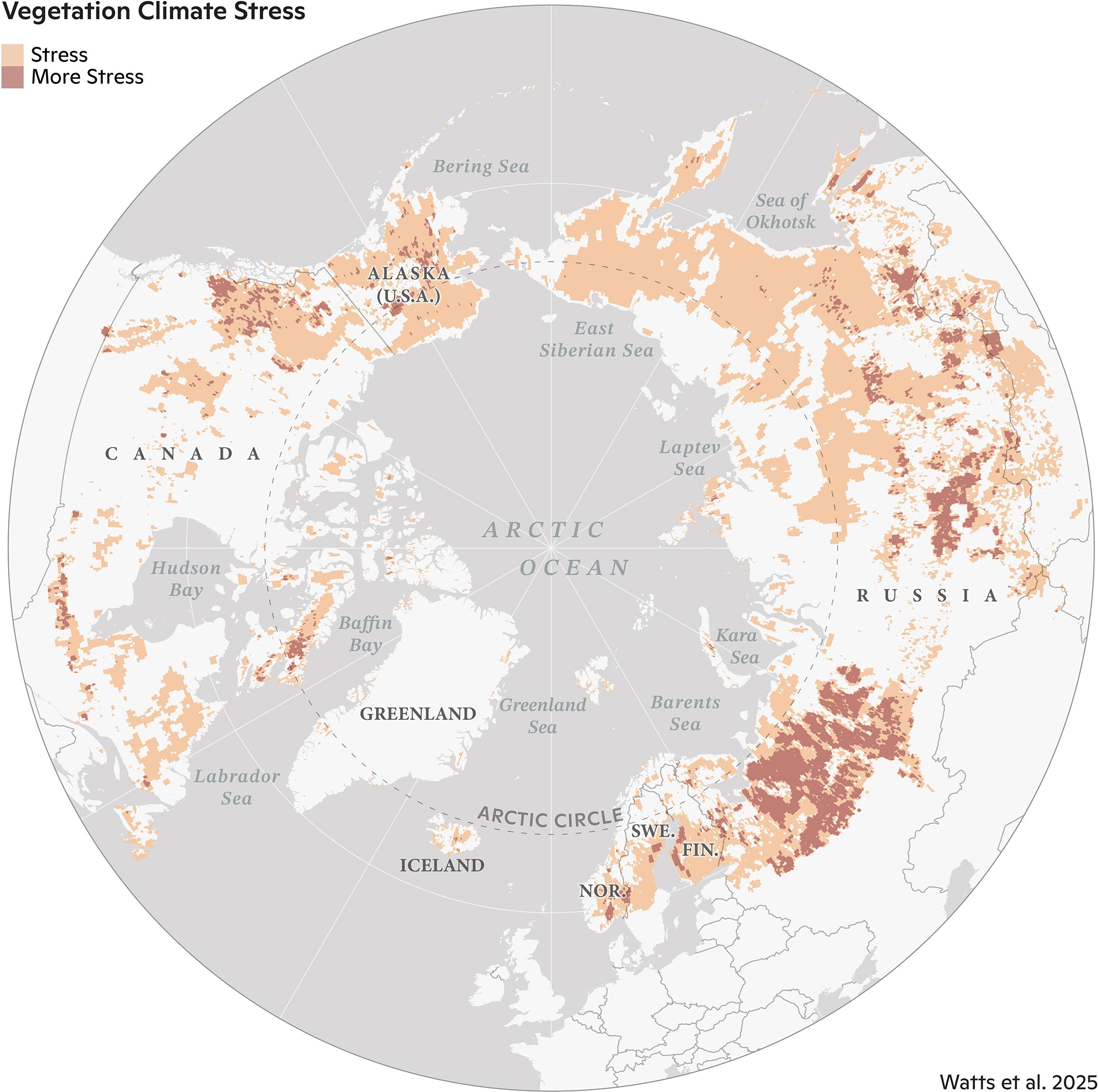
Ecological warning signals have intensified across the Arctic over the past 40 years, according to recent research. Many of the regions undergoing the most rapid changes are concentrated in Siberia, the Canadian Northwest Territories, and Alaska. This study, published today (January 16) in Geophysical Research Letters, offers a detailed view of ecosystems facing some of the most extreme and accelerated climate shifts on the planet.
A significant number of these climate-stressed areas are characterized by permafrost — soil that remains frozen throughout the year. These regions have experienced dramatic warming and drying trends in recent decades, further exacerbating their vulnerability.
Comprehensive Climate Assessment
To identify these “hotspots,” a team of researchers from Woodwell Climate Research Center, the University of Oslo, the University of Montana, the Environmental Systems Research Institute (Esri), and the University of Lleida used more than 30 years of geospatial data and long-term temperature records to assess indicators of ecosystem vulnerability in three categories: temperature, moisture, and vegetation.
Building on assessments like the NOAA Arctic Report Card, the research team went beyond evaluating isolated metrics of change and looked at multiple variables at once to create a more complete, integrated picture of climate and ecosystem changes in the region.
“Climate warming has put a great deal of stress on ecosystems in the high latitudes, but the stress looks very different from place to place and we wanted to quantify those differences,” said Dr. Jennifer Watts, Arctic program director at Woodwell Climate and lead author of the study. “Detecting hotspots at the local and regional level helps us not only to build a more precise picture of how Arctic warming is affecting ecosystems, but to identify places where we really need to focus future monitoring efforts and management resources.”
The team used spatial statistics to detect “neighborhoods,” or regions of particularly high levels of change during the past decade.
Tailored Climate Adaptation
“This study is exactly why we have developed these kinds of spatial statistic tools in our technology. We are so proud to be working closely with Woodwell Climate on identifying and publishing these kinds of vulnerability hotspots that require effective and immediate climate adaptation action and long-term policy,” said Dr. Dawn Wright, chief scientist at Esri. “This is essentially what we mean by the ‘Science of Where.’”
Varied Responses to Climate Change
The findings paint a complex and concerning picture.
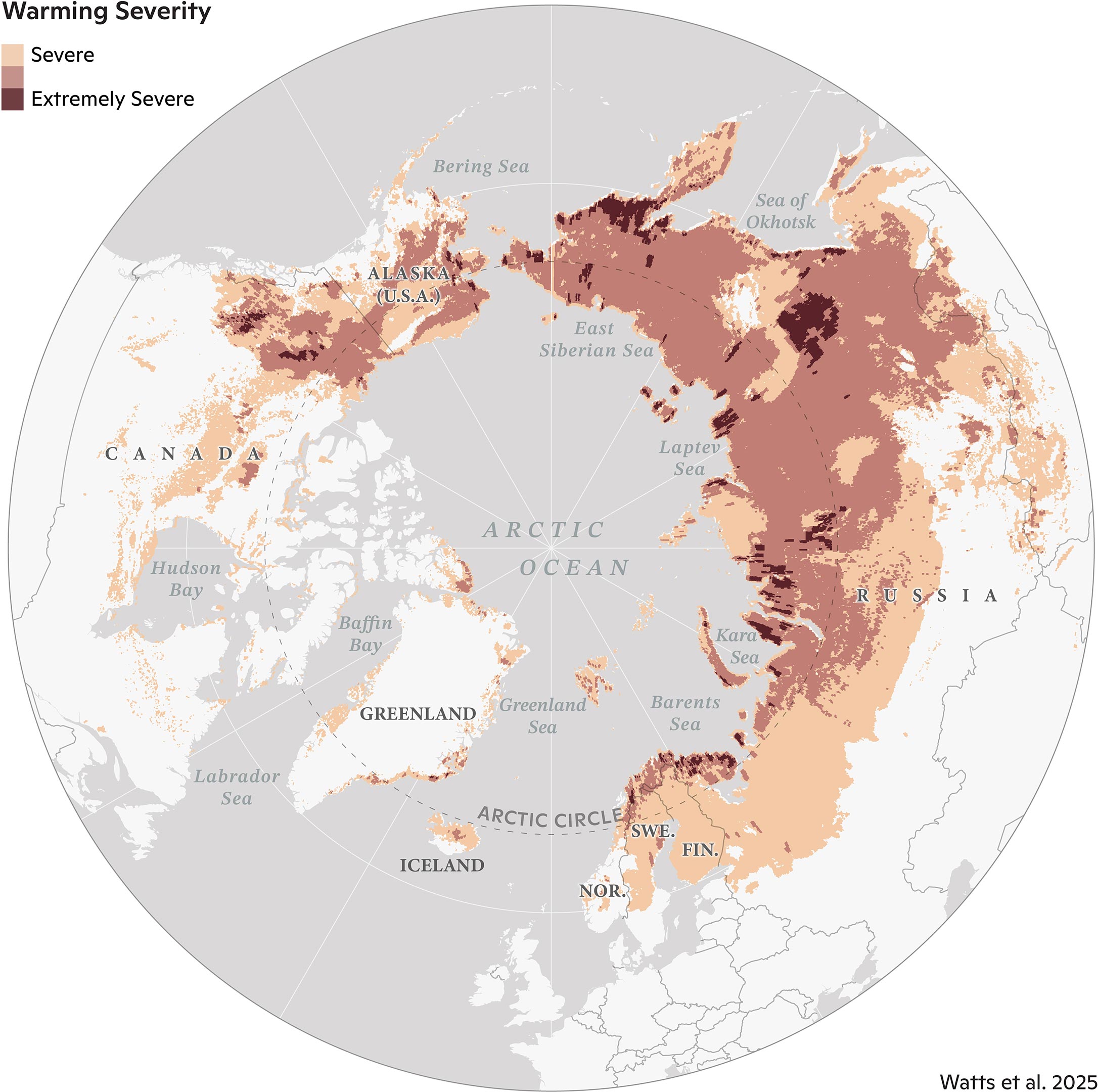
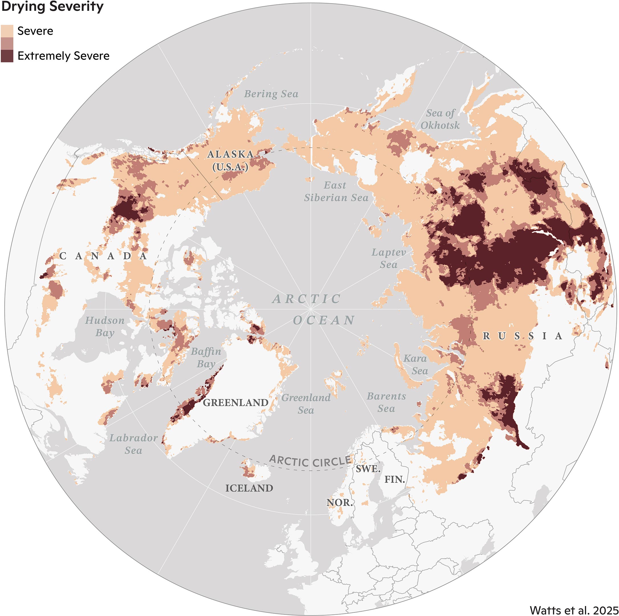
The most substantial land warming between 1997-2020 occurred in the far eastern Siberian tundra and throughout central Siberia. Approximately 99% of the Eurasian tundra region experienced significant warming, compared to 72% of Eurasian boreal forests. While some hotspots in Siberia and the Northwest Territories of Canada grew drier, the researchers detected increased surface water and flooding in parts of North America, including Alaska’s Yukon-Kuskokwim Delta and central Canada. These increases in water on the landscape over time are likely a sign of thawing permafrost.
Permafrost: The Common Threat
Among the 20 most vulnerable places the researchers identified, all contained permafrost.
“The Arctic and boreal regions are made up of diverse ecosystems, and this study reveals some of the complex ways they are responding to climate warming,” said Dr. Sue Natali, lead of the Permafrost Pathways project at Woodwell Climate and co-author of the study. “However, permafrost was a common denominator—the most climate-stressed regions all contained permafrost, which is vulnerable to thaw as temperatures rise. That’s a really concerning signal.”
Localized Monitoring for Effective Management
For land managers and other decision-makers, local and regional hotspot mapping like this can serve as a more useful monitoring tool than region-wide averages. Take, for instance, the example of COVID-19 tracking data: maps of county-by-county wastewater data tend to be more helpful tools to guide decision-making than national averages, since rates of disease prevalence and transmission can vary widely among communities at a given moment in time. So, too, with climate trends: local data and trend detection can support management and adaptation approaches that account for unique and shifting conditions on the ground.
The significant changes the team detected in the Siberian boreal forest region should serve as a wakeup call, said Watts. “These forested regions, which have been helping take up and store carbon dioxide, are now showing major climate stresses and increasing risk of fire. We need to work as a global community to protect these important and vulnerable boreal ecosystems, while also reining in fossil fuel emissions.”
Reference: “Regional Hotspots of Change in Northern High Latitudes Informed by Observations From Space” by Jennifer D. Watts, Stefano Potter, Brendan M. Rogers, Anna-Maria Virkkala, Greg Fiske, Kyle A. Arndt, Arden Burrell, Kevin Butler, Bob Gerlt, John Grayson, Tatiana A. Shestakova, Jinyang Du, Youngwook Kim, Frans-Jan W. Parmentier and Susan M. Natali, 16 January 2025, Geophysical Research Letters.
DOI: 10.1029/2023GL108081
This project was supported by the Gordon and Betty Moore Foundation and through the TED Audacious Project for Permafrost Pathways: Connecting Science, People, and Policy for Arctic Justice and Global Climate.
Never miss a breakthrough: Join the SciTechDaily newsletter.
Follow us on Google and Google News.
1 Comment
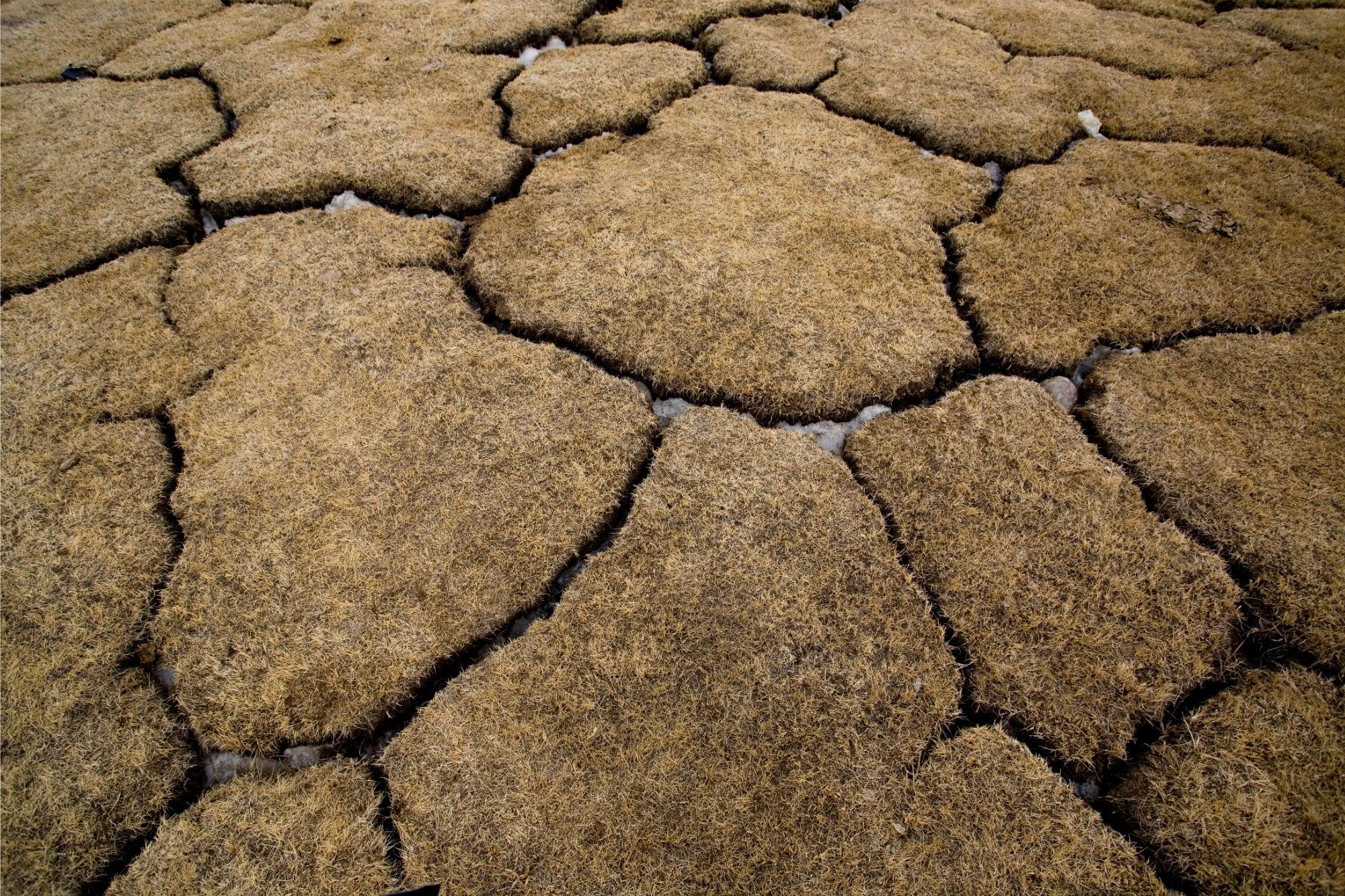
Why does ‘Patterned Ground’ (as shown in the lede picture) exist in the Arctic tundra when warming is supposedly recent but it takes thousands of years of freeze-thaw cycles to create the patterned ground?
Why is East Antarctica not experiencing warming like other places in the world, notably polar tundra?