
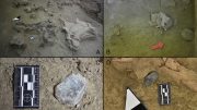
Recent MBARI research has discovered that the large seafloor depressions off Central California, known as the Sur Pockmark Field, are maintained by sediment gravity flows rather than methane gas eruptions. This insight is pivotal for guiding seafloor management and offshore wind farm site assessments. Credit: SciTechDaily.com
Data from MBARI’s advanced underwater robots point to erosion during intermittent sediment flows as the mechanism maintaining these circular depressions for hundreds of thousands of years.
Recent research conducted by the Monterey Bay Aquarium Research Institute (MBARI) has uncovered that sediment flows, rather than methane gas eruptions, are responsible for maintaining large, circular depressions known as pockmarks on the seafloor off Central California. This study, carried out in collaboration with the United States Geological Survey (USGS) and Stanford University, was published today (May 21) in the Journal of Geophysical Research: Earth Surface. The findings are crucial for guiding decisions about the responsible management and use of California’s seafloor, including evaluating sites for upcoming offshore wind farm projects.
Sur Pockmark Field Overview
The Sur Pockmark Field, located off the coast of Big Sur, California, spans an area comparable to the city of Los Angeles and features over 5,200 of these circular depressions. Each depression measures roughly 200 meters (656 feet) in diameter—about two football fields—and is five meters (16 feet) deep. Previously, studies in other parts of the world suggested that such seafloor depressions were formed and sustained by methane gas bubbling up through the sediments. However, with plans to construct wind farms in the waters off Central California, concerns had arisen about the potential impact of methane on the seafloor’s stability.

New research on a field of pockmarks—large, circular depressions on the seafloor—offshore of Central California has revealed that powerful sediment flows, not methane gas eruptions, maintain these prehistoric formations. This work by a team of researchers from MBARI, USGS, and Stanford University provides important information to guide decision-making about responsible use and management of the seafloor off California, including site assessments for the development of offshore wind farms. Credit: © 2019 MBARI
Research Methodology and Findings
The data collected by MBARI researchers and their collaborators found no evidence of methane at this site. Instead, the research team has proposed that sediment gravity flows—similar to an avalanche of mud, sand, and water moving along the seafloor—that have occurred in this region intermittently for hundreds of thousands of years maintain these seafloor formations.
“There are many unanswered questions about the seafloor and its processes,” said MBARI Senior Research Technician Eve Lundsten, who led this work. “This research provides important data about the seafloor for resource managers and others considering potential offshore sites for underwater infrastructure to guide their decision-making.”
The research team deployed MBARI’s advanced underwater robots to study the Sur Pockmark Field. First, autonomous underwater vehicles (AUVs)—torpedo-shaped, self-guided robots—mapped the region. Previous maps of the seafloor were collected by sonar mounted on ships, but the distance between the ocean surface and the seafloor resulted in low-resolution data. AUVs can travel closer to the seafloor to visualize the terrain below in much greater detail. MBARI’s seafloor mapping AUVs also carried technology to profile the sub-bottom layers of sediment below the seafloor.
Technological Advances in Seafloor Mapping
These maps then guided sampling with MBARI’s remotely operated vehicle (ROV) Doc Ricketts. Operated by the research team in the control room aboard an MBARI research vessel, the ROV Doc Ricketts collected sediment samples to reconstruct the history of individual pockmarks.
These pockmarks are located on the continental margin, a dynamic section of the seafloor that connects the relatively shallow continental shelf to the deep sea. Sediment gravity flows can move massive amounts of material through this region intermittently. The data and samples collected by MBARI technology helped the research team piece together the history of sediment movements over this part of the seafloor.
The team found multiple layers of sandy deposits, called turbidites, in the sediment samples taken from the pockmarks and the sub-bottom images of the pockmark field. These deposits indicated that large sediment gravity flows in the region have occurred intermittently for at least the last 280,000 years. These sediment gravity flows appear to cause erosion in the center of each pockmark, maintaining these unique underwater morphologic features over time.
“We collected a massive amount of data, allowing us to make a surprising link between pockmarks and sediment gravity flows. We were unable to determine exactly how these pockmarks were initially formed, but with MBARI’s advanced underwater technology, we’ve gained new insight into how and why these features have persisted on the seafloor for hundreds of thousands of years,” said Lundsten.
Global Context and Future Research
Seafloor pockmarks have been found elsewhere around the world. In those locations, pockmarks have been associated with the release of methane gas or other fluids from the seafloor. Bubbling methane could potentially cause the seafloor to be unstable, which could pose risks for structures on the seafloor, like the anchors for offshore wind turbines. In October 2018, the U.S. Bureau of Ocean Energy Management (BOEM) announced areas offshore of Central California for potential wind energy leasing. MBARI quickly moved to conduct this research to answer critical questions about the stability of the seafloor to guide development of offshore wind energy in California.
“Expanding renewable energy is critical to achieving the dramatic cuts in carbon dioxide emissions needed to prevent further irreversible climate change. However, there are still many unanswered questions about the possible environmental impacts of offshore wind energy development,” said MBARI President and CEO Chris Scholin. “This research is one of many ways that MBARI researchers are answering fundamental questions about our ocean to help inform decisions about how we use marine resources.”
Concluding Insights
Because of the extensive efforts of MBARI, USGS, BOEM, and NOAA as part of the interagency Expanding Pacific Research and Exploration of Submerged Systems (EXPRESS) cooperative research campaign, the Sur Pockmark Field is now one of the best-studied areas of seafloor on the west coast of North America. However, there are still many questions to answer about these pockmarks, including how these features were initially formed hundreds of thousands of years ago.
Background
The seafloor plays an important ecological and societal role. It provides vital habitat for marine life and supports our modern infrastructure. However, we still have a lot to learn about seafloor processes. MBARI has an active research program that uses advanced robots to study and map the seafloor offshore of Central California. MBARI’s Continental Margin Processes Team, led by Senior Scientist Charlie Paull, investigates how the morphology of the continental margin—where the continental shelf transitions to the abyssal plain—is sculpted and changed over time.
The Sur Pockmark Field is located offshore of Big Sur, California, along the continental margin at a depth of 500 to 1,500 meters (approximately 1,600 to 5,200 feet). Some of these pockmarks were initially discovered by MBARI scientists in 1998 during a seafloor survey using ship-mounted multibeam sonar. Additional ship surveys conducted by MBARI collaborators at the USGS and NOAA in 2018 showed that the pockmarks extend southward into the region off Morro Bay. These surveys have revealed more than 5,200 pockmarks spread out over 1,300 square kilometers (500 square miles), making this area the largest known pockmark field in North America.
The seafloor offshore of this remote stretch of the Central California coastline has historically been one of the least-studied regions of the continental margin off the west coast of North America. For the past six years, MBARI’s Continental Margin Processes Team has been working to understand the origins of the pockmark formations, establish whether they are geologically active, and determine if they are areas of special biological significance.
Past research by MBARI, BOEM, and USGS examined the biological communities within the Sur Pockmark Field. This new research aimed to understand the geological processes that form and maintain pockmarks within the field.
The research team used mapping AUVs developed by engineers in MBARI’s Seafloor Mapping Lab to visualize a portion of the Sur Pockmark Field in greater detail.
Bathymetric surveys by these underwater robots mapped 317 of the 5,251 pockmarks at one-meter resolution. At this fine resolution, it became apparent the pockmarks have very smooth, gradually-sloped sides. The pockmarks are on average 156 meters (512 feet) across, nearly circular in shape, and fairly evenly spaced apart. Additionally, the AUVs were outfitted with a chirp sub-bottom profiler that uses sound to reveal layers of sediment below the seafloor surface. Chirp profiles captured portions of the subsurface below approximately 200 pockmarks at the site.
These surveys captured an assortment of detailed seafloor data that would not be visible from ship-based mapping with multibeam sonar. That data allowed targeted sampling of pockmarks within the field.
The Continental Margin Processes Team conducted 30 dives with two of MBARI’s ROVs to get a closer look at 21 pockmarks within the field. The team recorded 185 hours of seafloor video footage inside and adjacent to pockmarks. MBARI’s ROV Doc Ricketts also collected 107 vibracores—a 1.5-meter (five-foot) core of sediment dislodged into a metal tube by high-frequency vibrations—and 433 pushcores—a shallower 24-centimeter (9.4-inch) sample of sediment—within and around five pockmarks.
A USGS cruise on the research vessel M/V Bold Horizon in 2019 collected deeper piston and gravity cores up to 7.5 meters (25 feet) in length. The piston cores were taken inside pockmarks and at background sites adjacent to but outside of the pockmarks for comparison.
Importantly, the research team found no evidence of methane gas in any of the samples or data that they collected. Instead, the subsurface profiles and sediment samples indicated that the pockmarks contain alternating layers of fine and coarse sediment.
The sandy deposits, or turbidites, were the key to unlocking the surprising story of massive sediment gravity flows passing over the whole area. Fine sediment on the seafloor was deposited slowly over time, then intermittent large sediment gravity flows left a characteristic layer of coarse sand. It appears these flows erode the pockmark centers, leaving behind sandy deposits across multiple pockmarks in the region at the same time.
Scientists have only recently begun to understand the patterns of erosion and deposition by sediment gravity flows in underwater canyons and channels. The Sur Pockmark Field is bordered by two channels—the Lucia Chica Channel to the north and the San Simeon Channel to the south—but is otherwise broad and open terrain.
Exactly how currents and sediments move over the dimpled surface of the Sur Pockmark Field is still unknown. However, the research team has proposed the unique seafloor morphology in this area may create flow patterns that erode the pockmark centers. In this region, sediment gravity flows are episodic, occurring tens of thousands of years apart. The last one was approximately 14,000 years ago. Computer modeling will be required to confirm if an unconfined flow passing over the pockmark field carries sufficient energy to erode and maintain the pockmarks.
Reference: “Pockmarks Offshore Big Sur, California Provide Evidence for Recurrent, Regional, and Unconfined Sediment Gravity Flows” by E. Lundsten, C. K. Paull, R. Gwiazda, S. Dobbs, D. W. Caress, L. A. Kuhnz, M. Walton, N. Nieminski, M. McGann, T. Lorenson, G. Cochrane and J. Addison, 21 May 2024, Journal of Geophysical Research: Earth Surface.
DOI: 10.1029/2023JF007374
Funding for this work was provided by the David and Lucile Packard Foundation, BOEM, and USGS.


“Instead, the research team has proposed that sediment gravity flows—similar to an avalanche of mud, sand, and water moving along the seafloor—that have occurred in this region intermittently for hundreds of thousands of years maintain these seafloor formations.”
It doesn’t make sense that down-slope turbidite flows would create circularly symmetric depressions and that there are no linear flow marks. I think that it is time to go back to the ‘drawing board.’
https://en.wikipedia.org/wiki/Turbidite