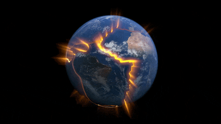
Computer simulations confirm that the African Superplume causes the unusual deformations and rift-parallel seismic anisotropy detected below the East African Rift System.
Continental rifting involves a combination of stretching and fracturing that penetrates deep within the Earth, explains geophysicist D. Sarah Stamps. This process pertains to the elongation of the lithosphere, Earth’s rigid outer layer. As it becomes more taut, the lithosphere’s upper sections undergo brittle changes, leading to rock fractures and earthquakes.
Stamps, who studies these processes by using computer modeling and GPS to map surface motions with millimeter precision, compares a rifting continent’s different deformation styles with playing with Silly Putty.
“If you hit Silly Putty with a hammer, it can actually crack and break,” said Stamps, associate professor in the Department of Geosciences, part of the Virginia Tech College of Science. “But if you slowly pull it apart, the Silly Putty stretches. So on different time scales, Earth’s lithosphere behaves in different ways.”
Whether in stretching or breaking, the deformation that comes with continental rifting usually follows predictable directional patterns in relation to the rift: The deformation tends to be perpendicular to the rift. The East African Rift System, the Earth’s largest continental rift system, has those rift-perpendicular deformations. But after measuring the rift system with GPS instruments for more than 12 years, Stamps also observed deformation that went in the opposite direction, parallel to the system’s rifts. Her team at the Geodesy and Tectonophysics Lab has worked to find out why.

Investigating the Forces Behind Rift-Parallel Deformations
In a recent study published in the Journal of Geophysical Research, the team explored the processes behind the East African Rift System using 3D thermomechanical modeling developed by the study’s first author, Tahiry Rajaonarison, a postdoctoral researcher at New Mexico Tech who earned his Ph.D. at Virginia Tech as a member of Stamps’s lab. His models showed that the rift system’s unusual, rift-parallel deformation is driven by northward mantle flow associated with the African Superplume, a massive upwelling of mantle that rises from deep within the Earth beneath southwest Africa and goes northeast across the continent, becoming more shallow as it extends northward.
Their findings, combined with insights from a study the researchers published in 2021 using Rajaonarison’s modeling techniques, could help clear up scientific debate on which plate-driving forces dominate the East African Rift System, accounting for both its rift-perpendicular and rift-parallel deformation: lithospheric buoyancy forces, mantle traction forces, or both.
As a postdoctoral researcher, Stamps began observing the East African Rift System’s unusual, rift-parallel deformation using data from GPS stations that measured signals from more than 30 satellites orbiting Earth, from about 25,000 kilometers away. Her observations have added a layer of complexity to the debate around what drives the rift system.
Lithospheric Buoyancy vs. Mantle Traction Forces
Some scientists see the rifting in East Africa as driven primarily by lithospheric buoyancy forces, which are relatively shallow forces attributed mainly to the rift system’s high topography, known as the African Superswell, and to density variations in the lithosphere. Others point to horizontal mantle traction forces, the deeper forces arising from interactions with the mantle flowing horizontally beneath East Africa, as the primary driver.
The team’s 2021 study found through 3D computational simulations that the rift and its deformation could be driven by a combination of the two forces. Their models showed that lithospheric buoyancy forces were responsible for the more predictable, rift-perpendicular deformation, but those forces couldn’t account for the anomalous, rift-parallel deformation picked up by Stamps’s GPS measurements.
In their newly published study, Rajaonarison again used 3D thermomechanical modeling, this time to focus on the source of the rift-parallel deformations. His models confirm that the African Superplume is responsible for the unusual deformations as well as rift-parallel seismic anisotropy observed beneath the East African Rift System.
Seismic Anisotropy and Its Link to Mantle Flow
Seismic anisotropy is the orientation or alignment of rocks in a particular direction in response to mantle flow, melt pockets, or pre-existing structural fabrics in the lithosphere, Stamps said. In this case, the rocks’ alignment followed the direction of the African Superplume’s northward mantle flow, which suggests mantle flow as their source.
“We are saying that the mantle flow is not driving the east-west, rift-perpendicular direction of some of the deformations, but that it may be causing the anomalous northward deformation parallel to the rift,” Rajaonarison said. “We confirmed previous ideas that lithospheric buoyancy forces are driving the rift, but we’re bringing new insight that anomalous deformation can happen in East Africa.”
Learning more about the processes involved in continental rifting, including these anomalous ones, will help scientists chip away at the complexity behind the breaking of a continent, which they’ve been attempting for decades. “We’re excited about this result from Dr. Rajaonarison’s numerical modeling because it provides new information about the complex processes that shape the Earth’s surface through continental rifting,” Stamps said.
Reference: “A Geodynamic Investigation of Plume-Lithosphere Interactions Beneath the East African Rift” by Tahiry A. Rajaonarison, D. Sarah Stamps, John Naliboff, Andrew Nyblade and Emmanuel A. Njinju, 27 March 2023, Journal of Geophysical Research Solid Earth.
DOI: 10.1029/2022JB025800
Never miss a breakthrough: Join the SciTechDaily newsletter.
Follow us on Google and Google News.
6 Comments
Good analytical resolve information on and about “Largest Continental Rift’ observation on the African geological splitting update.
“Computer simulations confirm …”
Computer simulations are only an approximation of reality and vary widely in their accuracy depending on assumptions and parameterizations. They can provide support for hypotheses, but are themselves only complex hypotheses subject to limitations on the range of applicability and are, as with climate models, often difficult to validate. Models are best used to provide insight on how several variables of interest interact.
Even though computational fluid dynamics models may suggest an aircraft design will work as intended, a prudent designer will build a scale model and test it in a wind tunnel before scaling it up to something a test pilot can fly. Models may provide supporting evidence for a hypothesis, but a claim of confirming the real world is one differential equation too far.
The African rift valley is running through Zambia. I can provide the exact location. In the past two weeks the tectonic plates have widened from,5m to 150m. Appropriate depth 1,000m
The fracturing and multi-direction of continents as well as the Northward Movement of continents is predicted by the Growth and Expansion of Planets that are in the slow transition phase from terrestrial planets to Gas Enveloped Planets. The continents move up, up, down, while the Ocean floors move up, up, up, and because growth can not be equal in all locations, Continents flee the locus of excess growth and expansion. On Earth that is in the Southern Hemisphere, On Mars it is in the Northern Hemisphere. The Up, up, down versus up,up, up means that Ocean floors rise slightly higher and faster than the continents because the source of materials to growth the Earth come out from under continents. The result is the bending down of the Ocean floors at the margins that creates the necessary gravitational differential that allows the initiation of the process of subduction. Without this process, and the Moon’s pumping action that moves the surface of the Earth up and down by around 2 feet, subduction would not have initiated, nor would it continue to slowly move cooling and densifying materials down under continents. Mars does not have this as it does not have a big enough Moon to add the energy required to pump the surface up and down, and it does not have a big enough magnetic field to torque the planet so it’s core spins faster inside, like Earth’s core does. One added extra rotation every 400 years. Our Moon is very useful to the Earth for lots of reasons, especially the ones that lead to all sorts of life forms on Earth.
Need examples for backup
Thank you for your knowledge. Now I have better understanding.