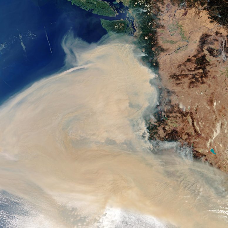
In this image, multiple fires can be seen in the states of California, Washington and Oregon – the areas hit hardest by the blazes – producing the thick plume of smoke which can be seen traveling westwards. Based on additional data from the Copernicus Sentinel-3 mission, as of Tuesday, the smoke was visible traveling 2000 km west of the active fires. Credit: Contains modified Copernicus Sentinel data (2020), processed by ESA, CC BY-SA 3.0 IGO
Western US states have been battling close to 100 wildfires, blanketing the majority of the west coast in smoke. Captured on 10 September, this Copernicus Sentinel-3 image shows the extent of the smoke plume which, in some areas, has caused the sky to turn orange.
In this image, multiple fires can be seen in the states of California, Washington and Oregon – the areas hit hardest by the blazes – producing the thick plume of smoke which can be seen traveling westwards. Based on additional data from the Copernicus Sentinel-3 mission, as of Tuesday, the smoke was visible traveling 2000 km west of the active fires.
The cities of Portland, Eureka, Eugene, San Francisco, and Sacramento are all blanked in smoke. In the top of the image, the cities of Vancouver and Seattle are visible.
Sentinel-3 is a two-satellite mission to supply the coverage and data delivery needed for Europe’s Copernicus environmental monitoring program. Each satellite’s instrument package includes an optical sensor to monitor changes in the color of Earth’s surfaces. It can be used, for example, to monitor ocean biology and water quality.

Be the first to comment on "Stunning Satellite Imagery of West Coast Wildfires Shows Portland, Eureka, Eugene, San Francisco, and Sacramento Blanked by Smoke"