
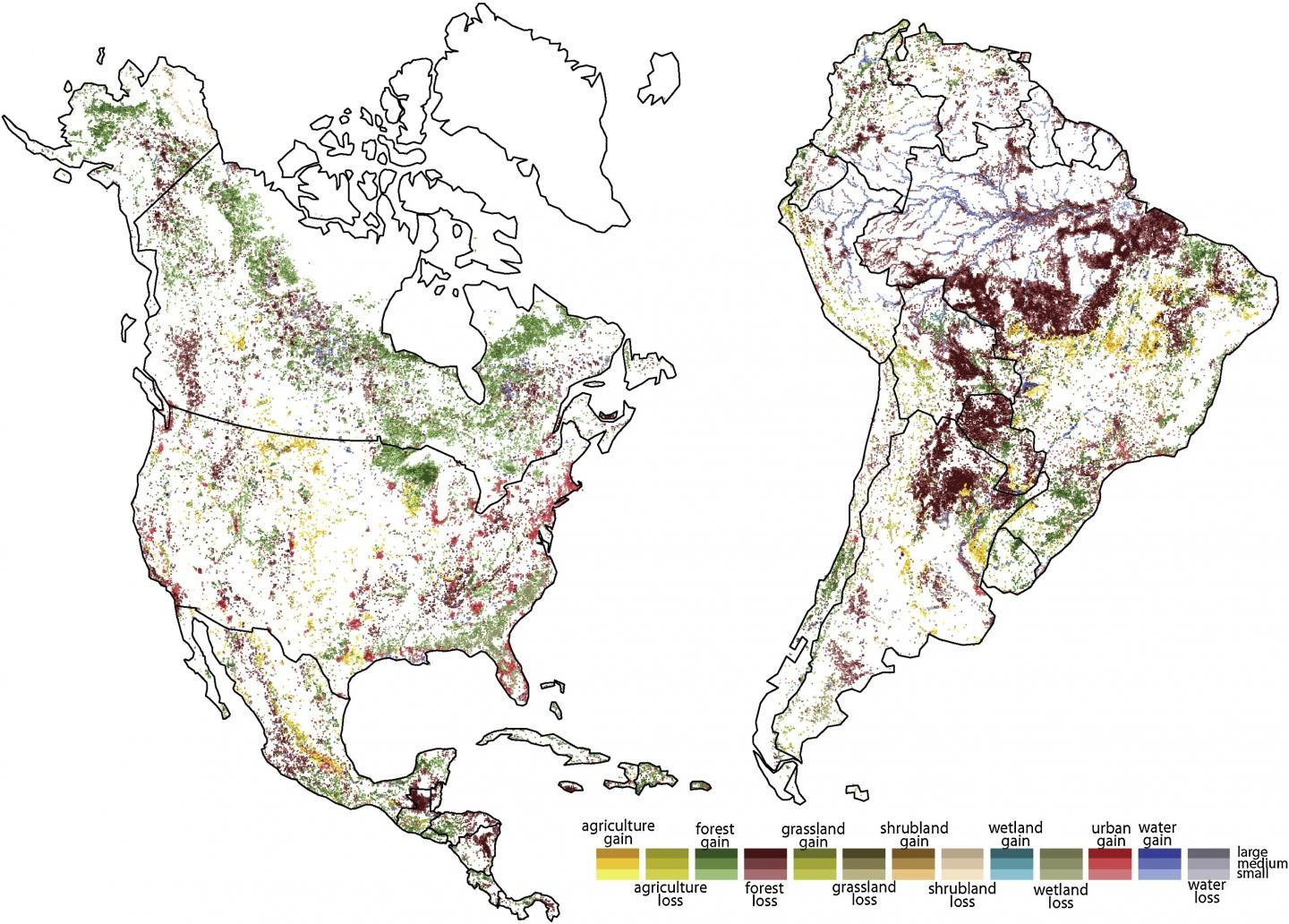
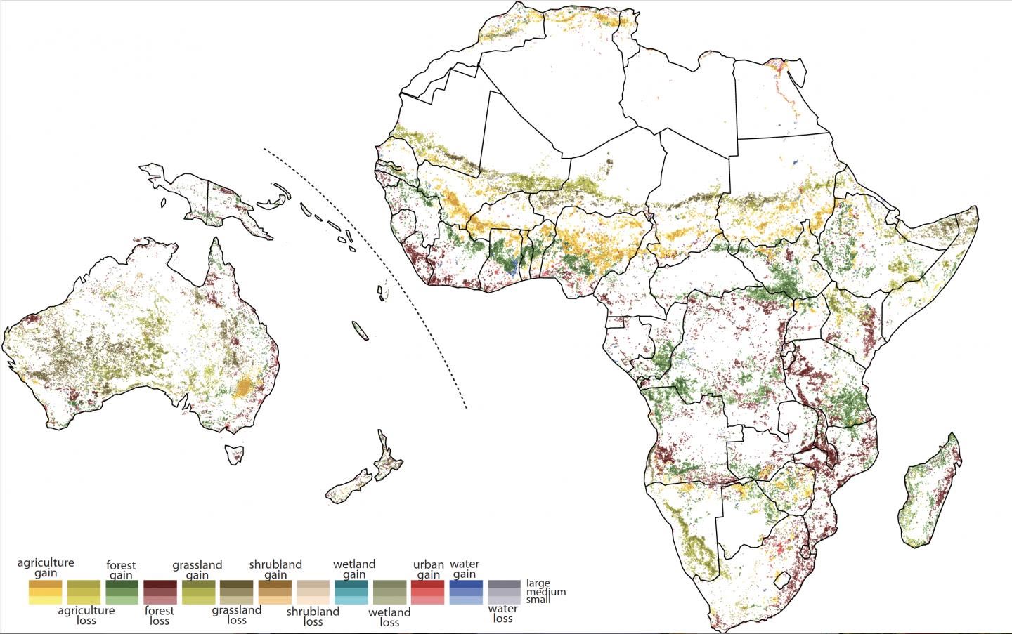
Global satellite imagery shows transitions occur quickly after blocks of forest are cut in half.
University of Cincinnati geography researchers have identified a tipping point for deforestation that leads to rapid forest loss.
Geography professor Tomasz Stepinski used high-resolution satellite images from the European Space Agency to study landscapes in 9-kilometer-wide blocks across every inch of the planet between 1992 and 2015. He found that deforestation occurs comparatively slowly in these blocks until about half of the forest is gone. Then the remaining forest disappears very quickly.
The study was published in the journal Geophysical Research Letters.
The project by Stepinski’s Space Informatics Lab demonstrates UC’s commitment to research as outlined in its strategic direction called Next Lives Here.
Stepinski and former UC postdoctoral researcher Jakub Nowosad, the lead author, discovered something surprising and fundamental: nature abhors mixed landscapes, at least on a scale of 81 square kilometers. The study showed that mixed landscapes (like agriculture and forest) are comparatively few and, more surprisingly, do not stay mixed for long. These mixed blocks tend to become homogeneous over time, regardless of the landscape type.
“I think it’s very intuitive. It corresponds to the different climatic zones. The Earth before people was certainly like that. You had forests and mountains and wetlands and deserts,” Stepinski said. “You would expect people would create more fragmentation, but as it turns out, people never stop. They convert the entire block on a large scale.”
Stepinski said landscapes are always changing through natural or anthropological causes. Human causes are both direct, like clear-cutting, or indirect like climate change.
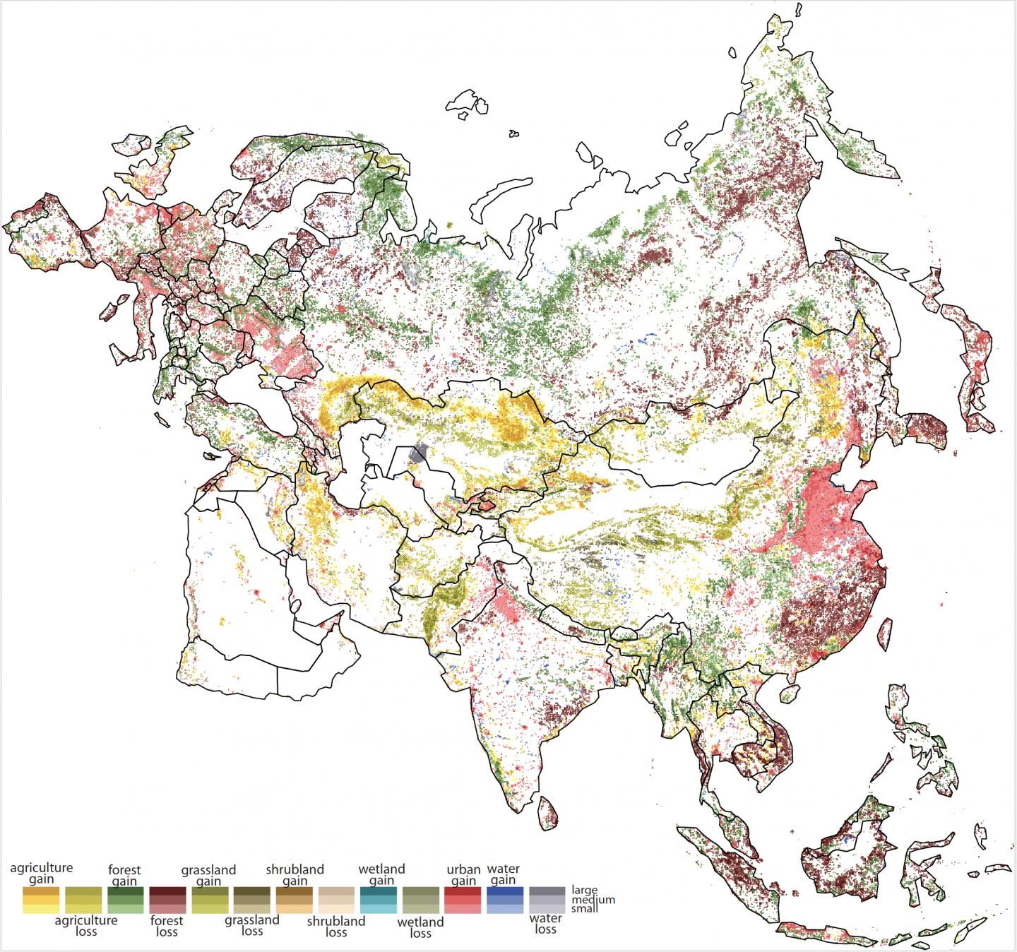
Last year, Stepinski used the same data to demonstrate that 22% of the Earth’s habitable surface was altered in measurable ways between 1992 and 2015. The biggest change: forest to agriculture.
For the new study, Stepinski examined nearly 1.8 million blocks covering Earth’s seven continents. Blocks were categorized by 64 landscape combinations. Researchers observed transitions in these blocks from predominantly one type to predominantly another in nearly 15% of the blocks between 1992 and 2015.
“The data we have covers 23 years. That’s a relatively short period of time. But from that we can calculate change in the future,” Stepinski said.
Deforestation was the most pronounced example of human-caused landscape change, researchers found. They used probability modeling known as Monte Carlo methods to determine the likelihood of different types of landscape change over time (in this case hundreds of years).
The result? Researchers found that the most likely trajectory of change was from one homogeneous type to another.
“Planet Earth wants to be homogeneous. The land wants to be the same in all these patches. And when they start to change, they don’t stop until they convert everything into another homogeneous block,” he said.
The authors did not examine why blocks change so quickly once a transition begins. But Stepinski said it’s possible that development such as logging roads or drainage required to clear forest makes continued change that much easier.
“I can only speculate because that was not part of the study, but I would imagine two things are happening,” he said. “If you are cutting forest, you have the infrastructure to finish it. It’s so much easier to cut the rest. Second, the forest is more vulnerable to change when there has been a disturbance.”
Wildlife managers often try to preserve larger intact blocks to prevent fragmentation, said Martin McCallister, the Appalachian Forest project manager for the Edge of Appalachia Nature Preserve in southern Ohio. The preserve is managed by the Nature Conservancy, one of the world’s largest wildlife conservation organizations.
“You’d be hard-pressed to find land managers who wouldn’t be strongly in favor of protecting larger tracts because they’re more resilient to a variety of challenges, including invasive species and climate change,” McCallister said. “Once a property gets fragmented by roads, it’s easier to extract resources. It’s also easier for invasive species and pests to get a foothold.”
McCallister said woodlands can be fragmented on paper, too.
“In Ohio, 96 percent of our woodland owners have less than 50 acres. They represent a lot of small parcels,” he said.
At 20,000 acres, the Edge of Appalachia is the largest nature preserve in Ohio. The first prairie there was protected in the 1950s after extensive lobbying by the late UC botanist E. Lucy Braun. McCallister said Braun left a lasting legacy of conservation in southern Ohio.
“It shows how one person can make a big difference,” McCallister said.
The UC study found that mixed land types don’t stay mixed for long.
“I think it is interesting that this property applies both to natural and human landscapes,” said co-author Nowosad, a former UC postdoctoral researcher who now works as an assistant professor at the Adam Mickiewicz University in Poland.
Nowosad said the study provides a data-driven model of long-term landscape change. While researchers only looked at changes between forest and agriculture, Nowosad said it would be worthwhile to examine whether tipping points exist for other landscape transitions.
“This model can be used to help understand how landscapes evolved and are going to evolve in the future,” Nowosad said.
Stepinski, a physicist who worked for NASA before coming to UC, said the principle borrows from other disciplines, particularly astrophysics.
“If you look at the evolution of stars, the principle is you predict a long-term path statistically from short-term knowledge,” Stepinski said. “It’s an idea that has been used elsewhere but never for environmental study.”
While it’s only a theory, it’s one that could be borne out by time, he said.
“It’s thought-provoking. My hope is that people will critique it and come up with different ideas,” Stepinski said.
Reference: “Stochastic, Empirically Informed Model of Landscape Dynamics and Its Application to Deforestation Scenarios” by J. Nowosad and T. F. Stepinski, 3 December 2019, Geophysical Research Letters.
DOI: 10.1029/2019GL085952
Never miss a breakthrough: Join the SciTechDaily newsletter.
Follow us on Google and Google News.