Close Menu
    Facebook X (Twitter) Instagram
    SciTechDaily
    • Biology
    • Chemistry
    • Earth
    • Health
    • Physics
    • Science
    • Space
    • Technology
    Facebook X (Twitter) Pinterest YouTube RSS
    SciTechDaily
    Home»Earth»Unmanned Aerial Vehicles and Harmless Dyes Shed Light on Coastal Water Flows
    Earth

    Unmanned Aerial Vehicles and Harmless Dyes Shed Light on Coastal Water Flows

    By King Abdullah University of Science & Technology (KAUST)March 17, 2022No Comments3 Mins Read
    Facebook Twitter Pinterest Telegram LinkedIn WhatsApp Email Reddit
    Share
    Facebook Twitter LinkedIn Pinterest Telegram Email Reddit
    Drones Shed Light on Coastal Water Flows
    Unmanned aerial vehicles and harmless dyes can be used to monitor the movement of water between habitats along the Red Sea coast. Credit: © 2022 KAUST

    Unmanned aerial vehicles show promise for monitoring coastal water flows over large areas.

    Runoff in coastal waters is linked to pollution and degradation of coral reefs and other marine ecosystems. Unmanned aerial vehicles (UAVs) have now been used to overcome the challenges of monitoring water flow between ecosystems and over large areas.

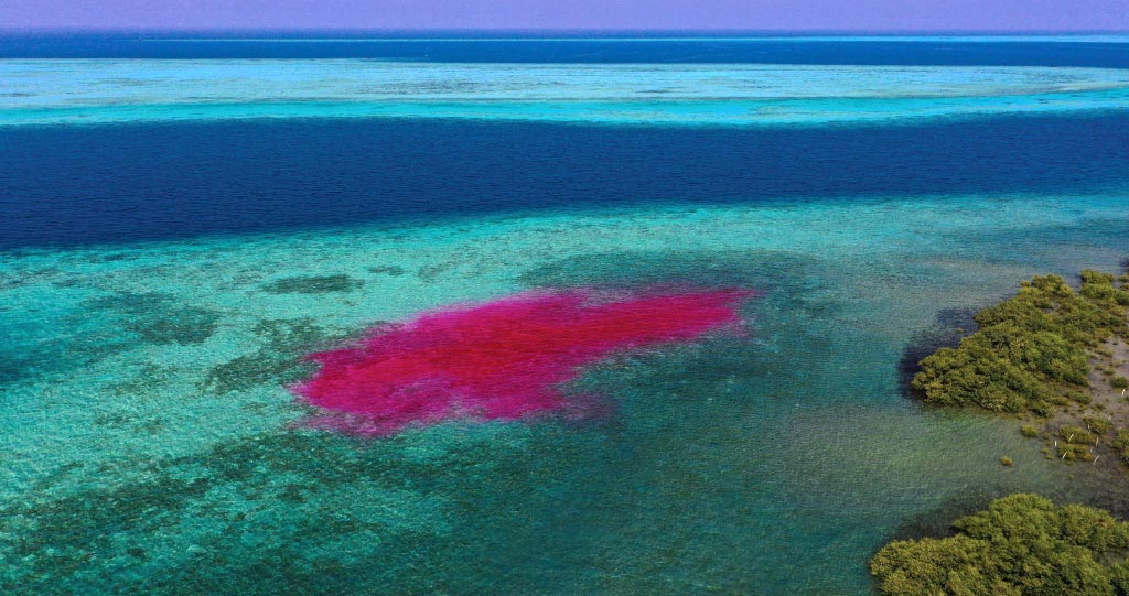
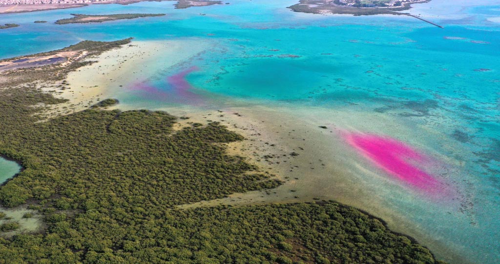
    High-frequency hovering UAV images and flight surveys were used by KAUST researchers to track the movement of dye plumes released during an ebbing tide. Led by remote sensing researcher Kasper Johansen, the team also used information from aerial images combined with field measurements to map dye concentrations, providing insights into the dispersion of materials in the water column and along the coast.

    Unmanned Aerial Vehicles Shed Light on Coastal Water Flows
    The method represents a more accessible and cost-effective way to monitor the flow of pollutants or nutrients along coastlines or between marine habitats. Credit: © 2022 KAUST

    Techniques for Tracing Dye Plumes

    To enable continuous tracing of the dye plumes, two drones hovered for 80 minutes above the seagrass and mangrove locations where the dye was released, collecting photos every 10 seconds and providing full coverage of the plumes. UAV flight surveys then collected data as the plumes spread over a larger area.

    Field-based dye concentration measurements were related to the pixel values of spectral bands and indices of 30 different UAV photos. These were collected at the precise time of each collected seawater sample to produce a relationship that could be used to map dye concentrations for the duration of the ebbing tide.

    Johansen says the information obtained can provide insights into the exchange, transportation, and dependencies of nutrients between mangrove, seagrass, and coral reef ecosystems.

    “With new high spatial resolution satellite constellations becoming available and allowing sub-daily image collection, satellite-based dye-tracing experiments may be accomplished for much larger areas, with UAV data potentially bridging the gaps between field measurements and satellite image data,” he says.

    UAVs Shed Light on Coastal Water Flows
    The movement of oil spills or sewage runoff can be closely monitored, helping to reduce their impact on precious marine resources. Credit: © 2022 KAUST

    Understanding the dynamics and exchanges of water and nutrients along the coastal fringe is important for numerous research efforts at KAUST.

    Director of KAUST’s Climate and Livability Initiative Matthew McCabe says the study has demonstrated the capacity of new Earth observation techniques for monitoring time-sensitive events and capturing rapidly developing processes.

    “These technologies can be deployed to support some of the large-scale projects going on within Saudi Arabia,” he says.

    Future studies could monitor coastal water flows in different environmental settings, for example, with larger tidal ranges or deeper water. The method could also help predict where pollutants such as sewage, river runoff, or oil spills will be transported along the coast.

    Cost-Effective Coastal Monitoring

    “The study represents a lower cost way to visualize coastal water flows,” says Aislinn Dunne, a marine scientist on the team. “UAVs are becoming increasingly available to scientists and private citizens, so this method offers a more accessible and cost-effective way for regular monitoring of coastal water movement.”

    Reference: “Dye tracing and concentration mapping in coastal waters using unmanned aerial vehicles” by Kasper Johansen, Aislinn F. Dunne, Yu-Hsuan Tu, Samir Almashharawi, Burton H. Jones and Matthew F. McCabe, 21 January 2022, Scientific Reports.
    DOI: 10.1038/s41598-022-05189-9

    Never miss a breakthrough: Join the SciTechDaily newsletter.
    Follow us on Google and Google News.

    Ecology KAUST
    Share. Facebook Twitter Pinterest LinkedIn Email Reddit

    Related Articles

    Algorithm for Algal Rhythms: Red Sea Atlas of Algal Blooms Reveals the Need for More Sustainable Fish Farming

    New Chinese Survey Reveals Extensive Coastal Pollution

    Study Looks at the Role of Climate Change in Extinction

    Carbon Absorption by Plants Limited by the Abundance of Soil Nutrients

    Survey of Brazil’s Atlantic Forests Reveals Loss of Key Species

    Nitrogen Pollution Is Altering Sensitive Ecosystems

    Preserving Biodiversity When Agricultural Production Increases

    Evidence Suggests that Earth May Be Headed Toward an Irreversible Change in the Biosphere

    Earth Recovered 10 Million Years After Permian-Triassic Mass Extinction

    Leave A Reply Cancel Reply

    • Facebook
    • Twitter
    • Pinterest
    • YouTube

    Don't Miss a Discovery

    Subscribe for the Latest in Science & Tech!

    Trending News

    Doctors May Need To Rethink Calcium and Vitamin D Recommendations After Major Review

    Scientists Discover a Hidden Cause of Cellular Aging That Can Be Reversed

    Archaeologists Have Found Something Unexpected Inside a 1,600-Year-Old Egyptian Mummy

    Scientists May Have Found a Completely New Way To Treat Depression

    New 7-Dimensional Theory May Finally Solve the Black Hole Information Paradox

    Scientists Made Older Mice Biologically Younger Using Gut Microbes

    Scientists Finally Uncover Why Ozempic Stops Working for Some People

    Wasp Colonies Explode Into Violence After Losing Their Queen

    Follow SciTechDaily
    • Facebook
    • Twitter
    • YouTube
    • Pinterest
    • Newsletter
    • RSS
    SciTech News
    • Biology News
    • Chemistry News
    • Earth News
    • Health News
    • Physics News
    • Science News
    • Space News
    • Technology News
    Recent Posts
    • Scientists May Have Finally Solved the Mystery of the Strange Hum Heard Around the World
    • Researchers Measured Alien Planet Spins and Discovered a Surprising Pattern
    • NASA’s Roman Telescope Will Search 100 Million Stars for New Worlds
    • A Cannibal Star Finally Solves One of Astronomy’s Biggest Mysteries
    • Researchers Solve the Mystery Behind a Billion-Dollar Dental Implant Disease
    Copyright © 1998 - 2026 SciTechDaily. All Rights Reserved.
    • Science News
    • About
    • Contact
    • Editorial Board
    • Privacy Policy
    • Terms of Use

    Type above and press Enter to search. Press Esc to cancel.