Southern Poland’s farmlands don’t conform to the rigid grids seen elsewhere. Instead, they form a mesmerizing patchwork of narrow, ribbon-like fields that evolved over centuries.
Shaped by historical land divisions, the need for road access, and even natural topography, these striking formations are similar to those found in Germany and North America.
Poland’s Unique Agricultural Patterns
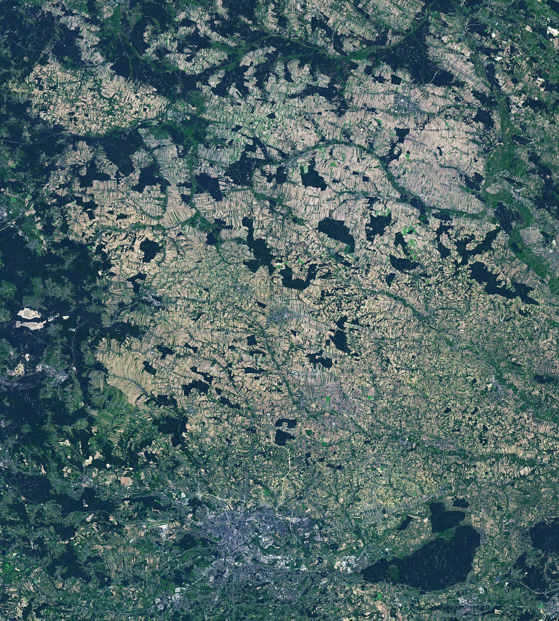
From space, farmlands often appear as neatly arranged grids or circles. But in southern Poland, agriculture took a different path. Over centuries, communities formed along rivers and roads, clearing forests for farmland. As land was passed down through generations, it was divided into long, narrow strips—some only a few meters wide—creating a striking striped pattern that appears both chaotic and structured.
A satellite image captured by the OLI-2 (Operational Land Imager-2) on Landsat 9 in August 2024 highlights this unique landscape around Sułoszowa, a village of approximately 5,500 people located 25 kilometers (15 miles) northwest of Kraków. The image reveals a patchwork of ribbon-like fields radiating from a central road lined with homes. Similar clusters of narrow fields extend from other linear settlements, interspersed with dark green patches of forest, adding to the region’s distinct agricultural pattern.

Echoes of European and North American Settlements
This pattern of rural development bears similarity to the Waldhufendörfer, or “forest villages,” in Germany, where strips of land extend from houses near roads or streams. Likewise, the pattern manifests as tracts of “long lots” in parts of North America that were influenced by French settlers.
This style of farming began developing in Poland around the turn of the 17th century. Settlements were established along streams and roads that generally paralleled the streams. Each settler had a similar area of land about 400 meters (1,300 feet) wide, on average, with access to the road and water.
Land Division and the Evolution of Narrow Fields
Decrees in the 18th and 19th centuries allowed peasants to pass land down to their children, said Michigan State University geographer Arika Ligmann-Zielinska, leading to continual partitioning of the land. “Since access to roads was critical for cultivating farmland, the parcels had to be connected to the roads, enforcing a stripe-like pattern from wider to narrower plots,” she said.

The Role of Rivers, Roads, and Rolling Terrain
Elongated plots tend to run perpendicular to a river or road, and boundaries were set as precisely as possible in the early days. However, before geodetic surveys could plot out perfectly straight lines, fields sometimes took on an arced shape. Clusters of both arced and straight fields occur in the wider area around Sułoszowa (above).
In some places, contours of rolling topography governed the configuration of fields. This appears to have been the case in Sułoszowa, said Cezary Kabała, a soil scientist at Wroclaw University. When Kabała compared the field patterns to a digital terrain model for the village, it revealed how the shapes of the fields largely followed the relief of the hills and gullies.
NASA Earth Observatory images by Lauren Dauphin, using Landsat data from the U.S. Geological Survey.
Never miss a breakthrough: Join the SciTechDaily newsletter.
Follow us on Google and Google News.