Close Menu
    Facebook X (Twitter) Instagram
    SciTechDaily
    • Biology
    • Chemistry
    • Earth
    • Health
    • Physics
    • Science
    • Space
    • Technology
    Facebook X (Twitter) Pinterest YouTube RSS
    SciTechDaily
    Home»Technology»Atmospheric River Observatories Allow Accurate Weather Prediction of Floods
    Technology

    Atmospheric River Observatories Allow Accurate Weather Prediction of Floods

    By SciTechDailyJanuary 3, 2013No Comments3 Mins Read
    Facebook Twitter Pinterest Telegram LinkedIn WhatsApp Email Reddit
    Share
    Facebook Twitter LinkedIn Pinterest Telegram Email Reddit
    Mobile AR Observatory. Credit: NOAA
    Mobile AR Observatory. Credit: NOAA

    Atmospheric rivers are long, narrow conveyor belts of rainstorms that stream in from the Pacific Ocean. Meteorologists have been able to predict the storms five days in advance, thanks to a new network of weather sensors recently installed in California.

    The network is only partially complete, and will be finished in 2014. It should allow the forecast of upcoming storms and floods with much greater precision, and provide a model warning system for flooding.

    Atmospheric rivers flow at about 1.5 kilometers (about 1 mile) above the ocean surface, and extend thousands of miles out to sea, carrying as much water as 15 Mississippi Rivers. It strikes a coast as a series of storms, which arrive for days or weeks on end. Each storm dumps centimeters of rain or meters of snow. Meteorologists had difficulty predicting the amount of precipitation, and therefore possible flooding. Satellite radars that track airborne water vapor over the ocean do well there, but have trouble tracking it over land.

    The NOAA, speaking at the American Geophysical Union conference last December, stated that satellites do not give a good assessment of winds within the corridor of water vapor, which affects how quickly they move rain inland.

    The amount of flooding is strongly influenced by how wet or dry a region’s soil is before or during the storms, which can only be measured by sensors embedded directly in the ground. Rain causes more immediate flooding whereas snow may cause delayed flooding.

    Snow radars are being deployed in 10 major watersheds. Soil moisture sensors are being installed at 43 sites across California, which will allow the prediction if an incoming storm will produce heavy runoff. Some of the snow radars and three-quarters of the soil sensors are already in place.

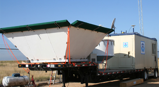
    The four unique atmospheric river observatories, located about 400 km from one another, are about the size of a dump truck, look upward and show precise wind speed and direction at several altitudes, the total amount of water vapor above the site, and the elevation at which precipitation is rain or snow.

    On November 23, the system proved its worth, allowing forecasters to predict five days in advance that an atmospheric river would begin plummeting the state. Storms started hitting the coast on November 28 and lasted 5 days, dumping up to 38 cm (15 in) of rain, causing flooding and mudslides. Forecasters used the information to warn residents about which rivers might flood, and when. California’s Department of Water Resources used the data to decide whether to mitigate flooding by opening or closing dams and other structures along the state’s rivers.

    Never miss a breakthrough: Join the SciTechDaily newsletter.
    Follow us on Google and Google News.

    Meteorology NOAA Weather
    Share. Facebook Twitter Pinterest LinkedIn Email Reddit

    Related Articles

    Scientists Discover Potential Key to Predicting Hurricanes Weeks in Advance

    Antarctica Is Undergoing a “Regime Shift” – New Research Uncovers Fundamental Changes in Polar Climates

    NOAA’s Updated Outlook Warns of Above-Normal Activity for 2023 Atlantic Hurricane Season

    Revolutionary Technology Provides New Perspective on Cyclones

    Startling Consequences of Global Warming: Oceans Are Losing Their Memory

    Massive Flying Laboratory Uncovers Secrets of How Marine Life Influences Cloud Formation

    Stunning NASA Image Captures Tropical Storm Ida at It Passes Over the Southern U.S.

    New NASA/NOAA Animations Reveal Water Vapor Over Oceans

    Commercial Network of Microsatellites Aims to Help Weather Prediction

    Leave A Reply Cancel Reply

    • Facebook
    • Twitter
    • Pinterest
    • YouTube

    Don't Miss a Discovery

    Subscribe for the Latest in Science & Tech!

    Trending News

    Millions Take These IBS Drugs, But a New Study Finds Serious Risks

    Scientists Unlock Hidden Secrets of 2,300-Year-Old Mummies Using Cutting-Edge CT Scanner

    Bread Might Be Making You Gain Weight Even Without Eating More Calories

    Scientists Discover Massive Magma Reservoir Beneath Tuscany

    Europe’s Most Active Volcano Just Got Stranger – Here’s Why Scientists Are Rethinking It

    Alzheimer’s Symptoms May Start Outside the Brain, Study Finds

    Millions Take This Popular Supplement – Scientists Discover a Concerning Link to Heart Failure

    The Universe Is Expanding Too Fast and Scientists Can’t Explain Why

    Follow SciTechDaily
    • Facebook
    • Twitter
    • YouTube
    • Pinterest
    • Newsletter
    • RSS
    SciTech News
    • Biology News
    • Chemistry News
    • Earth News
    • Health News
    • Physics News
    • Science News
    • Space News
    • Technology News
    Recent Posts
    • Doctors Surprised by the Power of a Simple Drug Against Colon Cancer
    • Why Popular Diabetes Drugs Like Ozempic Don’t Work for Everyone: The “Genetic Glitch”
    • Scientists Create Improved Insulin Cells That Reverse Diabetes in Mice
    • Scientists Stunned After Finding Plant Thought Extinct for 60 Years
    • A Common Diabetes Drug May Hold the Key to Stopping HIV From Coming Back
    Copyright © 1998 - 2026 SciTechDaily. All Rights Reserved.
    • Science News
    • About
    • Contact
    • Editorial Board
    • Privacy Policy
    • Terms of Use

    Type above and press Enter to search. Press Esc to cancel.