
This image from ESA’s Mars Express shows craters, valleys, and chaotic terrain in Mars’ Pyrrhae Regio. This image comprises data gathered by ESA’s Mars Express using its High Resolution Stereo Camera (HRSC) on August 3, 2020 (orbit 20972). The ground resolution is approximately 16 m/pixel and the images are centered at about 322°E/16°S. This image was created using data from the nadir and color channels of the HRSC. The nadir channel is aligned perpendicular to the surface of Mars, as if looking straight down at the surface. North is to the right. Credit: ESA/DLR/FU Berlin, CC BY-SA 3.0 IGO
Elevation can be deceiving in satellite imagery of Mars, even when differences are extreme – as demonstrated by this image of Pyrrhae Regio from ESA’s Mars Express. A chunk of terrain has collapsed and dropped more than four kilometers below its surroundings, illustrating the incredible contrast and dynamism seen across the Martian surface.
This slice of Mars, seen here as imaged by Mars Express’ High Resolution Stereo Camera (HRSC), shows signs of various intriguing processes.
A scattering of impact craters, formed as incoming bodies from space collided with Mars’ surface, can be seen to the left of the frame; the floor of the largest and uppermost basin spans about 40 kilometers (25 miles), and contains some fractures and markings that formed just after the crater itself. Hot, molten rock is thought to have been thrown up during the crater-forming collision, after which it cooled and settled to form the scar-like features visible here.

This image provides a perspective view of chaotic terrain in Mars’ Pyrrhae Regio. Chaotic terrain forms as a shifting subsurface layer of melting ice and sediment causes the surface above to collapse. Credit: ESA/DLR/FU Berlin, CC BY-SA 3.0 IGO
Towards the middle of the frame, the surface is relatively smooth and featureless – however, two broad channels have worked their way through the landscape, and can be seen as meandering, branching indentations in the surrounding terrain. These channels are reminiscent of so-called ‘sapping valleys’ on Earth, which form as water consistently seeps and flows through sediment to carve out a natural drainage network.
The valleys are attached at their rightward end to the real star of this image: a sunken, uneven, scarred patch of ground known as chaotic terrain.
Chaotic terrain, as the name suggests, looks irregular and jumbled, and is thought to form as sub-surface ice and sediment begins to melt and shift. This shifting layer causes the surface above to collapse – a collapse that can happen quickly and catastrophically as water drains away rapidly through the regolith (the near-surface layer of rocky planets). Ice can be triggered to melt by heating events such as volcanic lava flows, subsurface magmatism, impacts by large meteorites, or changes in climate.
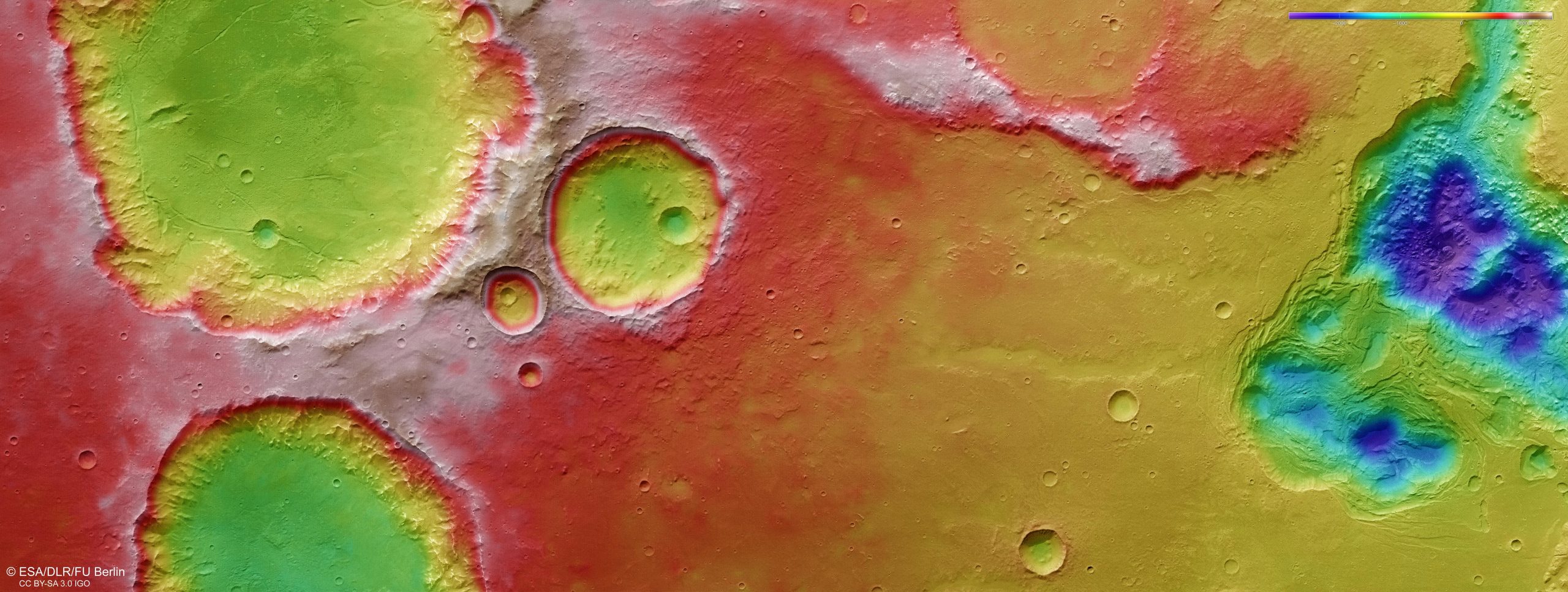
This color-coded topographic image shows craters, valleys, and chaotic terrain in Mars’ Pyrrhae Regio, based on data gathered by the Mars Express High Resolution Stereo Camera (HRSC) during orbit 20972 (August 3, 2020). This view is based on a digital terrain model (DTM) of the region, from which the topography of the landscape can be derived; lower parts of the surface are shown in blues and purples, while higher altitude regions show up in whites, yellows, and reds, as indicated on the scale to the top right. North is to the right. Credit: ESA/DLR/FU Berlin, CC BY-SA 3.0 IGO
In the chaotic terrain seen here, ice has melted, the resulting water drained away, and a number of disparate broken ‘blocks’ have been left standing in now-empty cavities (which once hosted ice). Remarkably, the floors of these cavities lie some four kilometers (2.5 miles) below the flatter ground near the craters to the left, as seen clearly in the associated topographic view – a colossal difference in height (for reference, the highest mountain peaks of the Pyrenees and the Alps top out at just over 3.4 km (2.1 mi) and 4.8 km (3 mi), respectively).
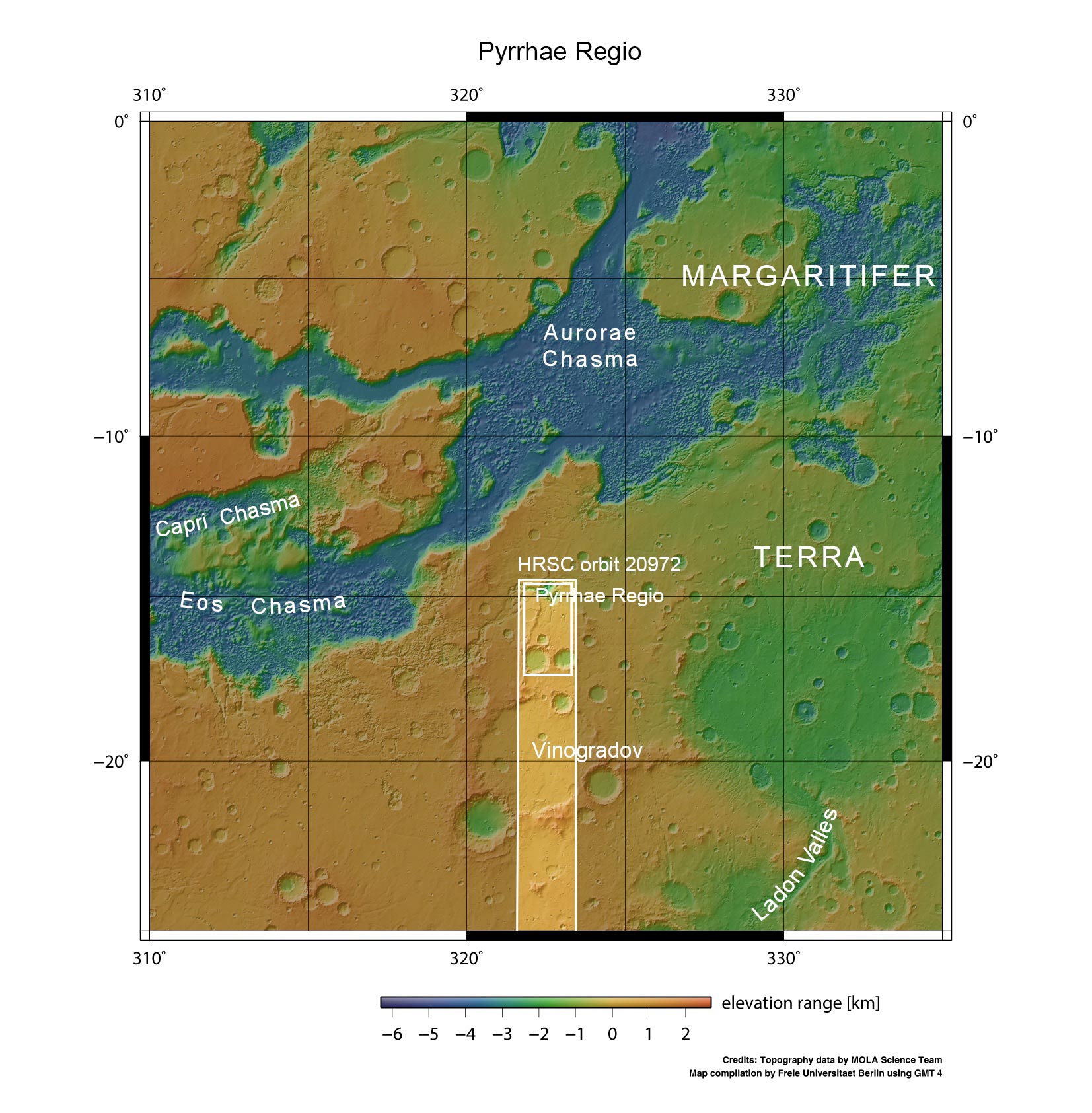
This image from ESA’s Mars Express shows Mars’ Pyrrhae Regio in wider context. The area outlined by the bold white box indicates the area imaged by the Mars Express High Resolution Stereo Camera (HRSC) on August 3, 2020, during orbit 20972. Credit: NASA MGS MO-LA Science Team
Considering the broader landscape containing and surrounding Pyrrhae Regio, the chaotic nature of this area is unsurprising. To the west of this patch of ground lies one of the most extreme features in the Solar System: a colossal canyon system named Valles Marineris.
Valles Marineris is roughly ten times longer and five times deeper than the Grand Canyon on Earth, and comprises myriad smaller rifts, channels, outflows, fractures, and signs of flowing material (such as water, ice, lava, or debris). It is home to many substantial chaotic terrains, including Aurorae Chaos and Erythraeum Chaos.
Valles Marineris is an unmissable scar on the face of Mars, and thought to have formed as the planet’s crust was stretched by nearby volcanic activity, causing it to rip and crack open before collapsing into the deep troughs we see today. These troughs have been further shaped and eroded by water flows, landslides, and other erosive processes, with spacecraft including Mars Express spying signs that water existed in parts of Valles Marineris in the relatively recent past (‘mere’ hundreds of millions of years ago).

This image shows craters, valleys, and chaotic terrain in Mars’ Pyrrhae Regio in 3D when viewed using red-green or red-blue glasses. This anaglyph was derived from data obtained by the nadir and stereo channels of the High Resolution Stereo Camera (HRSC) on ESA’s Mars Express during spacecraft orbit 20972 (August 3, 2020). It covers a part of the Martian surface centered at 322°E/16°S. North is to the right. Credit: ESA/DLR/FU Berlin, CC BY-SA 3.0 IGO
As well as characterizing the complex processes at play in standout features such as Valles Marineris, Mars Express – in orbit around the Red Planet since December of 2003 – has spent years imaging Mars’ surface, mapping its minerals, identifying the composition and circulation of its tenuous atmosphere, probing beneath its crust, and exploring how phenomena such as the solar wind, a stream of charged particles emanating from the Sun, interacts in the martian environment.


Be the first to comment on "Creating Chaos: Craters, Cracks, and Collapse on Mars"