Several cities on the west coast of Florida lost much of their electric power for days after the storm.
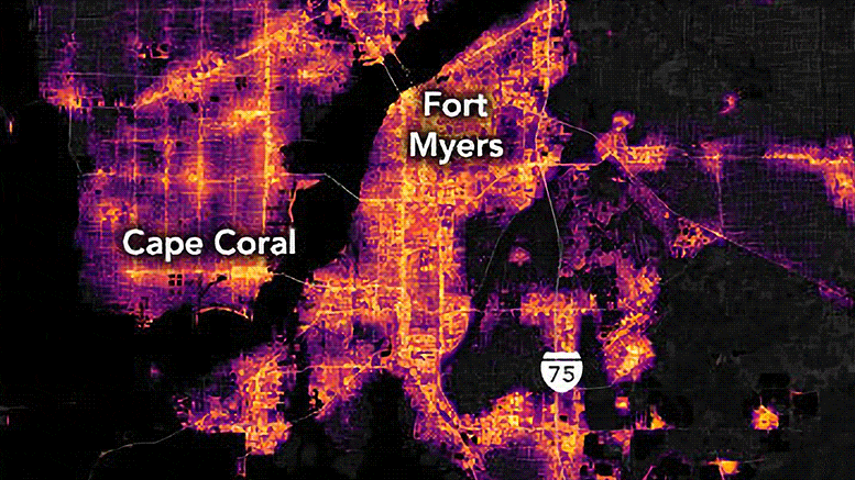
Hurricane Ian roared across Florida over September 28–29, 2022, as one of the most powerful storms ever to make landfall in the state. The category-4 hurricane hit the southwestern coast of Florida with several feet of storm surge, backed by sustained winds of 150 miles (240 kilometers) per hour, before dumping more than a foot of rain in wide swaths across the state.
Millions of residential and business customers lost electric power and light in the hours after the storm passed. The Visible Infrared Imaging Radiometer Suite (VIIRS) on the NOAA–NASA Suomi NPP satellite captured views of some of those losses as they appeared on September 30, 2022.
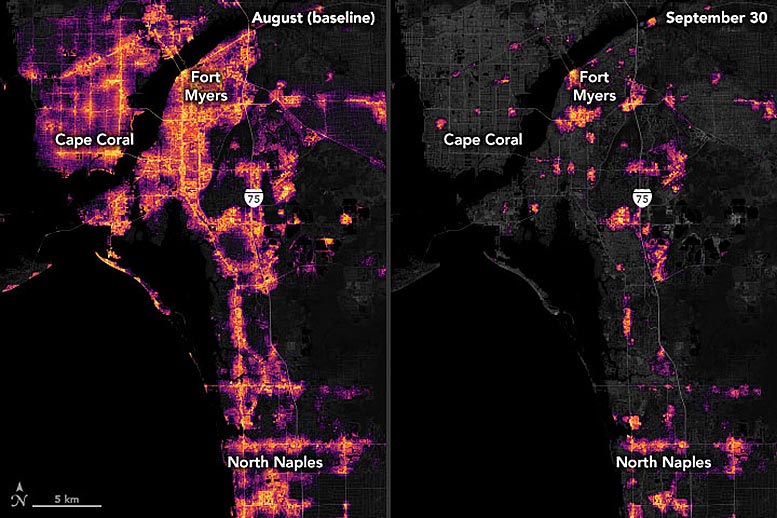
Among the worst-hit communities were Fort Myers and Bradenton/Sarasota. The images above and below focus on the metropolitan areas of these cities. VIIRS has a low-light sensor—the day-night band—that measures nighttime light emissions and reflections. Scientists with the Black Marble Project at NASA’s Goddard Space Flight Center, Science Systems and Applications, Inc. (SSAI), and the University of Maryland, College Park (UMD) processed VIIRS data to show lights before and after Hurricane Ian passed through the cities. Data from September 30 were compared to a pre-storm composite (August) and overlaid on landcover data collected by Landsat 8 and 9.
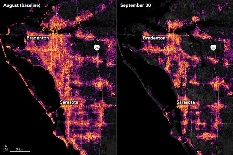
“As disasters often affect an entire region, the ability to capture widespread outages in a distributed energy system is extremely useful for damage assessment,” said Ranjay Shrestha, an SSAI scientist with the Black Marble group. “Combining socioeconomic and population data with nighttime light-derived metrics further helps us understand the interaction between power restoration rates and vulnerable populations.”
According to unofficial estimates, approximately 580,000 of Florida’s 11 million business and residential customers were still without power on the afternoon of October 3, down from about 2.7 million on September 29. Outages were concentrated around Lee, Charlotte, and Sarasota counties in the southwestern part of the state. Thousands of utility workers from 34 states traveled to Florida to help restore power lines and other equipment.
The VIIRS day/night band makes it possible to detect the intensity of lights and observe their variations. Relief agencies sometimes use nighttime imagery to identify areas that are most in need of aid and support. “Our team has been developing standardized approaches for power outage and recovery assessment that aim to assist local communities in improving resilience against the impacts of climate change and extreme weather events,” said Zhuosen Wang, a Black Marble product principal investigator and University of Maryland scientist.
Precision is crucial for studies with night lights. Raw, unprocessed images can be misleading because moonlight, pollution, clouds, seasonal vegetation—even the position of the satellite—can change how light is reflected and can distort observations. The processing by the Black Marble team accounts for such variations and filters out stray light from sources that are not electric lights.
NASA Earth Observatory images by Joshua Stevens, using Black Marble data courtesy of Ranjay Shrestha/NASA Goddard Space Flight Center, Landsat data from the U.S. Geological Survey, and data from OpenStreetMap.
Never miss a breakthrough: Join the SciTechDaily newsletter.
Follow us on Google and Google News.