Close Menu
    Facebook X (Twitter) Instagram
    SciTechDaily
    • Biology
    • Chemistry
    • Earth
    • Health
    • Physics
    • Science
    • Space
    • Technology
    Facebook X (Twitter) Pinterest YouTube RSS
    SciTechDaily
    Home»Earth»Gorgeous Watercolor Seas in the Wake of Hurricane Ian
    Earth

    Gorgeous Watercolor Seas in the Wake of Hurricane Ian

    By Kathryn Hansen, NASA Earth ObservatoryOctober 9, 20221 Comment2 Mins Read
    Facebook Twitter Pinterest Telegram LinkedIn WhatsApp Email Reddit
    Share
    Facebook Twitter LinkedIn Pinterest Telegram Email Reddit
    Watercolor Seas in the Wake of Hurricane Ian
    Florida’s coastal waters in the wake of Hurricane Ian

    Storm-Stirred Sediment Produced Colorful Swirls Along the Western Coast of Florida

    Hurricane Ian barreled into Florida’s southwestern coast on September 28, 2022, as a powerful category-4 storm with sustained winds of about 150 miles (240 kilometers) per hour. However, wind was not the only destructive component of the powerful storm; water was also a major factor, in the form of a catastrophic storm surge, relentless downpours, and intense flooding.

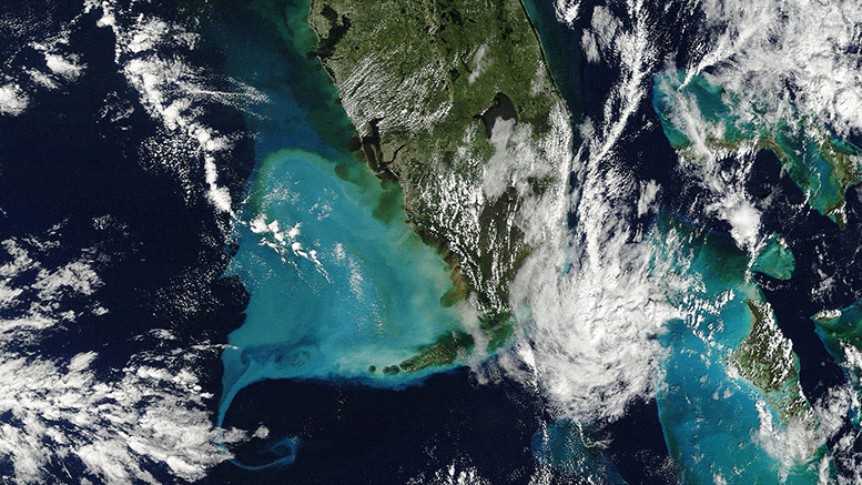
    The redistribution of water is clearly evident in these natural-color satellite images, which show colorful swirls of sediment that the storm stirred up in Florida’s coastal waters. The turquoise color is likely sediment that the storm Ian lifted from the seafloor as it neared the coast. Brown water closer to shore is likely colored by sediment from land, carried by rivers and runoff flowing into the ocean.

    Florida October 2022 Annotated
    October 1, 2022
    Florida September 2022 Annotated
    September 22, 2022

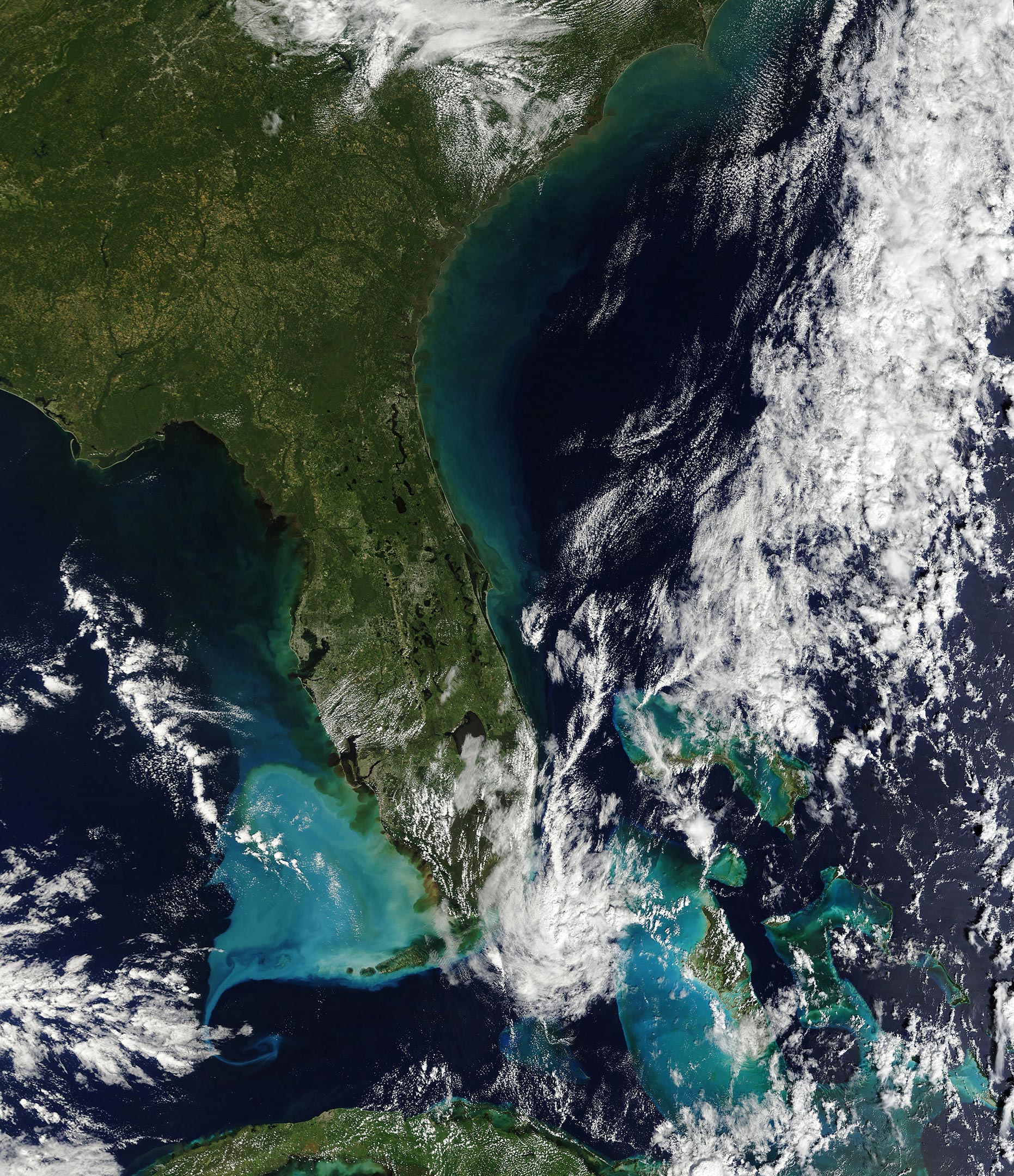
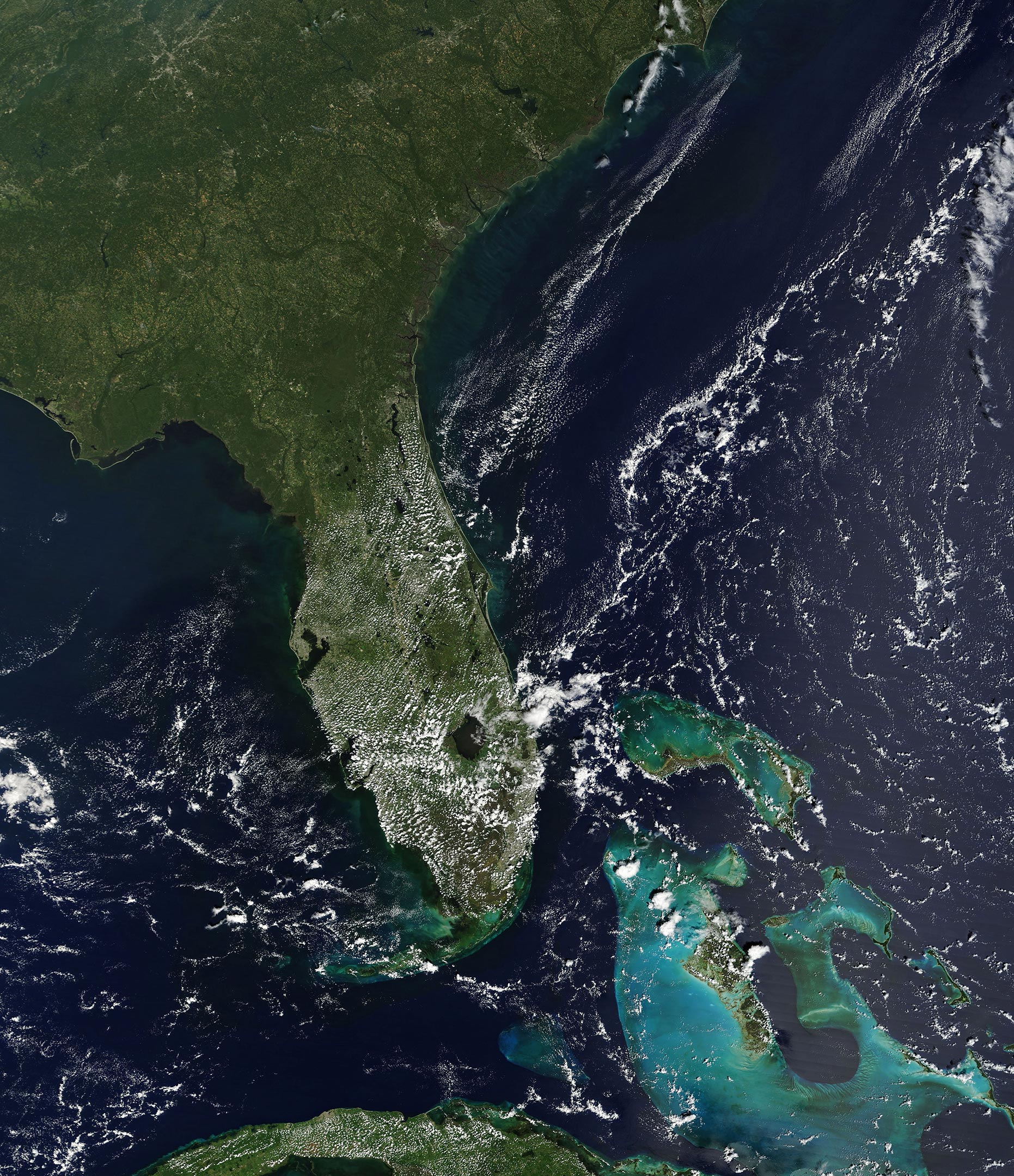
    The image (upper) was acquired by the Moderate Resolution Imaging Spectroradiometer (MODIS) on NASA’s Terra satellite on October 1, 2022, a few days after landfall. For comparison, the second image (lower) shows a more typical view of the region’s coastal waters on September 22, 2022.

    Notice that even before the storm, there is already some color in the water. Although smaller amounts of suspended sediments were likely present, much of the color is actually due to light reflecting off seagrass beds, the sandy seafloor, and coral reefs (especially around the Bahamas). Some of the darkest colors near rivers could be caused by tannins from decaying vegetation.

    Fort Myers September 2022 Annotated
    September 30, 2022

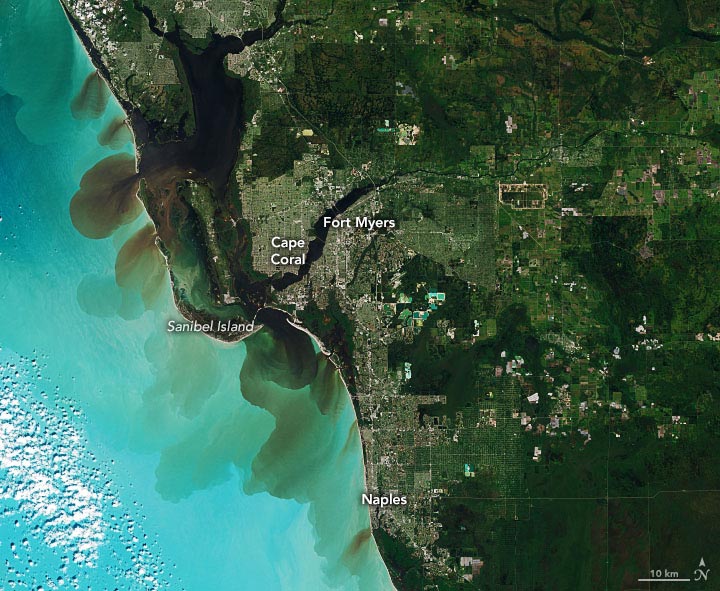
    The image above was acquired by the European Space Agency (ESA)’s Sentinel-2 mission on September 30, 2022. It shows a detailed view of the coastline near Fort Myers, Florida. Parts of this coastline and barrier islands were among some of the hardest hit, with flooding from storm surge that likely measured at least 6 feet (2 meters) deep.

    Almost one week after Hurricane Ian made landfall in Florida, swirls of sediment were still apparent on October 4.

    NASA Earth Observatory images by Joshua Stevens, using MODIS data from NASA EOSDIS LANCE and GIBS/Worldview and modified Copernicus Sentinel data (2022) processed by the European Space Agency.

    Never miss a breakthrough: Join the SciTechDaily newsletter.
    Follow us on Google and Google News.

    Hurricane NASA NASA Earth Observatory Storms Weather
    Share. Facebook Twitter Pinterest LinkedIn Email Reddit

    Related Articles

    Dramatic Satellite Images Show Power Outages After Hurricane Ian

    Fuel for Hurricane Ian: Fearsome Power Comes From the Ocean

    Hurricane Ian Enters the Gulf of Mexico – Headed Toward the West Coast of Florida

    Hurricane Fiona & Typhoon Nanmadol: Powerful Storms Hit Puerto Rico and Japan

    Hurricane Ida Leaves a Trail of Oil in the Gulf of Mexico

    A Changed Landscape in Southern Louisiana After Hurricane Ida: Large New Patches of Open Water

    NASA Satellite Observes Massive Power Outages in New Orleans

    Hurricane Ida Batters Louisiana: 5th-Strongest Storm Ever To Make Landfall in the Continental U.S.

    Incredible View of Tropical Storm Elsa Captured From Space

    1 Comment

    1. Zack on October 10, 2022 9:08 am

      The last image, taken sept 30, shows the brown colored coastline water as a result of the turbulances that stirred up the sediments of landmass from river. How can be the clearly defined rim lines possible under such turbulances?

      Reply
    Leave A Reply Cancel Reply

    • Facebook
    • Twitter
    • Pinterest
    • YouTube

    Don't Miss a Discovery

    Subscribe for the Latest in Science & Tech!

    Trending News

    Millions Take These IBS Drugs, But a New Study Finds Serious Risks

    Scientists Unlock Hidden Secrets of 2,300-Year-Old Mummies Using Cutting-Edge CT Scanner

    Bread Might Be Making You Gain Weight Even Without Eating More Calories

    Scientists Discover Massive Magma Reservoir Beneath Tuscany

    Europe’s Most Active Volcano Just Got Stranger – Here’s Why Scientists Are Rethinking It

    Alzheimer’s Symptoms May Start Outside the Brain, Study Finds

    Millions Take This Popular Supplement – Scientists Discover a Concerning Link to Heart Failure

    The Universe Is Expanding Too Fast and Scientists Can’t Explain Why

    Follow SciTechDaily
    • Facebook
    • Twitter
    • YouTube
    • Pinterest
    • Newsletter
    • RSS
    SciTech News
    • Biology News
    • Chemistry News
    • Earth News
    • Health News
    • Physics News
    • Science News
    • Space News
    • Technology News
    Recent Posts
    • Doctors Surprised by the Power of a Simple Drug Against Colon Cancer
    • Why Popular Diabetes Drugs Like Ozempic Don’t Work for Everyone: The “Genetic Glitch”
    • Scientists Create Improved Insulin Cells That Reverse Diabetes in Mice
    • Scientists Stunned After Finding Plant Thought Extinct for 60 Years
    • A Common Diabetes Drug May Hold the Key to Stopping HIV From Coming Back
    Copyright © 1998 - 2026 SciTechDaily. All Rights Reserved.
    • Science News
    • About
    • Contact
    • Editorial Board
    • Privacy Policy
    • Terms of Use

    Type above and press Enter to search. Press Esc to cancel.