
A new imaging algorithm leverages the rotation of space debris to capture clearer images, helping track hazardous objects in Earth’s orbit more effectively.
Litter is not only a problem on Earth. According to NASA, there are currently millions of pieces of space junk in the range of altitudes from 200 to 2,000 kilometers above the Earth’s surface, which is known as low Earth orbit (LEO). Most of the junk is comprised of objects created by humans, like pieces of old spacecraft or defunct satellites. This space debris can reach speeds of up to 18,000 miles per hour, posing a major danger to the 2,612 satellites that currently operate at LEO. Without effective tools for tracking space debris, parts of LEO may even become too hazardous for satellites.
In a paper publishing on February 25, 2021, in the SIAM Journal on Imaging Sciences, Matan Leibovich (New York University), George Papanicolaou (Stanford University), and Chrysoula Tsogka (University of California, Merced) introduce a new method for taking high-resolution images of fast-moving and rotating objects in space, such as satellites or debris in LEO. They created an imaging process that first utilizes a novel algorithm to estimate the speed and angle at which an object in space is rotating, then applies those estimates to develop a high-resolution picture of the target.
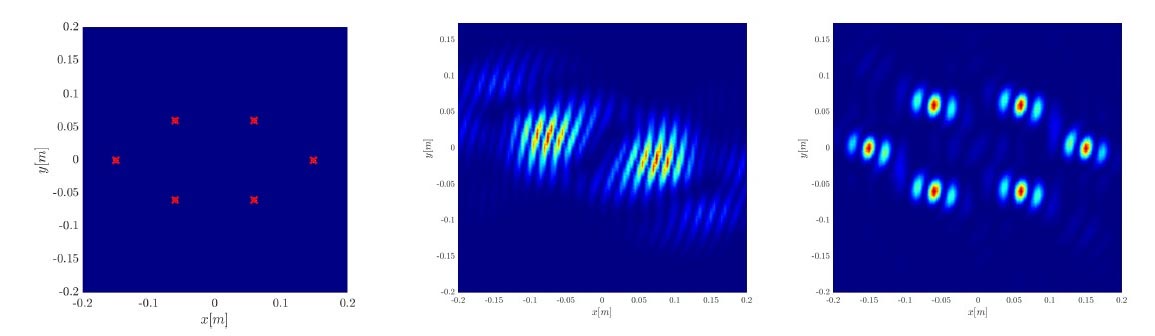
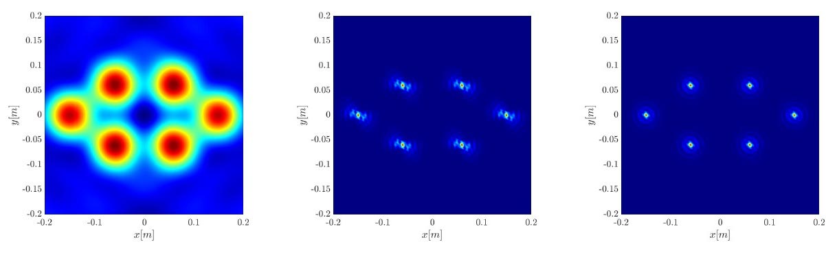
Leibovich, Papanicolaou, and Tsogka used a theoretical model of a space imaging system to construct and test their imaging process. The model depicts a piece of fast-moving debris as a cluster of very small, highly reflective objects that represent the strongly reflective edges of an item in orbit, such as the solar panels on a satellite. The cluster of reflectors all move together with the same speed and direction and rotate about a common center. In the model, multiple sources of radiation on the Earth’s surface—such as the ground control stations of global navigation satellite systems—emit pulses that are reflected by target pieces of space debris. A distributed set of receivers then detects and records the signals that bounce off the targets.
Tackling Signal Distortion and Aperture Limitations
The model focuses on sources that produce radiation in the X-band, or from frequencies of 8 to 12 gigahertz. “It is well known that resolution can be improved by using higher frequencies, such as the X-band,” Tsogka said. “Higher frequencies, however, also result in distortions to the image due to ambient fluctuations from atmospheric effects.” Signals are distorted by turbulent air as they travel from the target to receivers, which can make the imaging of objects in LEO quite challenging. The first step of the authors’ imaging process was thus to correlate the data taken at different receivers, which can help reduce the effects of these distortions.
The diameter of the area encompassed by the receivers is called the physical aperture of the imaging system — in the model, this is about 200 kilometers. Under normal imaging conditions, the physical aperture’s size determines the resolution of the resulting image; a larger aperture begets a sharper picture. However, the quick movement of the imaging target relative to the receivers can create an inverse synthetic aperture, in which the signals that were detected at multiple receivers as the target moved throughout their field of view are synthesized coherently. This configuration can effectively improve the resolution, as if the imaging system had a wider aperture than the physical one.
Object Rotation in Space
Objects in LEO can spin on timescales that range from a full rotation every few seconds to every few hundred seconds, which complicates the imaging process. It is thus important to know—or at least be able to estimate—some details about the rotation before developing the image. The authors therefore needed to estimate the parameters related to the object’s rotation before synthesizing the data from different receivers. Though simply checking all of the possible parameters to see which ones yield the sharpest image is technically feasible, doing so would require a lot of computational power. Instead of employing this brute force approach, the authors developed a new algorithm that can analyze the imaging data to estimate the object’s rotation speed and the direction of its axis.
After accounting for the rotation, the next step in the authors’ imaging process was to analyze the data to develop a picture of the space debris that would hopefully be as accurate and well-resolved as possible. One method that researchers often employ for this type of imaging of fast-moving objects is the single-point migration of cross correlations. Though atmospheric fluctuations do not usually significantly impair this technique, it does not have a very high resolution. A different, commonly-used imaging approach called Kirchhoff migration can achieve a high resolution, as it benefits from the inverse synthetic aperture configuration; however, the trade-off is that it is degraded by atmospheric fluctuations. With the goal of creating an imaging scheme that is not too heavily affected by atmospheric fluctuations but still maintains a high resolution, the authors proposed a third approach: an algorithm whose result they call a rank-1 image. “The introduction of the rank-1 image and its resolution analysis for fast-moving and rotating objects is the most novel part of this study,” Leibovich said.
Comparing Imaging Techniques: Rank-1 vs. Others
To compare the performance of the three imaging schemes, the authors gave simulated data of a rotating object in LEO to each one and compared the images that they produced. Excitingly, the rank-1 image was much more accurate and well-resolved than the result of single-point migration. It also had similar qualities to the output of the Kirchhoff migration technique. But this result was not entirely surprising, given the problem’s configuration. “It is important to note that the rank-1 image benefits from the rotation of the object,” Papanicolaou said. Though a rotating object generates more complex data, one can actually incorporate this additional information into the image processing technique to improve its resolution. Rotation at certain angles can also increase the size of the synthetic aperture, which significantly improves the resolution for the Kirchhoff migration and rank-1 images.
Further simulations revealed that the rank-1 image is not easily muddled by errors in the new algorithm for the estimation of rotation parameters. It is also more robust to atmospheric effects than the Kirchhoff migration image. If receivers capture data for a full rotation of the object, the rank-1 image can even achieve optimal imaging resolution. Due to its good performance, this new imaging method could improve the accuracy of imaging LEO satellites and space debris. “Overall, this study shed light on a new method for imaging fast-moving and rotating objects in space,” Tsogka said. “This is of great importance for ensuring the safety of the LEO band, which is the backbone of global remote sensing.”
Reference: “Correlation Based Imaging for Rotating Satellites” by Matan Leibovich, George Papanicolaou, and Chrysoula Tsogka, 25 February 2021, SIAM Journal on Imaging Sciences.
DOI: 10.1137/20M1357469
Never miss a breakthrough: Join the SciTechDaily newsletter.
Follow us on Google and Google News.
4 Comments
Let’s face it. We are the Pigpen of the solar system.
Could the thermal prospect of space debris creating a layer of insulation contributing to global warming?
Could the thermal prospect of space debris (satellites included) be creating an imposed layer of insulation contributing to global warming?
You realize there is much more space between these pieces of space trash than the picture shows…