Close Menu
    Facebook X (Twitter) Instagram
    SciTechDaily
    • Biology
    • Chemistry
    • Earth
    • Health
    • Physics
    • Science
    • Space
    • Technology
    Facebook X (Twitter) Pinterest YouTube RSS
    SciTechDaily
    Home»Earth»Shocking Satellite Images Reveal Patagonia’s Wildfire Crisis in Unprecedented Detail
    Earth

    Shocking Satellite Images Reveal Patagonia’s Wildfire Crisis in Unprecedented Detail

    By Emily Cassidy, NASA Earth ObservatoryFebruary 13, 20252 Comments3 Mins Read
    Facebook Twitter Pinterest Telegram LinkedIn WhatsApp Email Reddit
    Share
    Facebook Twitter LinkedIn Pinterest Telegram Email Reddit
    Patagonia Magdalena Valley Fire Annotated
    Fires tore through Patagonia in early 2025, fueled by intense heat and strong winds. The Magdalena Valley fire devastated Lanín National Park, while other blazes spread rapidly across Argentina’s forests. (Satellite image of the Magdalena Valley Fire captured on February 9, 2025, by the Operational Land Imager-2 on Landsat 9.)

    Patagonia’s forests burned fiercely in February 2025, with wildfires destroying tens of thousands of hectares in Argentina.

    The Magdalena Valley fire was one of the worst, intensified by scorching heat, strong winds, and low humidity. The fire season, already extreme, was worsened by record-breaking temperatures, and additional fires erupted across the region.

    Fires Ravage Patagonia’s Andean Slopes

    In February 2025, multiple wildfires erupted along the eastern slopes of the Andes Mountains in Patagonia, devastating vast areas of forest. By February 11, the fires had consumed approximately 30,000 hectares (115 square miles) of land in south-central Argentina, forcing hundreds of residents to evacuate, according to news reports.

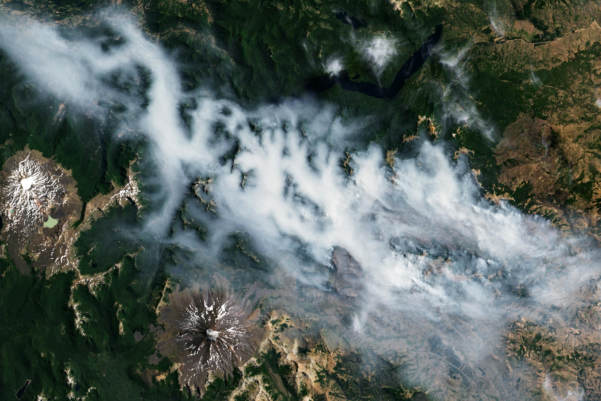
    One of the most intense blazes, the Magdalena Valley fire, was burning in Lanín National Park. NASA’s Aqua satellite captured visible smoke from the fire on February 9 using its MODIS (Moderate Resolution Imaging Spectroradiometer) instrument (image below). A closer view, taken the same day by the OLI-2 (Operational Land Imager-2) on Landsat 9, shows smoke moving through the Magdalena Valley (image above).

    The Magdalena Valley Fire’s Devastation

    The Magdalena Valley fire ignited in late January and had already scorched over 15,000 hectares (58 square miles) of Lanín National Park by February 10. This heavily forested park in Argentina borders Chile’s Villarrica National Park. The two parks are home to the snowcapped, dormant volcanoes Lanín and Quetrupillán, which can be seen in satellite images.

    Fires Rage in Patagonia February 2025 Annotated
    Strong winds and high temperatures fueled summer fires in Argentina. Satellite image captured on February 9, 2025, by the Moderate Resolution Imaging Spectroradiometer instrument on NASA’s Aqua satellite.

    Peak Fire Season: Summer in Patagonia

    The austral summer (December through February) is the dry season in Chile and Argentina when wildfires are more common. This year, strong winds and unusually high temperatures fueled the region’s blazes, which began in December 2024.

    Warm, dry wind from the west crossed the Andes and swept through Lanín National Park at speeds up to 45 kilometers (28 miles) per hour in early February. As the wind flowed down the lee side of the Andes, it compressed, increasing the air temperature and driving down humidity. A similar phenomenon occurs during the Chinook Winds, which flow down the east side of the Rocky Mountains.

    René Garreaud, an atmospheric scientist at the University of Chile, noted that westerly winds crossing the Andes were stronger than average from early January to early February.

    Record Heatwave Fuels the Fires

    Central and northern Argentina were especially hot in January and early February 2025. Maximum temperatures hovered around 35-45 degrees Celsius (95-113 degrees Fahrenheit), which is 3-5°C above normal, according to Argentina’s national weather service. The weather service noted that these “extreme temperatures” were expected to persist in parts of the country until February 12.

    Two other fires burned south of the Magdalena Valley fire in Argentina on February 11. By that day, the Los Manzanos fire had scorched 10,000 hectares of the Nahuel Huapi National Park, according to officials, and the Confluencia fire had burned over 3,600 hectares near the town of El Bolsón.

    NASA Earth Observatory images by Michala Garrison, using Landsat data from the U.S. Geological Survey and MODIS data from NASA EOSDIS LANCE and GIBS/Worldview.

    Never miss a breakthrough: Join the SciTechDaily newsletter.
    Follow us on Google and Google News.

    Geography NASA NASA Earth Observatory Wildfires
    Share. Facebook Twitter Pinterest LinkedIn Email Reddit

    Related Articles

    Massive New Mexico Wildfire Spawns 7.5 Mile Fire Cloud

    Alisal Fire Rages Near Santa Barbara – Strong Winds Fuel Fast-Moving Fire

    Greece Fire: Large Swaths of Greece Consumed by Wildfire

    California’s Massive Dixie Fire Keeps Growing – Stunning Image Captured by Astronaut on Space Station

    A Summer of Fire-Breathing Smoke Storms: Extreme Heat, Intense Wildfires, and a “Monster pyroCb”

    Blazing Heat: Dangerous Wildfires Rage Across British Columbia

    Fires Rage in Arizona: Hot, Dry Weather Parched Vegetation and Turned the State Into a Tinderbox

    Satellite View: Fierce Fire Season Rages in Nepal

    NASA/NOAA Satellites Observe Surprisingly Rapid Increase in Scale and Intensity of Fires in Siberia

    2 Comments

    1. Yanis Temby on February 13, 2025 5:39 am

      Good day! I hope you’re doing great. I’ve been checking out scitechdaily.com and I would like to inquire about guest posting opportunities. Could you please let me know the requirements and terms? Thanks, looking forward to your response.

      Reply
    2. TV on February 17, 2025 3:24 pm

      We live at the base of Quetrupillán. In May, a freak snowstorm hit before any of the trees had shed their leaves. The snow was wet and heavy, and a lot of trees were toppled. We hike in this area often, and it’s just littered with dead debris. This could have been a lot worse. Thanks to everyone who helped to fight this

      Reply
    Leave A Reply Cancel Reply

    • Facebook
    • Twitter
    • Pinterest
    • YouTube

    Don't Miss a Discovery

    Subscribe for the Latest in Science & Tech!

    Trending News

    Largest-Ever Study Finds Medicinal Cannabis Ineffective for Anxiety, Depression, PTSD

    250-Million-Year-Old Egg Solves One of Evolution’s Biggest Mysteries

    Living With Roommates Might Be Changing Your Gut Microbiome Without You Knowing

    Century-Old Cleaning Chemical Linked to 500% Increased Risk of Parkinson’s Disease

    What if Your Memories Never Happened? Physicists Take a New Look at the Boltzmann Brain Paradox

    One of the Universe’s Largest Stars May Be Getting Ready To Explode

    Scientists Discover Enzyme That Could Supercharge Ozempic-Like Weight Loss Drugs

    Popular Sweetener Linked to DNA Damage – “It’s Something You Should Not Be Eating”

    Follow SciTechDaily
    • Facebook
    • Twitter
    • YouTube
    • Pinterest
    • Newsletter
    • RSS
    SciTech News
    • Biology News
    • Chemistry News
    • Earth News
    • Health News
    • Physics News
    • Science News
    • Space News
    • Technology News
    Recent Posts
    • Scientists Uncover Hidden Genetic Cause of Diabetes in Babies
    • Amazonian Chocolate Could Become the Next Superfood, Scientists Say
    • Challenging the Narrative: New Study Shows U.S. Life Expectancy Is Rising Across All States
    • Mystery Illness Kills 5 in Burundi As Doctors Scramble for Answers
    • Bone-Strengthening Discovery Could Reverse Osteoporosis
    Copyright © 1998 - 2026 SciTechDaily. All Rights Reserved.
    • Science News
    • About
    • Contact
    • Editorial Board
    • Privacy Policy
    • Terms of Use

    Type above and press Enter to search. Press Esc to cancel.