Close Menu
    Facebook X (Twitter) Instagram
    SciTechDaily
    • Biology
    • Chemistry
    • Earth
    • Health
    • Physics
    • Science
    • Space
    • Technology
    Facebook X (Twitter) Pinterest YouTube RSS
    SciTechDaily
    Home»Earth»Stunning View of powerful Cyclone Mocha Closing In on Mount Everest
    Earth

    Stunning View of powerful Cyclone Mocha Closing In on Mount Everest

    By European Space Agency (ESA)July 9, 2023No Comments3 Mins Read
    Facebook Twitter Pinterest Telegram LinkedIn WhatsApp Email Reddit
    Share
    Facebook Twitter LinkedIn Pinterest Telegram Email Reddit
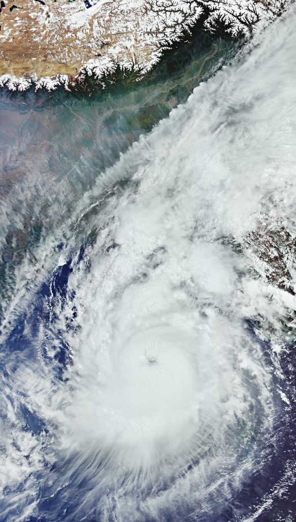
    Cyclone Mocha From Space
    The Copernicus Sentinel-3 satellite captured a comprehensive image of Cyclone Mocha, a record-breaking storm that originated in the Indian Ocean and ravaged the Bay of Bengal in May 2023. With peak winds of 280 km per hour, it ranks among the strongest storms ever in the North Indian Ocean. Despite weakening slightly before reaching Bangladesh and Myanmar, it still caused widespread damage upon landfall, leading to the loss of homes, infrastructural damage, and inundated croplands. Credit: Contains modified Copernicus Sentinel data (2023), processed by ESA

    Cyclone Mocha, a powerful storm, wreaked havoc across the Bay of Bengal in May 2023. The Copernicus Sentinel-3 mission provided vital satellite imagery, aiding disaster response and revealing large-scale global dynamics, including the eastern part of the Himalayas and the Tibetan Plateau.

    The Copernicus Sentinel-3 mission captured this image of the powerful Cyclone Mocha on May 13, 2023, as it made its way across the Bay of Bengal heading northeast towards Bangladesh and Myanmar.

    Cyclone Mocha originated in the Indian Ocean, and it gradually intensified while moving toward the Bay of Bengal. Winds topped 280 km per hour (175 miles per hour), making it one the strongest storms on record in the North Indian Ocean, similar to Cyclone Fani, which hit the same area in May 2019.

    Although the storm weakened slightly as it approached Myanmar and Bangladesh, it caused widespread destruction as it made landfall on May 14.

    With thousands of people losing their houses, infrastructure seriously damaged and croplands inundated, both the International Charter Space and Major Disasters and the Copernicus Emergency Mapping Service were triggered to supply maps based on satellite data to help civil protection authorities and the international humanitarian community with their emergency response efforts.

    Satellites orbiting Earth can provide indispensable up-to-date information to observe such events, as shown here from Copernicus Sentinel-3. The mission is designed to measure, monitor and understand large-scale global dynamics and provides essential information in near-real time for ocean and weather forecasting.

    Acquired with the Ocean and Land Colour Instrument, this wide view covers an area of over 2,000 km (1,200 mi) from north to south. The storm is estimated to be more than 1,000 km (600 miles) across.

    In the cloud-free portion on top of the image, we can see parts of India, Nepal, Bangladesh, and Myanmar, as well as the entire country of Bhutan. The white snow-capped mountains of the eastern part of the Himalayas, including Mount Everest, the highest mountain on the planet, are clearly visible. The Tibetan Plateau – part of China – appears in brownish colors owing to the absence of vegetation.

    Never miss a breakthrough: Join the SciTechDaily newsletter.

    Cyclone European Space Agency Geography Storms Weather
    Share. Facebook Twitter Pinterest LinkedIn Email Reddit

    Related Articles

    This Cyclone Broke Every Rule – And Now It’s Wreaking Havoc

    Before and After: Mayotte’s Shocking Makeover by Cyclone Chido

    Dubai’s Desert Deluge: Satellite Snaps Unusual Flooding Fiasco

    Flash Floods From Ida Swamp the Northeast – Areas Hit With 6-10″ of Rain Fall in Just a Few Hours

    Mediterranean Continues To Bake – Surface Temperatures Over 120° in Turkey and Cyprus

    Smoke Billows From Deadly Wildfires in Turkey

    Monitoring the Devastating US-Canada Heatwave From Space

    Spain’s chilly blanket – Spain Heavy Snowfall Satellite Image

    Madrid Snowbound – Stunning Satellite Image Captures Heaviest Snowfall in 50 Years

    Leave A Reply Cancel Reply

    • Facebook
    • Twitter
    • Pinterest
    • YouTube

    Don't Miss a Discovery

    Subscribe for the Latest in Science & Tech!

    Trending News

    Restricted Blood Flow Supercharges Cancer Growth, Study Finds

    First Ever Dinosaur-Era Dragonfly Fossil Discovered in Canada

    New Fossils Reveal Humans’ Mysterious Lost Cousin

    These 3 Simple Lifestyle Changes Can Cut Diabetes Risk by 31%

    These Simple Everyday Treatments Offer Drug-Free Relief for Knee Arthritis

    30-Year-Old Climate Predictions Were Shockingly Accurate, Study Finds

    Could Glucose Be the Key to Next-Generation Cancer Treatments?

    The Sun’s Hidden Threads Revealed in Stunning Solar Flare Images

    Follow SciTechDaily
    • Facebook
    • Twitter
    • YouTube
    • Pinterest
    • Newsletter
    • RSS
    SciTech News
    • Biology News
    • Chemistry News
    • Earth News
    • Health News
    • Physics News
    • Science News
    • Space News
    • Technology News
    Recent Posts
    • Cornell Scientists Unlock the Secret to Age-Defying Weight Control
    • Rewriting Chemical Rules: Researchers Accidentally Create Unprecedented New Gold Compound
    • The Bright Yellow Worm That Survives by Turning Poison Into “Gold”
    • “A Bad Day at Sea”: Researchers Reveal How Rogue Waves Really Form
    • Scientists Have Uncovered When Jupiter Was Born, Solving a Longstanding Mystery
    Copyright © 1998 - 2025 SciTechDaily. All Rights Reserved.
    • Science News
    • About
    • Contact
    • Editorial Board
    • Privacy Policy
    • Terms of Use

    Type above and press Enter to search. Press Esc to cancel.