
Scientists used satellite and seismic data to prove mega tsunamis in Greenland fjords created trapped standing waves that shook the Earth.
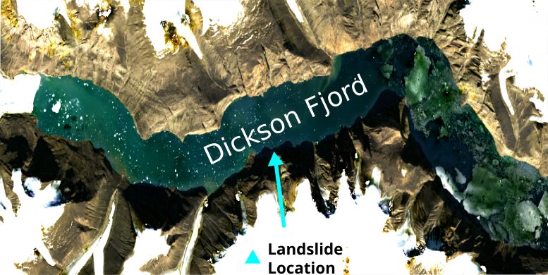
In September 2023, scientists detected a strange global seismic signal that repeated every 90 seconds for nine days and then occurred again a month later. Nearly a year later, two scientific studies suggested that the signal was caused by two massive tsunamis in a remote fjord in East Greenland.
These tsunamis were triggered by major landslides linked to the warming of an unnamed glacier. The resulting waves are believed to have become trapped in the fjord, forming standing waves, or seiches, that moved back and forth and produced the unusual seismic activity.
Until now, there had been no direct observations of these seiches to confirm the theory. Even a Danish military vessel that entered the fjord three days after the first seismic event failed to detect the waves responsible for shaking the planet.
Satellite altimetry sheds new light
In the new study, researchers from Oxford used innovative analysis methods to examine satellite altimetry data. This type of data measures the height of the Earth’s surface, including oceans, by recording how long it takes for a radar pulse to travel from a satellite to the surface and back.
Until now, traditional satellite altimeters could not detect the wave because of long gaps between measurements and because they only collect data directly beneath the satellite, producing one-dimensional profiles along the sea surface. These limitations made it difficult to observe the height differences needed to identify the waves.
For this research, the team used data from the new Surface Water Ocean Topography (SWOT) satellite, which launched in December 2022 to map water height across 90% of the Earth’s surface. The SWOT satellite is equipped with the advanced Ka-band Radar Interferometer (KaRIn), which uses two antennas mounted on a 10-meter boom positioned on either side of the satellite.
These antennas work together to triangulate the return signals from the radar pulse, allowing them to measure ocean and surface water levels with exceptional precision—up to 2.5 meters in resolution—across a 30-mile (50-kilometer) wide swath.
Clear evidence of standing waves
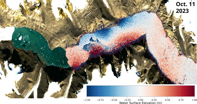
Using KaRIn data, the researchers made elevation maps of the Greenland Fjord at various time points following the two tsunamis. These showed clear, cross-channel slopes with height differences of up to two meters. Crucially, the slopes in these maps occurred in opposite directions, showing that water moved backwards and forwards across the channel.
To prove their theory, the researchers linked these observations to small movements of the Earth’s crust measured thousands of kilometers away. This connection enabled them to reconstruct the characteristics of the wave, even for periods that the satellite did not observe. The researchers also reconstructed weather and tidal conditions to confirm that the observations could not have been caused by winds or tides.
Climate extremes unveiled
Lead author Thomas Monahan (DPhil student, Department of Engineering Science, University of Oxford) said: “Climate change is giving rise to new, unseen extremes. These extremes are changing the fastest in remote areas, such as the Arctic, where our ability to measure them using physical sensors is limited. This study shows how we can leverage the next generation of satellite earth observation technologies to study these processes.”
“SWOT is a game changer for studying oceanic processes in regions such as fjords which previous satellites struggled to see into.”
Co-author Professor Thomas Adcock (Department of Engineering Science, University of Oxford) said: “This study is an example of how the next generation of satellite data can resolve phenomena that has remained a mystery in the past. We will be able to get new insights into ocean extremes such as tsunamis, storm surges, and freak waves. However, to get the most out of these data, we will need to innovate and use both machine learning and our knowledge of ocean physics to interpret our new results.”
Reference: “Observations of the seiche that shook the world” by Thomas Monahan, Tianning Tang, Stephen Roberts and Thomas A. A. Adcock, 3 June 2025, Nature Communications.
DOI: 10.1038/s41467-025-59851-7
Never miss a breakthrough: Join the SciTechDaily newsletter.
Follow us on Google and Google News.
5 Comments
Well if we would stop digging in Antarctica we wouldn’t half to worry so much about weather change digging is making ice melt leave the earth alone dammit
I agree with leve the earth alone 😔
Hahahahahahaha OMG you really believe that digging few holes has ANY effect??? Science is not your playgroud, try mixing drinks for example.
Right on!Leave the Earth alone!
Oh my what? It is pollution messing with ice. Drilling little holes does nothing. Use that noggin and stop guessing.