
Introduction to New Research on First Peoples’ Migration
New research conducted by the University of Sydney sheds light on the migration patterns of the First Peoples of Australia and New Guinea, as well as their habitats over the 40,000 years following humanity’s arrival on the then-unified continent of Sahul. This continent included present-day Australia, Tasmania, and New Guinea. Researchers used a dynamic model to chart the changing landscape, offering a more accurate depiction of the areas inhabited by the earliest humans in Sahul.
Innovative Research Methods
The research team, led by Associate Professor Tristan Salles from the School of Geosciences at the University of Sydney, used a model that factored in the evolution of the landscape, which was influenced by climatic changes during the period of human migration. This novel method enhances traditional migration studies that primarily relied on archaeological discoveries. Salles highlighted the importance of considering geological changes, stating, “One aspect overlooked when evaluating how people spread across the continent is the evolution of the Earth’s surface which took place as people migrated.”
Insights From Landscape Evolution Models
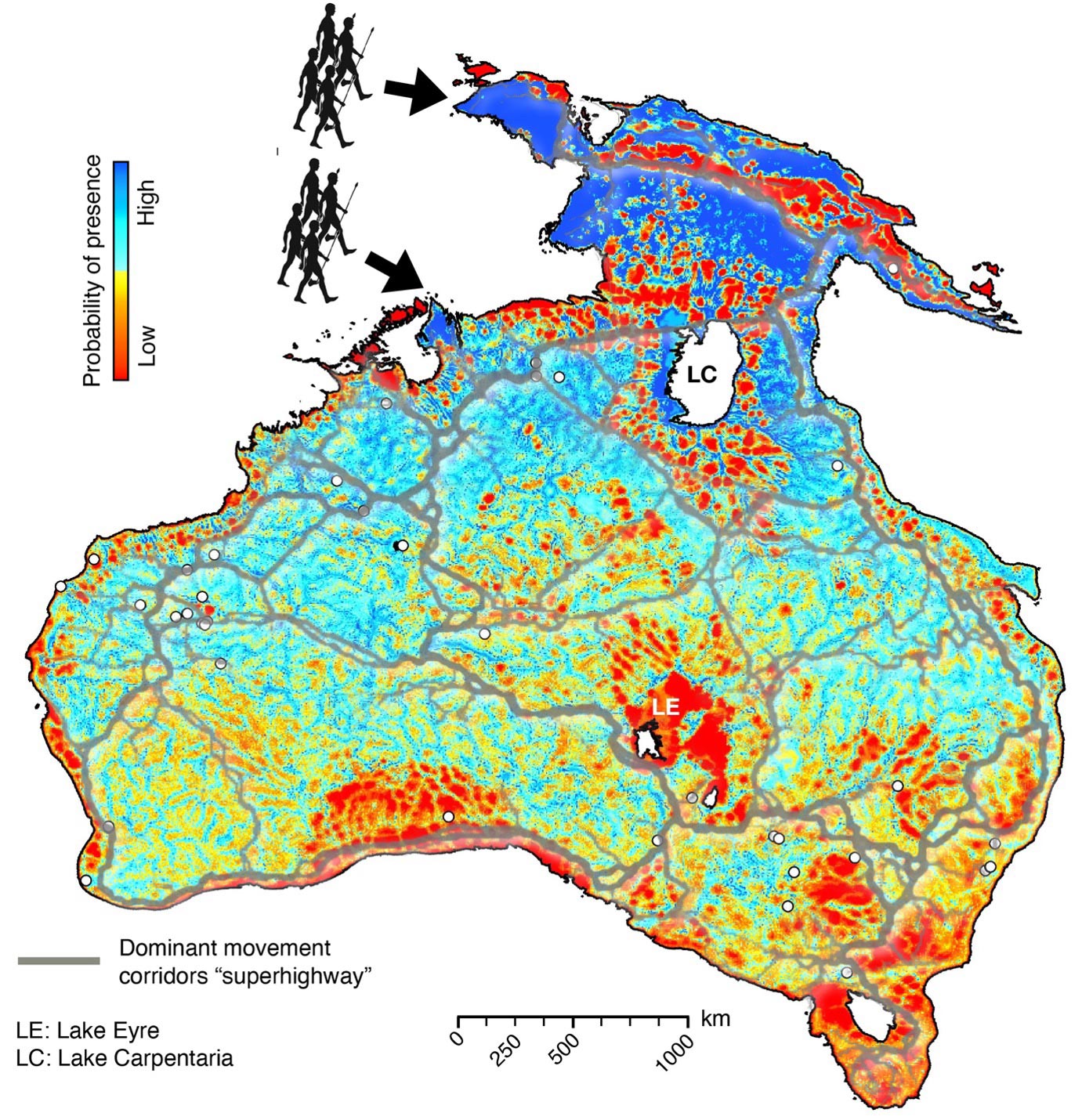
The researchers utilized an existing landscape evolution model that detailed the climatic changes from 75,000 to 35,000 years ago. This model provided new insights into the terrains and environments that the first hunter-gatherer communities encountered as they moved across Sahul. They conducted thousands of simulations to outline potential migration routes from two primary entry points into Sahul: a northern route through Western Papua and a southern route from the Timor Sea shelf.
Correlation Between Archaeological Sites and Migration Patterns
Their findings supported existing archaeological evidence, highlighting high probabilities of human occupation at significant sites like Ngarrabullgan Cave, Puritjarra rock shelter, Riwi Cave, and Carpenter’s Gap 1 rock shelter. The study estimated migration speeds between 360 meters and 1.15 kilometers per year, varying by entry points and times of arrival. It also indicated that human settlers would have spread across the continent’s interior using river corridors around Lake Carpenteria.

Ecological Diversity and Migration Corridors
The research also revealed diverse interior habitats ranging from high-altitude tropical forests and subtropical savannahs to semiarid woodlands and grasslands. Interestingly, the study suggests a radiating wave of migration along rivers and coastlines, aligning with known migration corridors. These findings, combined with mechanistic simulations, could help identify new areas of archaeological interest, potentially guiding future surveys and reducing their associated costs.
Reference: “Physiography, foraging mobility, and the first peopling of Sahul” by Tristan Salles, Renaud Joannes-Boyau, Ian Moffat, Laurent Husson and Manon Lorcery, 23 April 2024, Nature Communications.
DOI: 10.1038/s41467-024-47662-1
Never miss a breakthrough: Join the SciTechDaily newsletter.
Follow us on Google and Google News.