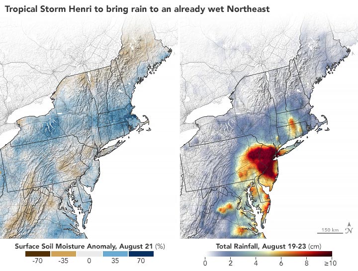
Intense rain fell on Northeast U.S. soils that were already saturated.
Henri did not reach the northeast U.S. coast at hurricane force, but the slow-moving storm still left a soggy mark on the region as it became a rare tropical cyclone to make landfall in New England. Months of rain fell in a few hours across New Jersey, New York, and several other states from August 21-23, landing on soils that were already soaked by an excessively wet summer.
Tropical Storm Henri made landfall near Westerly, Rhode Island, on August 22, 2021, with sustained winds of 60 miles (95 kilometers) per hour and gusts to 70 mph (110 kph). In anticipation of the storm, the cities of Providence, Rhode Island, and New Bedford, Massachusetts, raised storm surge barriers in their ports for the first time since Hurricane Sandy in 2012. But the storm surge never became as severe as feared.
Rainfall was a different story. Widespread accumulations of 4 to 9 inches (10 to 23 centimeters) were recorded in New York, New Jersey, Pennsylvania, and Connecticut. Much of that rainfall fell to the western side of the storm, whereas the eastern and northern sides saw more moderate rainfall.

A broad satellite estimate of rain distribution is captured in the map above, which shows data from August 19–23, 2021. The data are remotely sensed estimates that come from the Integrated Multi-Satellite Retrievals for GPM (IMERG), a product of the Global Precipitation Measurement (GPM) satellite mission. Local rainfall amounts can be significantly higher when measured from the ground.
The other map (below) describes how wet the soil was before Henri even arrived. Using data from the Crop Condition and Soil Moisture Analytics (Crop-CASMA) product, the map shows soil moisture anomalies on August 21, 2021, or how the water content in the top meter (3 feet) of soil compared to normal conditions for the time of year. Crop-CASMA integrates measurements from NASA’s Soil Moisture Active Passive (SMAP) satellite and vegetation indices from the Moderate Resolution Imaging Spectroradiometer (MODIS) instruments on NASA’s Terra and Aqua satellites.
Henri meandered across the Atlantic toward New England for several days, and also moved slowly after landfall. Some meteorologists pointed to a blocking ridge of high pressure over the North Atlantic that kept the storm from moving east and northeast as it usually would. While still well offshore, Henri became connected to other weather systems along the East Coast that pulled in moisture from the outer edges of the storm to provoke downpours.
The soaking started half a day before Henri made landfall. Gauges in New York City’s Central Park recorded 1.94 inches (4.9 centimeters) of rainfall between 10 and 11 p.m. on August 21, and a total of 8.19 inches (20.8 centimeters) by the time the storm had passed on August 23. Another 9.95 inches (25.3 centimeters) fell in Brooklyn. In New Jersey, the town of Cranbury was soaked with 8.91 inches, while Oakland caught 9.22 inches (23.4 centimeters). Ardmore, Pennsylvania, recorded 4.25 inches (10.8 centimeters), while New London, Connecticut—just west of the landfall—received 3.71 inches (9.4 centimeters).
“Henri’s slow westward-then-eastward loop across southern New England over a period of more than 24 hours while still classified as a tropical cyclone is extremely unusual if not unprecedented,” wrote meteorologist Bob Henson in a blog post. “Nearly all tropical depressions, tropical storms, or hurricanes in the region move more rapidly north or northeast, hauled toward the Atlantic by strong upper-level winds more typical at that latitude than the exceptionally weak steering currents present on Monday.”
The soaking rain from Henri fell on a region that was already enduring one of its top three wettest summers on record. According to the National Weather Service, more than 23 inches (58.4 centimeters) of rain have fallen on New York City since June 1. A typical June through August period brings 12 inches.
NASA Earth Observatory images by Joshua Stevens, using soil moisture data from Crop Condition and Soil Moisture Analytics (Crop-CASMA) and IMERG data from the Global Precipitation Mission (GPM) at NASA/GSFC.
Never miss a breakthrough: Join the SciTechDaily newsletter.
Follow us on Google and Google News.