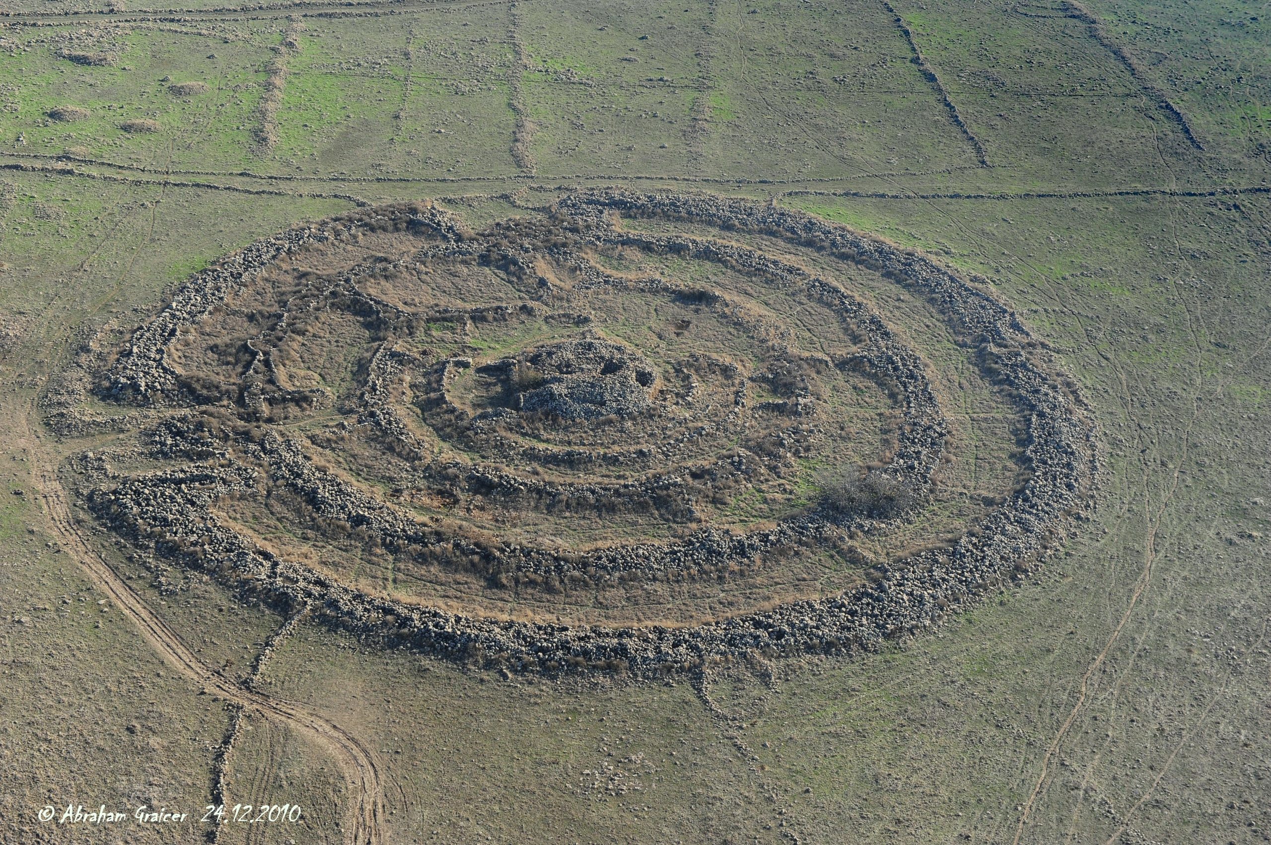
A scientific discovery challenges the common perception of Rujm el-Hiri in the Golan Heights.
A new study by Tel Aviv University and Ben-Gurion University of the Negev has unveiled groundbreaking insights into the Rujm el-Hiri site, also known as the “Wheel of Ghosts,” located in the Golan Heights. Using geomagnetic analysis and tectonic reconstruction, researchers have determined that geodynamic movements over the past 150 million years, occurring at an average rate of 8–15 mm per year, caused significant shifts in the ground. These movements gradually rotated and reoriented the site’s structure over millennia.
This discovery casts doubt on the prevailing theory that the structure served as an astronomical observatory. The researchers found that the original alignment of the site’s walls and entrances does not align with celestial patterns, contradicting earlier hypotheses about its purpose.
The study was conducted by a research team led by Dr. Olga Khabarova and Prof. Lev Eppelbaum of the Department of Geophysics at Tel Aviv University’s Porter School of the Environment and Earth Sciences, in collaboration with Dr. Michal Birkenfeld of Ben-Gurion University’s Department of Archaeology. The findings were published in the journal Remote Sensing.
The researchers employed geophysical methods and remote sensing techniques to demonstrate that Rujm el-Hiri’s current orientation differs from its original position due to thousands of years of geodynamic shifts. This discovery raises new questions regarding the site’s possible identification as an observatory. The team conducted initial mapping and documentation of the archaeological landscape within 30 kilometers around the Sea of Galilee. It visually analyzed the region to identify typical landscape features associated with historical human activity and the reconstruction of archaeological objects.
Reassessment of Rujm el-Hiri’s Alignment
According to the research team, “The study was based on calculations of the sky map and aligning the directions of the solstices, equinoxes, and other celestial bodies as they appeared between 2500–3500 BCE, coordinated with the symmetry and entrances of Rujm el-Hiri in its current position. The findings show that the entrances and radial walls during that historical period were entirely different, reopening the question of the site’s purpose.”
The research team explains: “Due to geodynamic movement lasting approximately 150 million years, at an average speed of 8–15 mm per year, the ground in the area has undergone significant shifts. The orientation of the walls and entrances in their original positions does not align with celestial observations, as previously believed.”

The researchers conclude: “This new study not only opens a window to understanding Rujm el-Hiri but also enriches our knowledge of ancient life in the Golan Heights and the connections between various archaeological findings in the area.”
Reference: “Discussion Points of the Remote Sensing Study and Integrated Analysis of the Archaeological Landscape of Rujm el-Hiri” by Olga Khabarova, Michal Birkenfeld and Lev V. Eppelbaum, 13 November 2024, Remote Sensing.
DOI: 10.3390/rs16224239
Never miss a breakthrough: Join the SciTechDaily newsletter.
Follow us on Google and Google News.
2 Comments
How about returning the land to the Syrians?
How about removing all of em and allowing the Jewish settlements\ settlers to inhabit the whole area,much better for security 🤔🤞🙏🤣