High above the vast Sahara Desert, an astronaut captured a breathtaking image of Emi Koussi—a massive, shadow-casting volcano with salt flats, lava flows, and mysterious dry stream channels carved by ancient water.
It stands as the highest point in the Sahara, revealing secrets of both fire and water etched into its rugged landscape.
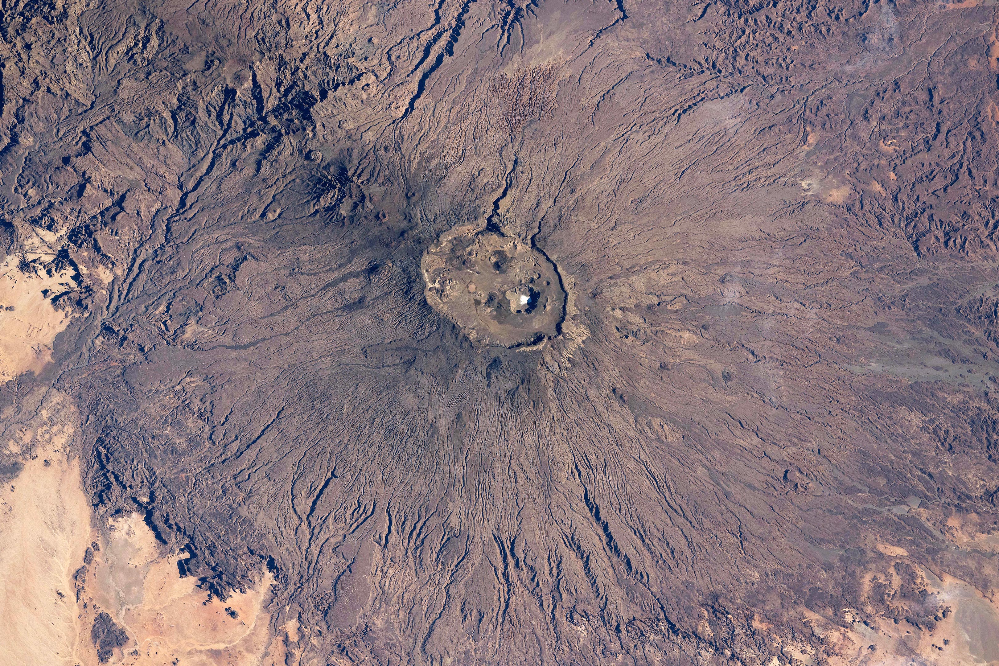
Towering Volcano in the Sahara
An astronaut aboard the International Space Station (ISS) recently captured this stunning photo of Emi Koussi, a massive volcano rising from the heart of the Sahara Desert in northern Chad. Spanning an incredible 70 kilometers (43 miles) across, the volcano’s wide cone is streaked with dark lava flows that hint at its fiery past.
At the center of the image lies the summit of Emi Koussi, perched on the rim of a dramatic elliptical caldera that casts deep, dark shadows across the terrain. Towering at 3,415 meters (11,204 feet), it’s the highest point in the entire Sahara, surrounded by sunlit flats of pale desert sand.
Salt Lake and Volcanic Vents
Look closer, and you’ll spot something unexpected: a bright white salt-covered lakebed nestled at the bottom of the caldera — a striking contrast against the dark volcanic rock. This dry salt lake sits about 745 meters (2,450 feet) below the summit. Nearby, you can also spot several circular volcanic vents, remnants of ancient eruptions, adding even more drama to this otherworldly landscape.
Numerous dry stream channels appear as thin lines on the flanks of the volcano, radiating away from the caldera. Despite very low rainfall in the region, geologists think that such channels were formed by water-driven erosion that occurred over thousands of years. Several channels on the lower slopes, including those toward the bottom of the image, are marked by shadows.
Hidden Canyons and Volcanic Neighbors
A line of small, circular cones and vents appears on the volcano’s north flank. The line runs toward the slopes of Tarso Ahon, another large volcanic mountain. A depression between Emi Koussi and Tarso Ahon is occupied by deep canyons that cast the largest shadows. One canyon is 600 meters (2,000 feet) deep and leads water west, while the other is 250 meters (700 feet) deep and leads water east. The canyons formed in the depression due to the concentration of water runoff from both Emi Koussi and Tarso Ahon.
This photo, labeled ISS072-E-423041, was taken by an astronaut aboard the International Space Station on December 29, 2024, using a Nikon Z9 digital camera with a 200mm lens. It was captured during Expedition 72 and comes from the ISS Crew Earth Observations Facility and the Earth Science and Remote Sensing Unit at NASA’s Johnson Space Center.
To enhance visibility, the image has been cropped and adjusted for contrast, and lens artifacts were removed. The International Space Station Program supports this photography effort as part of the ISS National Lab, helping astronauts document Earth in ways that are valuable to both scientists and the public. These images are freely available online
Never miss a breakthrough: Join the SciTechDaily newsletter.
Follow us on Google and Google News.
3 Comments
thank you
What are the dates of the eruptions are they in a line with each other or skaters?
https://en.m.wikipedia.org/wiki/Emi_Koussi#:~:text=Emi%20Koussi%20erupted%20between%202.4,the%20oldest%20Emi%20Koussi%20stage.