Millions of people around the world face hunger every day, and unfortunately, the COVID-19 pandemic is expected to make the issue of food security even worse. Satellites are helping to alleviate the situation by providing crucial information to monitor crop growth and harvesting from space.
A recent report from the World Food Programme forecasts that the COVID-19 pandemic could push over 130 million additional people into chronic hunger by the end of 2020. The pandemic has caused numerous problems and uncertainties along the food supply chain such as limited labor, transport, cross-border trade, and the availability of produce.
It is important to understand how the pandemic is disrupting the growth and harvest of staple crops as well as the food supply chain, which can be affected by various factors such as shortages of fertilizer, a lack of labor, and issues associated with national export policies. These limitations create uncertainty in food markets and, therefore, the availability of food in the future.
Satellite monitoring tools are useful as they can provide information on planting and harvesting for key food and agriculture commodities.
NASA, ESA, and the Japanese Aerospace Exploration Agency (JAXA) worked recently to create the COVID-19 Earth Observation Dashboard, a platform that combines a wealth of satellite data to monitor the impacts of COVID-19 worldwide – including agricultural production.
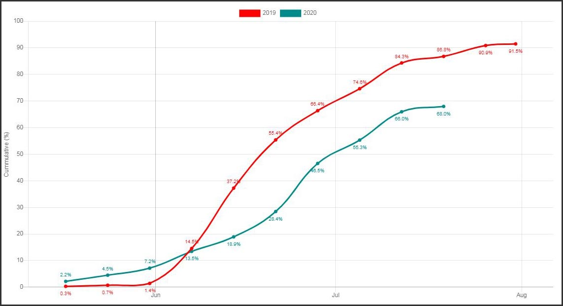
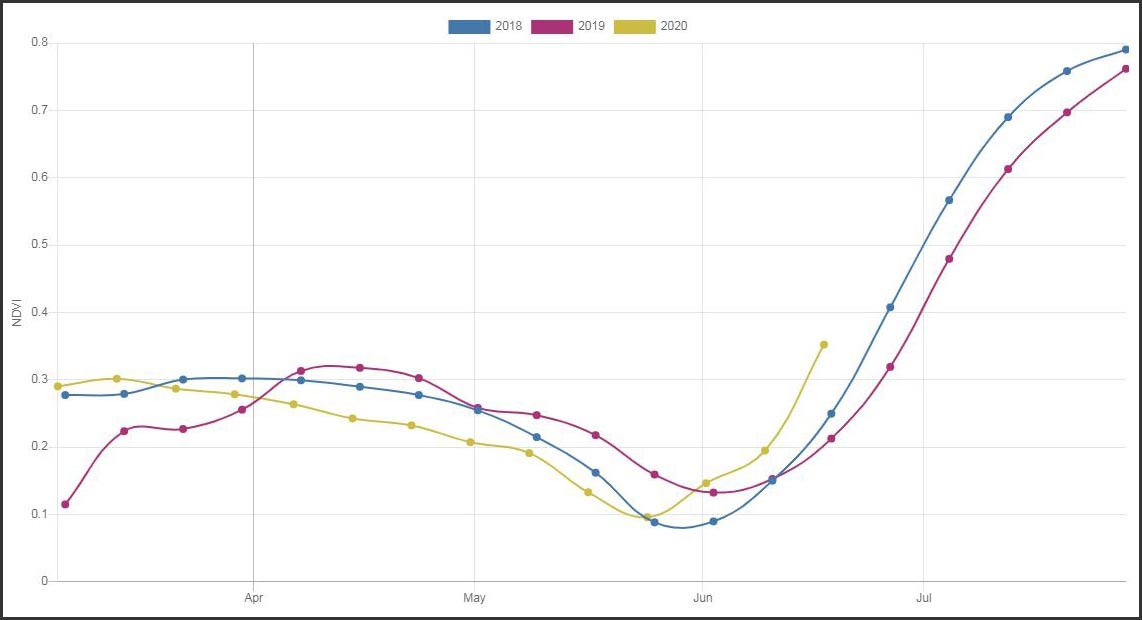
A recent study, featured on the dashboard, analyzed the harvests of winter cereals in Spain. In Spain, winter cereals are cultivated over almost two million hectares, mainly in the regions of Castilla and León, Andalucia, Castilla-la-Mancha, and Aragón. Thanks to satellite data, the harvests can be monitored in near-real time, at parcel level over the entire country.
Scientists from the Université catholique de Louvain in Belgium used data from the Copernicus Sentinel-1 and Sentinel-2 missions and the US Landsat-8 mission together with machine learning to monitor crops on a weekly basis. Comparing the data with that of last year, they found that the 2020 harvesting season started in mid-June, which is later than the average crop calendar for winter cereals in Spain.
Experts from the National Spanish Agrarian Guarantee Fund (FEGA) supported the monitoring and worked with Université catholique de Louvain (UCL) to analyze the results – and while COVID-19 may have contributed to the delayed harvest, the weather may have also played a role.
Sophie Bontemps, scientist at UCL, said, “After consulting our colleagues at FEGA, the time lag in harvesting can be explained partially by the drought that affected Europe in 2019, which led to an unusually early harvest last year. Therefore, the assessment of COVID-19 impacts on the 2020 harvest must consider the interannual variability caused by specific climate conditions in 2019.”
National Paying Agencies such as FEGA for Spain are responsible for the implementation of the European Common Agricultural Policy, which requires crops to be monitored nationally. In collaboration with the European Commission, ESA has developed the Sen4CAP processing system, which was used here for the national-scale harvest monitoring.
In another example featured on the dashboard, data from JAXA’s ALOS-2 and GCOM-C satellites, combined with information from the Landsat and Copernicus Sentinel-2 missions, were used to assess rice fields near Sacramento, California, US. These satellites can provide key information on rice phenology such as when rice is planted, when it matures, and when it is harvested.
JAXA/NASA/USGS/ESA
Here, satellite observations show that in many regions, the rice was planted earlier than in the last two years. These early assessments allow agriculture markets to respond more efficiently to disruptions owing to natural events such as the weather and to human-caused events such as changes in trade policy and consumer demand triggered, for example, by the COVID-19 pandemic.
ESA’s Benjamin Koetz, comments, “Satellite indicators demonstrate the capabilities of monitoring the planting, growth, and harvest of staple crops such as cereals and rice at national scales. These data are vital in providing timely and transparent information on agricultural production during the COVID-19 outbreak and recovery.
“ESA, NASA, and JAXA continue to work with organizations such as the UN Food and Agriculture Organization and the Group on Earth Observations Global Agricultural Monitoring Initiative to ensure the best use of satellites to monitor agricultural production from national to global scales.”
Never miss a breakthrough: Join the SciTechDaily newsletter.
Follow us on Google and Google News.