Merging data from multiple satellites, OPERA can help government agencies, disaster responders, and the public access data about natural and human impacts to the land.
The OPERA (Observational Products for End-Users from Remote Sensing Analysis) project, managed by NASA’s Jet Propulsion Laboratory, aims to provide users with free and timely access to satellite-based observations of Earth’s dynamic surface water and land. By leveraging cloud computing, OPERA turns massive amounts of satellite data into analysis-ready products for federal agencies, facilitating more informed decision-making. The first round of OPERA products will be available in April 2023, combining data from various satellites, such as the ESA Sentinel-2 A/B, Landsat 8, and the recently launched Surface Water and Ocean Topography satellite. OPERA’s product suite includes comprehensive monitoring of lakes, rivers, reservoirs, and streams, as well as mapping changes in vegetation cover and measuring North American surface displacement.
Where are flood waters flowing after major storms? Where are the changes in tree and plant cover after droughts, wildfires, deforestation, or mining? How much did the land move during an earthquake or volcanic eruption? Scientists routinely rely on data-intensive analysis and visualization of satellite observations to track Earth’s ever-changing surface. A new project will make it possible for anyone with an internet connection to begin to answer these questions and more about changes to our dynamic planet.
The OPERA (Observational Products for End-Users from Remote Sensing Analysis) project is managed by NASA’s Jet Propulsion Laboratory, with partners from NASA’s Goddard Space Flight Center, the U.S. Geological Survey (USGS), the University of Maryland, the University of Alaska Fairbanks, and Southern Methodist University. Scientists conceived OPERA in 2020 to address satellite data needs across different federal agencies and to enable better access to information on everything from water management to wildfire monitoring. The goal is to make specific satellite-based observations free and timely for users. The first offerings will be available in April 2023, with more to follow.

“Quite often satellite missions are driven by science, applications, or technology demonstration. In OPERA, we focus on fulfilling the operational needs identified by federal agencies who rely on our work,” said David Bekaert, OPERA project manager based at JPL. “We leverage cloud computing to turn massive amounts of satellite observations into analysis-ready products relevant to our federal stakeholders. Shortening the path from satellite observation to stakeholder decision is a key driver behind the overall implementation and execution of OPERA.”
OPERA is aggregating a unique combination of user-friendly data about Earth’s dynamic surface water and land, noted John Jones, a USGS scientist and OPERA project partner.
“The magic of OPERA is that it transcends any one space mission,” said Gerald Bawden, program scientist at NASA Headquarters in Washington, who helped envision the project as part of the interagency Satellite Needs Working Group. Created by the Office of Management and Budget and the U.S. Group on Earth Observations, the Satellite Needs Working Group seeks to identify the satellite needs of U.S. federal agencies and develop new remote sensing products that fulfill their observational gaps.
The first round of OPERA products ties together visible and infrared measurements from the ESA (European Space Agency) Sentinel-2 A/B satellites and from Landsat 8, built by NASA and operated by the USGS. These instruments will soon be augmented by data from the cloud-penetrating radars on ESA’s Sentinel-1 A/B satellites and the recently launched Surface Water and Ocean Topography (SWOT) satellite, a partnership between NASA and the French space agency CNES (Centre National d’Études Spatiales). OPERA will eventually ingest satellite radar data from the NASA-Indian Space Research Organisation Synthetic Aperture Radar (NISAR) satellite, planned for launch in 2024.
Mapping Surface Water
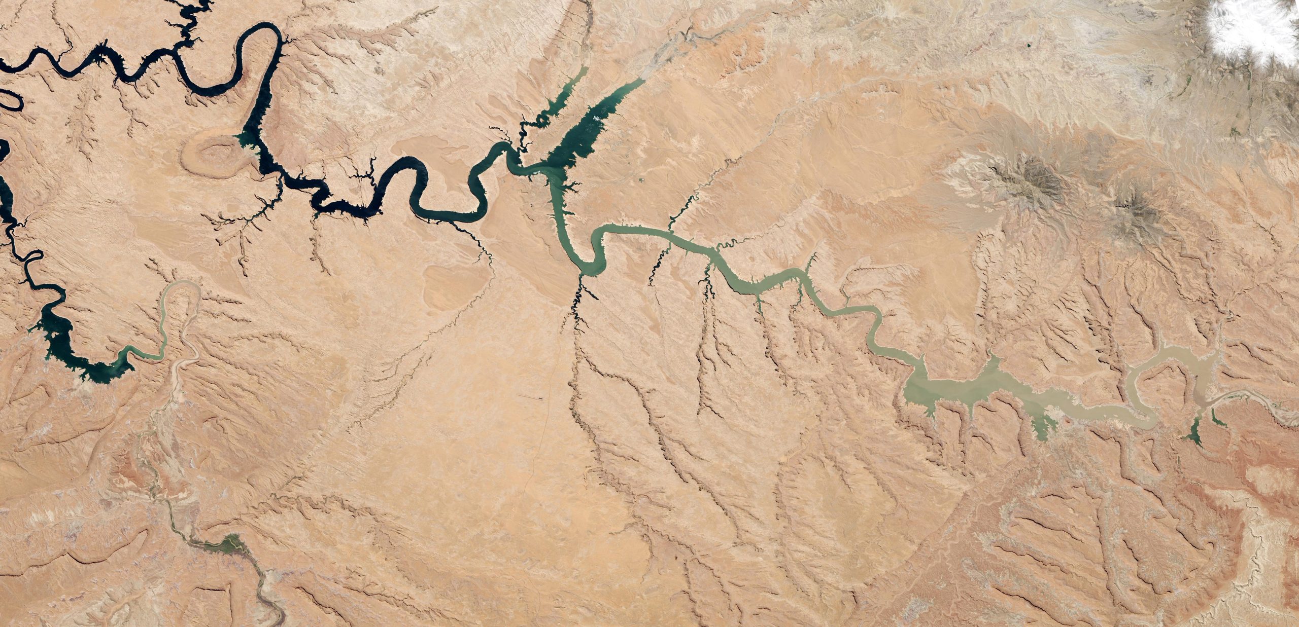
OPERA’s Dynamic Surface Water eXtent product suite offers what may be the most comprehensive data source for monitoring lakes, rivers, reservoirs, and streams. The first phase relies on Harmonized Landsat Sentinel-2 (HLS) optical data to generate near-global surface water mapping every few days at a 30-meter spatial resolution. Subsequent phases will use Sentinel-1, SWOT, and NISAR radar observations to map surface water more often (because radar can penetrate cloud cover).
For example, when a series of nine atmospheric river events brought heavy rain and snow to California in the winter of 2022-23, several flood-control dams faced risks of overflowing. OPERA’s surface water maps chronicled the dramatic filling of these reservoirs.
Monitoring Surface Disturbance
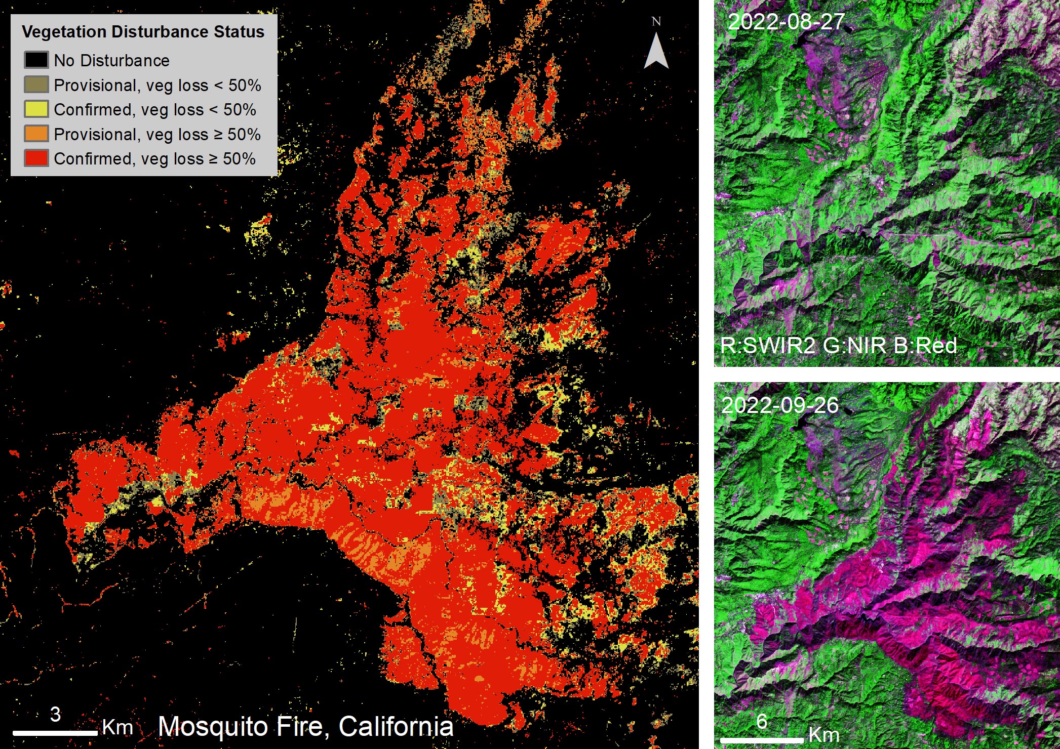
OPERA’s products offer new insights into both environmental and geological processes taking place on Earth’s land surfaces. Complementing its water product suite, OPERA’s Surface Disturbance product uses HLS data to map changes in vegetation cover. It could be used to observe the scars and regrowth after wildfires, track growing cities, or even discover insect infestations in forests.
“We are very excited to employ integrated Landsat and Sentinel-2 data,” said Matt Hansen, a professor at the University of Maryland and OPERA project partner. “The combined observations provide an unprecedented capability and, we expect, an unprecedented record of global land change.”
For example, the Mosquito Fire was detected on September 6, 2022, and burned predominantly in the Tahoe and Eldorado National Forests. OPERA’s surface disturbance data product shows vegetation losses due to the fire – California’s largest of the year – which covered some 76,788 acres and lasted for 50 days.
Measuring North America Surface Displacement
OPERA’s third product, slated for release in late 2024, will provide a history of how much land surfaces in North America have moved, or deformed, due to geologic and human activities. The surface displacement product will map surface motion that is otherwise imperceptible without a vast network of GPS instruments.
“This is a transformative product for detecting landslides, sinkholes, earthquakes, volcanoes – anything that is changing the land surface,” said Bawden. “Using these satellites, we’re able to measure motions on the ground surface less than an inch. And we can begin to explore how those motions are impacting everything living there.”
All OPERA products are publicly accessible. The surface water and surface disturbance products are currently available through NASA Distributed Active Archive Centers, Physical Oceanography Distributed Active Archive Center, and Land Processes Distributed Active Archive Center, respectively.
Never miss a breakthrough: Join the SciTechDaily newsletter.
Follow us on Google and Google News.