Close Menu
    Facebook X (Twitter) Instagram
    SciTechDaily
    • Biology
    • Chemistry
    • Earth
    • Health
    • Physics
    • Science
    • Space
    • Technology
    Facebook X (Twitter) Pinterest YouTube RSS
    SciTechDaily
    Home»Earth»Ground Displacement From Puerto Rico Earthquake Mapped by NASA
    Earth

    Ground Displacement From Puerto Rico Earthquake Mapped by NASA

    By NASA's Jet Propulsion LaboratoryJanuary 11, 2020No Comments3 Mins Read
    Facebook Twitter Pinterest Telegram LinkedIn WhatsApp Email Reddit
    Share
    Facebook Twitter LinkedIn Pinterest Telegram Email Reddit
    NASA Maps Ground Changes From Puerto Rico Earthquake
    This map shows ground changes, or displacement, on the eastern two-thirds of Puerto Rico following a 6.4-magnitude earthquake. The ground shifted up to 5.5 inches (14 centimeters) in a downward and slightly west direction. Credit: NASA/JPL-Caltech, ESA, USGS

    Scientists use satellite data to help response agencies identify damaged areas.

    Days after a 6.4-magnitude earthquake rocked Puerto Rico, followed by hundreds of aftershocks, the full extent of damage is only beginning to be realized.

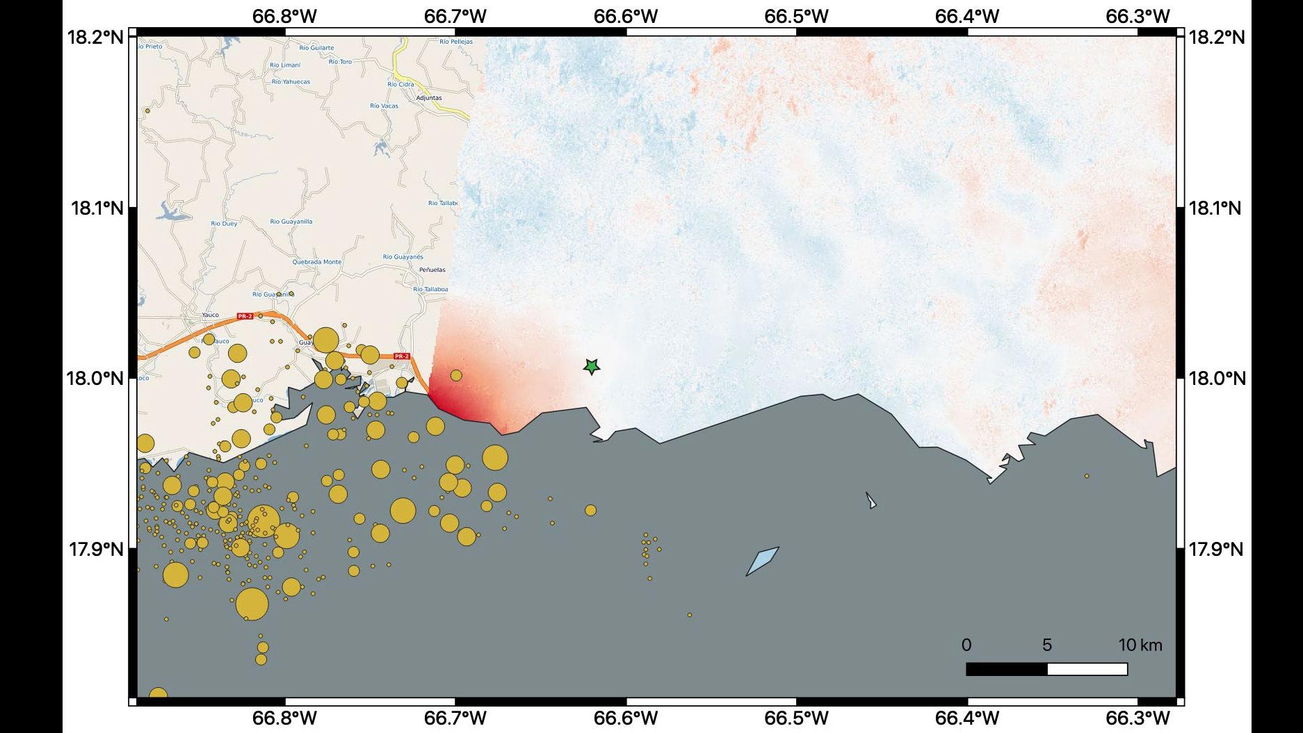
    NASA scientists are using satellite data to help federal and local agencies identify areas with potential damage. Earthquakes cause permanent changes to the ground surface. By comparing interferometric synthetic aperture radar (InSAR) data acquired on January 9, 2020, with data acquired on December 28, 2019, from the Copernicus Sentinel-1A satellite, the scientists were able to map where, how much and in what direction those changes occurred.

    Managed by the European Space Agency (ESA), the Copernicus Sentinel-1A satellite was able to see the eastern two-thirds of the island during the January 9 flyover. On the map, red indicates areas where the ground was changed, or displaced, with darker shades corresponding to more significant displacement. The scientists found that the greatest displacement from the flyover area occurred west of the city of Ponce (identified by the green star), not far from the quake’s offshore epicenter. They recorded up to 5.5 inches (14 centimeters) of ground change there. The ground appeared to shift downward and slightly to the west.

    The quake epicenter and the cluster of quakes and aftershocks in the region identified by the United States Geological Survey (shown as orange circles) fall just west of the satellite’s Jan. 9 track. Because of this, scientists also plan to analyze data from Sentinel-1A’s forthcoming Jan. 14 flyover, which will include western Puerto Rico.

    The NASA Earth Applied Sciences Disasters Program has activated Tier 1 response in support of this disaster and is in contact with the Federal Emergency Management Agency, the United States Geological Survey and Health and Human Services (HHS) to provide NASA Earth-observing data in support of response and recovery efforts. Products in the process of being produced include Suomi-NPP-based “Black Marble” power outage maps, damage maps, and landslide maps. A webpage has also been created on the NASA Disasters Mapping Portal to supply relevant GIS data products.

    The map contains modified Copernicus Sentinel data processed by ESA and analyzed by scientists at NASA’s Jet Propulsion Laboratory, and earthquake location data from the USGS.

    Never miss a breakthrough: Join the SciTechDaily newsletter.
    Follow us on Google and Google News.

    Earthquakes European Space Agency JPL NASA
    Share. Facebook Twitter Pinterest LinkedIn Email Reddit

    Related Articles

    Advanced New Spacecraft Will Monitor Sea Level Rise and Atmospheric Temperature With Extreme Precision

    Search for Extra-Terrestrial Life Takes Mars Scientists on Expedition to Australia

    Searching for Link Between Star Formation and Black Hole Activity

    Increased Methane Gas Levels Found Over Cracks in Arctic Sea Ice

    NASA Makes Earth’s Oceans Look like Van Gogh’s Starry Night

    GRACE Data Spreads Awareness of Groundwater Levels

    New Images of Orion Nebula Show Young Stars Hidden in Gas and Dust Clouds

    Lidar Equipment Provides Comprehensive Pictures Earthquake Zones

    NASA Satellite Image Shows La Niña Peaking in Intensity

    Leave A Reply Cancel Reply

    • Facebook
    • Twitter
    • Pinterest
    • YouTube

    Don't Miss a Discovery

    Subscribe for the Latest in Science & Tech!

    Trending News

    AI Could Detect Early Signs of Alzheimer’s in Under a Minute – Far Before Traditional Tests

    What if Dark Matter Has Two Forms? Bold New Hypothesis Could Explain a Cosmic Mystery

    This Metal Melts in Your Hand – and Scientists Just Discovered Something Strange

    Beef vs. Chicken: Surprising Results From New Prediabetes Study

    Alzheimer’s Breakthrough: Scientists Discover Key Protein May Prevent Toxic Protein Clumps in the Brain

    Quantum Reality Gets Stranger: Physicists Put a Lump of Metal in Two Places at Once

    Scientists May Have Found the Key to Jupiter and Saturn’s Moon Mystery

    Scientists Uncover Brain Changes That Link Pain to Depression

    Follow SciTechDaily
    • Facebook
    • Twitter
    • YouTube
    • Pinterest
    • Newsletter
    • RSS
    SciTech News
    • Biology News
    • Chemistry News
    • Earth News
    • Health News
    • Physics News
    • Science News
    • Space News
    • Technology News
    Recent Posts
    • What if Your Memories Never Happened? Physicists Take a New Look at the Boltzmann Brain Paradox
    • Students Found an Ancient Star That Shouldn’t Be in the Milky Way
    • Astronomers Solve 50-Year Mystery and Reveal Hidden Culprit Behind Strange X-Ray Emissions
    • One of the Universe’s Largest Stars May Be Getting Ready To Explode
    • Scientists Discover Enzyme That Could Supercharge Ozempic-Like Weight Loss Drugs
    Copyright © 1998 - 2026 SciTechDaily. All Rights Reserved.
    • Science News
    • About
    • Contact
    • Editorial Board
    • Privacy Policy
    • Terms of Use

    Type above and press Enter to search. Press Esc to cancel.