The latest round of eruptions on the Reykjanes peninsula destroyed homes in the town of Grindavík.
Volcanic activity reawakened on the Reykjanes peninsula in southwestern Iceland with a pulse of eruptions in mid-January 2024. Over the course of about two days, new fissures released lava near the town of Grindavík. A human-constructed barrier diverted some of the flow from one fissure away from town, but lava from one closer to Grindavík engulfed several homes. The eruption occurred less than a month after another fissure opened several kilometers to the northeast. It was the fifth eruption on the peninsula since 2021.
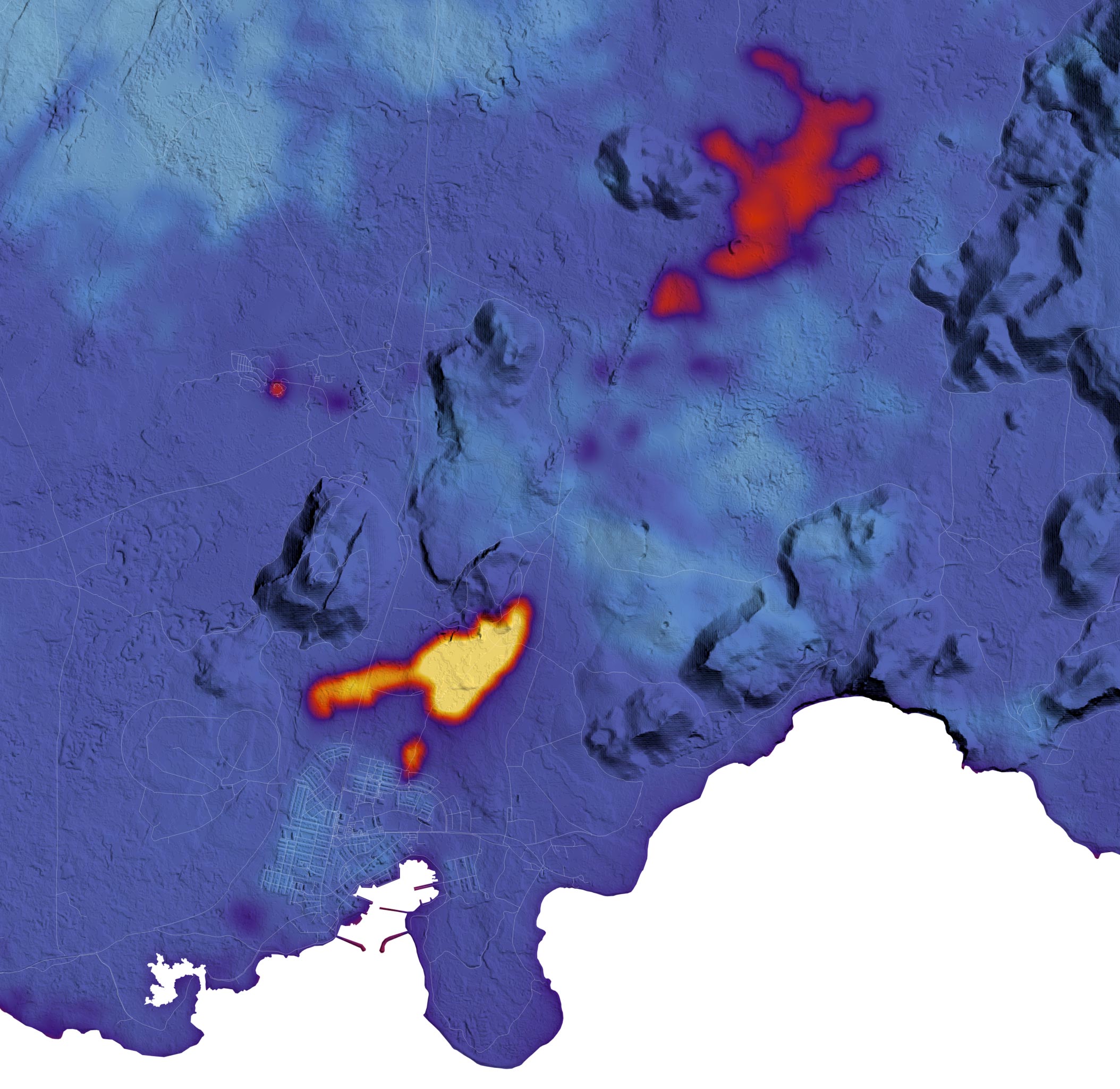
Satellite Data Highlights Eruption Impact
The map above indicates the location and extent of the recent activity. Data for the map were acquired by the TIRS-2 (Thermal Infrared Sensor 2) on the Landsat 9 satellite on January 16, 2024, and overlaid on a digital elevation model of the area. TIRS-2 detects thermal radiation in two wavelengths, revealing the amount of heat emanating from surfaces on Earth. Lava flows from the January 2024 eruption appear the warmest (yellow), while the still-warm December 2023 flows and the Blue Lagoon geothermal pool also stand out from the relatively cooler surrounding land. Scattered clouds (light blue) account for areas with the coolest temperatures.
Timeline and Response to the Eruption
A fissure eruption began at 7:57 a.m. local time on January 14, 2024, approximately 1 kilometer away from Grindavík. It followed several hours of increased seismicity, according to the Icelandic Met Office. Some lava from this fissure flowed toward town, while some was diverted to the west by barriers of earth and rock constructed starting in November 2023 when the risk of imminent hazard became apparent.
At 12:20 p.m. local time, a second, smaller fissure opened outside of the barrier at the edge of town and oozed lava that burned three homes. Drone footage from that day captured both flows, which turned out to be relatively short-lived. By the morning of January 16, the Icelandic Met Office reported that activity was no longer visible and that seismicity had decreased.
Historical Context and Future Hazards
Stopping hot, viscous rock is a difficult feat, and past efforts have been met with mixed results. Famously on Iceland’s Heimaey island 51 years ago, workers sprayed millions of tons of seawater on a lava flow’s edge to cool and slow it, preventing it from destroying a harbor. Most recent efforts have taken the barrier approach like at Grindavík, aiming to redirect lava onto a less destructive path.
More battles with lava may follow on the Reykjanes peninsula, as hazards remain high. Modeling showed that magma has moved beneath Grindavík and deformed the ground by as much as 1.4 meters (4.6 feet). Experts have told news sources that bursts of activity could continue in a cyclical pattern.
NASA Earth Observatory image by Lauren Dauphin, using Landsat data from the U.S. Geological Survey.
Never miss a breakthrough: Join the SciTechDaily newsletter.
Follow us on Google and Google News.