
Close Menu
    Facebook X (Twitter) Instagram
    SciTechDaily
    • Biology
    • Chemistry
    • Earth
    • Health
    • Physics
    • Science
    • Space
    • Technology
    Facebook X (Twitter) Pinterest YouTube RSS
    SciTechDaily
    Home»Earth»NASA Satellite Captures 360-View of Hurricane Maria
    Earth

    NASA Satellite Captures 360-View of Hurricane Maria

    By Ellen Gray, NASA's Earth Science News TeamOctober 5, 2018No Comments2 Mins Read
    Facebook Twitter Pinterest Telegram LinkedIn WhatsApp Email Reddit
    Share
    Facebook Twitter LinkedIn Pinterest Telegram Email Reddit

    Dive Into a 360 View of Hurricane Maria

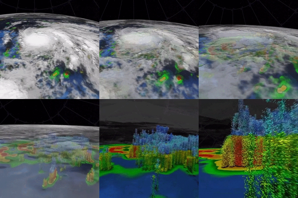
    Two days before Hurricane Maria devastated Puerto Rico, the NASA/JAXA Global Precipitation Measurement Core Observatory satellite captured a 3D view of the 2017 storm. At the time Maria was a category 1 hurricane. The 3-D view reveals the processes inside the hurricane that would fuel the storm’s intensification to a category 5 storm within 24 hours.

    For the first time in 360 degrees, this data visualization takes you inside the hurricane. The precipitation satellite has an advanced radar that measures both liquid and frozen water. The brightly colored dots show areas of rainfall, where green and yellow show low rates and red and purple show high rates. At the top of the hurricane, where temperatures are colder, blue and purple dots show light and heavy frozen precipitation. The colored areas below the dots show how much rain is falling on the surface.


    For the first time in 360 degrees, this data visualization takes you inside Hurricane Maria. Credit: NASA’s Goddard Space Flight Center

    As the visualization progresses, the dots transform into numbers, which are the observed millimeters of precipitation that fall in an hour. The rates in this storm vary from less than 0.5 mm/hr to more than 150 mm/hr. The visualization next transforms these precipitation rates into ellipsoids to show higher (wide, red, or purple) or lower (spherical, green, or yellow) rainfall rates and snowfall rates (purple to blue colors). In addition to rain and snowfall rates, the satellite can also measure the sizes of tiny precipitation particles and how they are distributed throughout the storm. Toward the end of the visualization, big drops are depicted in dark blue, and small drops in light blue and white.

    Looking at drop sizes and rainfall rates provides a key part of the equation in understanding hurricane intensity. Factors such as temperature, humidity, wind speed, and clouds influence the size of precipitation particles, which in turn affects how much rain falls and how a storm grows. These advanced satellite measurements are critical for improving forecasts of how these powerful storms may intensify and where they may go.

    Never miss a breakthrough: Join the SciTechDaily newsletter.
    Follow us on Google and Google News.

    Earth Science Hurricane Weather
    Share. Facebook Twitter Pinterest LinkedIn Email Reddit

    Related Articles

    Evidence That The Southern Amazon Rainforest Triggers Its Own Rainy Season

    NASA Shows Current Sierra Snowpack Bigger Than Last Four Years Combined

    New Research Examines the Intersection of Weather and Climate

    MIT Study Predicts Frequency of Heavy Precipitation with Global Warming

    AIM Spacecraft Observes Early Noctilucent Ice Clouds Over Antarctica

    El Niño Continues to Grow, Set to Bear Down on U.S.

    2015 El Niño Appears Likely to Equal the Event of 1997-98

    “Grey Swan” Cyclones Will Become More Frequent and Intense

    Hurricane Sandy Viewed From Space

    Leave A Reply Cancel Reply

    • Facebook
    • Twitter
    • Pinterest
    • YouTube

    Don't Miss a Discovery

    Subscribe for the Latest in Science & Tech!

    Trending News

    Chimpanzees Keep Throwing Stones at the Same Trees – Scientists Want To Know Why

    Coffee May Protect the Liver in More Ways Than Scientists Realized

    AI Just Uncovered a Hidden Secret Inside Water

    Scientists Catch a “Jumping Gene” Moving Between Species

    This Tiny-Bead Procedure Is Helping Patients Avoid Knee Replacement

    Neanderthals Nearly Vanished 75,000 Years Ago – Then One Group Repopulated Europe

    AI Detects Hidden Warning Signs Before Major Earthquakes

    Scientists Have Found Evidence That Dark Matter May Not Be Playing by the Rules

    Follow SciTechDaily
    • Facebook
    • Twitter
    • YouTube
    • Pinterest
    • Newsletter
    • RSS
    SciTech News
    • Biology News
    • Chemistry News
    • Earth News
    • Health News
    • Physics News
    • Science News
    • Space News
    • Technology News
    Recent Posts
    • 567-Million-Year-Old Fossils Suggest Animals Evolved Earlier Than We Thought
    • Scientists Discover a 5-Million-Year-Old Whale Graveyard Deep Beneath the Indian Ocean
    • Ancient DNA Reveals the Hidden Origins of China’s Mysterious Shimao Civilization
    • Scientists Finally Solve a 50-Year Mystery Hidden in Solid Nitrogen
    • Saturn’s Largest Moon May Hold the Resources for a Space Colony
    Copyright © 1998 - 2026 SciTechDaily. All Rights Reserved.
    • Science News
    • About
    • Contact
    • Editorial Board
    • Privacy Policy
    • Terms of Use

    Type above and press Enter to search. Press Esc to cancel.