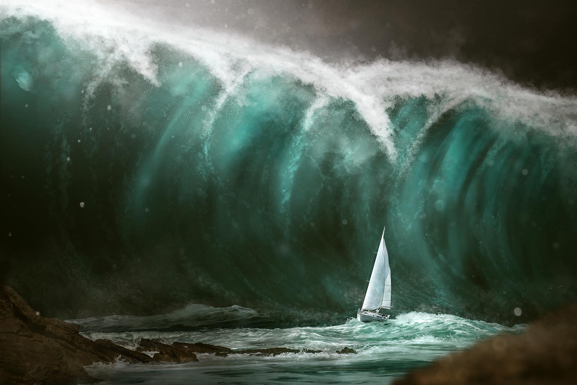
Contrary to common belief, the Mediterranean holds a significant and underrecognized tsunami risk, with waves capable of striking coastlines in minutes.
The Mediterranean Sea is often dismissed as a low-risk zone for tsunamis, but that assumption is increasingly being challenged. Historical records and modern simulations show that powerful waves have already struck the French Riviera and could do so again. Researchers studying the coastline around Nice have reached a clear conclusion: when minutes matter, preparation and fast evacuation are the only dependable ways to save lives.
Tsunamis, sometimes still referred to as tidal waves, are caused by sudden shifts in the seafloor, including earthquakes, landslides, or volcanic activity. Unlike ordinary wind-driven waves, they move vast amounts of water across entire ocean basins. In deep water, they may pass unnoticed, but as they approach land, they compress and surge upward, producing fast-moving floods and violent currents.
A tsunami may begin with the sea pulling back unexpectedly or rising in a series of waves rather than a single wall of water. Heights can vary from a few centimeters (inches) to several meters (feet), but the real danger lies in speed and force. Water rushing inland can exert several tons of pressure per square meter, enough to tear apart buildings, ports, and roads.
Globally, tsunamis have killed more than 250,000 people since 1970. Events such as the 2004 Indian Ocean disaster and the 2011 Tōhoku tsunami in Japan revealed how quickly entire coastlines can be overwhelmed, even in regions with advanced warning systems.
A risk that is not so farfetched after all
Tsunamis are commonly linked to the Pacific and Indian Oceans, leading many to assume the Mediterranean faces minimal risk. This perception can be misleading. In June 2022, UNESCO, which works to improve tsunami awareness globally, warned:
“Statistics show that there is a 100% chance of a tsunami of at least one meter high in the Mediterranean Sea in the next 30 years.”
After the Pacific, the Mediterranean basin holds the highest number of historical tsunamis recorded, of which several have impacted France’s Côte d’Azur coastline.
According to available data, around twenty incidents were reported in the maritime area along the French Riviera between the 16th century and the early 2000s, with waves often exceeding two meters.
Evacuation times that are often very short
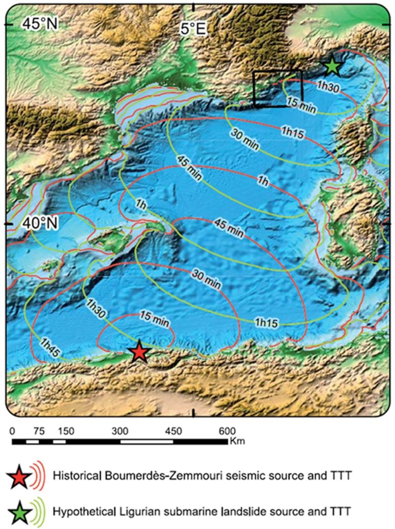
The sources of Mediterranean tsunamis can be local or distant. In some scenarios, run-up time for the first waves can be under ten minutes, particularly in the event of an underwater landslide or earthquake close to the coast, such as in the Ligurian Sea between Corsica and the Italian coast. Conversely, tsunamis generated further away from France, for example, off the northern coast of North Africa, can reach the French Riviera in less than 90 minutes.
The Boumerdès earthquake (Algeria) on May 21, 2003, caused havoc along the entire French Mediterranean coastline. A field enquiry showed that eight marinas on the French Riviera experienced significant sea level drops (from 50 cm to 1.5 m), basin purges, strong eddies and currents, and damaged boats, consistent with harbor resonance phenomena. The effects were observed on the French Riviera coastline an hour and a quarter after the earthquake.
Of more local origin, the tsunami in Nice on October 16, 1979, triggered by the underwater collapse of part of the construction site for the new commercial port in Nice (Alpes-Maritimes), adjacent to the airport, caused the deaths of eight people and significant damage in Antibes, Cannes, and Nice. The phenomenon was observed in Antibes for around thirty minutes.
Another scenario that could occur closer to the coast is that of the seismic tsunami that struck the Ligurian Sea on February 23, 1887, following an underwater earthquake measuring between 6.5 and 6.8 on the Richter scale. Contemporary accounts describe a sudden retreat of the sea by about one meter in Antibes and Cannes, leaving fishing boats high and dry, before the arrival of a wave reaching nearly two meters, which covered the beaches.
These events are a reminder of how we are completely taken by surprise, and how such short spaces of time show the limits of traditional warning systems. Coastal communities’ ability to evacuate quickly becomes crucial.
An operational warning system for France
France has had a national tsunami alert system that has been part of the Centre d’alerte aux tsunamis (Cenalt) since July 2012, in conjunction with the international system coordinated by UNESCO in the Mediterranean. This system makes it possible to rapidly detect potentially tsunami-generating earthquakes and transmit an alert in less than fifteen minutes to the interdepartmental crisis management operational centre (Cogic) and foreign alert centers.
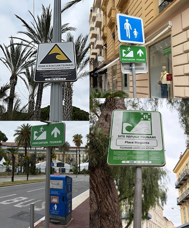
It is then up to the authorities to disseminate alert messages to the population, in particular via the FR-Alert platform, which allows notifications to be sent to the mobile phones of people located in the danger zone.
However, this global system only covers tsunamis caused by distant earthquakes and is not very effective in the case of local tsunamis or those caused by underwater landslides, where the time it takes for the tsunami to reach the coast may be less than the warning time. This is why it is important to raise awareness among coastal populations about detecting warning signs: felt earthquakes, abnormal sea movements, most often seawater retreats preceding the run-up of the tsunami, but not always.
Nice – Côte d’Azur coastline is highly at risk
Along the entire French Mediterranean coastline, an evacuation zone has been defined by government agencies and the University of Montpellier, based on altitude, distance from the sea, and historical data. It corresponds to coastal areas with an altitude of less than 5 meters that are less than 200 meters from the sea. Along river mouths, this distance is extended to 500 meters with respect to the estuary.
Including Corsica, 1,700 km of coastline, 187 towns along the French Mediterranean coast, and at least 164,000 residents would be affected. At the height of the summer, an estimated 835,000 beach users would also need to be taken into consideration in the event of a tsunami.
The Nice – Côte d’Azur metropolitan area is vulnerable for a number of reasons: dense urbanization, strong tourist appeal, and very busy beaches. Our photo analysis and modeling work have enabled us to estimate that tens of thousands of people are present in the area to be evacuated during periods of high visitor numbers (between 10,000 and 87,000 people on the beaches, depending on the season and time of day).
Evacuating ahead of a tsunami: the plan for Nice and surrounding coastal areas
When faced with a tsunami, evacuation is the only effective means of ensuring civilian safety. International experience shows that rapid and well-prepared evacuation procedures can save the vast majority of exposed populations. Reactive evacuation measures, for example, saved 96% of Japanese inhabitants when the major tsunami struck the Tōhoku coast on March 11, 2011.
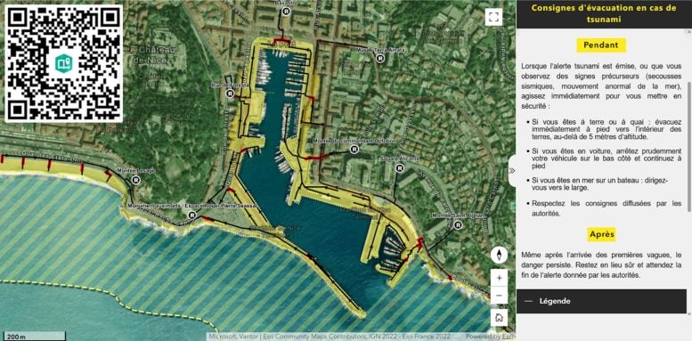
In Nice – Côte d’Azur, a comprehensive evacuation strategy has been developed and supported by scientific research led by the University of Montpellier’s Laboratory of Geography and Land Planning. It is based on optimized walking routes, taking into account slopes, obstacles, travel speeds, and congestion points. Refuge sites located out of “waves’ reach” were identified and validated by local authorities, and evacuation routes were devised using algorithms to find the fastest routes.
In total, nearly a hundred refugee sites have been mapped out and incorporated into operational evacuation plans designed to quickly guide people to safe places.
From science to action: preparing the population
Raising tsunami awareness should go beyond evacuation mapping: safety drills such as evacuation exercises, particularly in schools, or gradually introducing public warning signage; contribute to encouraging responsible behaviour. Several initiatives like these have been implemented in Nice via a project with students in Montpellier.
In Nice, a publicly accessible information platform with interactive maps also allows users to find evacuation zones, routes, and instructions to follow in the event of an alert. These tools contribute to the development of a genuine tsunami risk culture.
Becoming ‘Tsunami Ready’ territory
Beyond France’s Côte d’Azur coastal area, the information portal can be applied to other coastlines elsewhere in France and Europe, both in the Mediterranean and overseas, where tsunami run-up times can be just as short.
The initiatives that are being implemented in Nice are in keeping with UNESCO’s Tsunami Ready international recognition program (TRRP). This 12-point program aims to certify territories that are capable of anticipating a tsunami risk, prepare their populations, and coordinate an appropriate response.
The first towns to be awarded the label and that have benefited from our team’s scientific and technical support were Deshaies in Guadeloupe and Cannes, with Nice set to join the program in the near future.
When facing a wave that can arrive in a matter of minutes, being prepared to evacuate undoubtedly makes all the difference.
Adapted from an article originally published in The Conversation.![]()
Never miss a breakthrough: Join the SciTechDaily newsletter.
Follow us on Google and Google News.